1 Special considerations to the Israeli market
A physically impossible MNE occurs when the route
asks the user to take non-existent roads or to drive
illogically (ignores barriers, height differences, etc.).
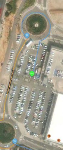
For example: In this example, the route asks the Users to reach the roundabout by directly crossing a barrier that marks the boundary of the parking lot and the road. You may notice that the barrier is insignificant; many vehicles might easily cross it if no parking cars exist. However, it isn’t logical conduct, and as such, it is regarded as a physically impossible MNE.
The tryrating vector map shows a typical road without the barrier but cross-
referencing with the GovMap vector map refutes it.
Correct Rating: MNE – Physically impossible: step 1 – Driver instructed to drive on the sidewalk and through barriers at 32.292889,34.862057 (see a 2021 satellite image of GovMap https://tinyurl.com/47rtupd5).
Here is another example:
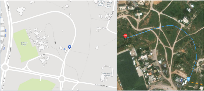
If the decision would be based only on the tryrating satellite image (right), it is an MNE because the route asks the user to take a non-existent road. However, according to both tryrating and GovMap vector (left) maps, we notice this is a standard way. The satellite image of GovMap confirms it, and by navigating through older satellite photos, we can see that this road was paved circa 2019-2020.
Turn restriction and U-turn MNEs are similar in their nature. Turn restriction MNE occurs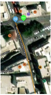 when the route asks the user to take a turn that isn’t allowed by law (but possible), and U-turn is a particular case of a turn restriction.
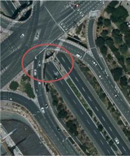
There are many subtleties in Israeli law regarding left turns and U-turns. As analysts, we should focus on road signage and other cues on the road. In this case, the route asks the user to turn left. The satellite (left) and vector maps don’t help us determine if this is a legal step. However, we might suspect this is too sharp an angle for turning left.
 We need to look for some clues, and GovMap is our first choice.
According to the 2021 satellite image of the location (in the middle of
the page), we try to locate traffic signs painted on the road. It is difficult to tell if there is (within the red circle) a left turn arrow because it is hindered by cars and trees. However, if we look at the 2019 satellite image of the location (down the page), we notice that no left turn is allowed because only straight arrows are painted on the road. We also might try the dated street imagery available after assuring there isn’t an apparent change in this route compared to the
GovMap satellite image. This road didn’t change, and the street imagery confirms our findings.
U-turn isn’t allowed in Israel if a left turn is forbidden or if it might interfere with the traffic or put other drivers at risk.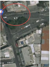
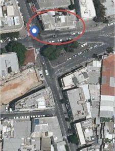
Here, the route requests the user to take a left turn and merge onto Menachem Begin Street.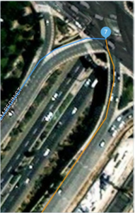 This is effectively a U-turn.
The tryrating image quality (the top photo) isn’t the best, but we suspect a U-turn isn’t allowed here due to the relatively sharp curve of such a turn.
We can confirm in a 2021 satellite image of GovMap that a left turn isn’t allowed according to the painted path signs on the road, guiding the user to keep driving within the same path.
 Correct Rating: MNE – Illegal U-turn. Step 2 – The route asks the user to turn left and merge onto Menachem Begin Street at 31.784984,35.199155. This is effectively a U-turn, and according to a 2021 satellite image of GovMap (https://tinyurl.com/mwbe95v7), a U-turn isn’t allowed in this junction; therefore, this is an illegal U-turn.
4 Major road misalignments
A misalignment is any section of the blue line that does not match the current real world shape and position of the roads being used.
Major road misalignments that are not a result of a turn channel (because it is missing, misaligned, or non-existent) occur if either condition is met:
 the painted/physical turn channel divider is over 100 meters.
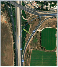 blue line doesn’t match the actual road. The satellite image of TryRating (below) confirms it.
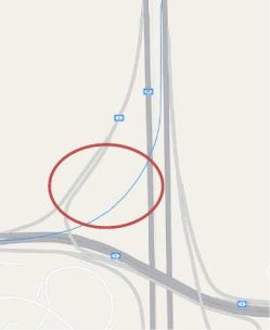
This isn’t a turn channel situation, as the highway split contains a non-lane space. We now would check which criterion is more
suitable. The second criterion seems more appropriate as this misalignment is transverse.
The green line (to the left) is about 93m long, so this is a major misalignment MNE according to the second criterion above.
Correct Rating: MNE – Major Road misalignment: step 13 – Major road misalignment (4.1.1, second criteria): no road at 32.137727,34.811443 (see
GovMap t.ly/JMOn).
5 Tips