1. Introduction
This document explains the MNE Driving Routing evaluation and the rules to be followed when evaluating a route. You will use a combination of the provided map layers and external resources (other mapping services, imagery of streets, etc) to understand the current, real life layout (or “ground truth”) of the roads used and determine if the route you are reviewing contains errors.
There are many different errors that can cause a user to have a substandard driving experience. In this task, we will focus on identifying Major Navigational Errors (MNEs)— driving maneuvers that are illegal or impossible for a driver to perform based on local law and/or the road ground truth. There are many types of routing and guidance errors that are not considered Major Navigational Errors. In this evaluation, we refer to those as “Non-MNE Issues”.
The information produced from these tasks will be used for evaluation purposes only.
2. Anatomy of the Rating Tool
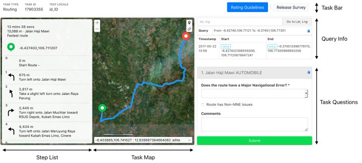
The interface to the MNE Driving evaluation can be divided into 5 sections:
This section provides an outline of the first 4 sections of the rating tool. Task Questions are discussed in detail in Section 4.
Name | Screenshot | Description |
Task Type | 
| The name of the task being worked on. |
Task ID | 
| A number that identifies the specific task item. Use this number whenever you communicate about a task or rating |
Test Locale | 
| The country and language combination this task is for, displayed using two-letter country and language codes |
Rating Guidelines | 
| A link to the rating guidelines for the task being evaluated |
Release Survey | 
| Allows you to skip a survey in rare cases when a technical issue prevents successful rating. |
Name | Screenshot | Description |
Step List | 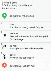
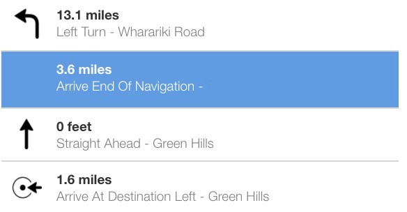
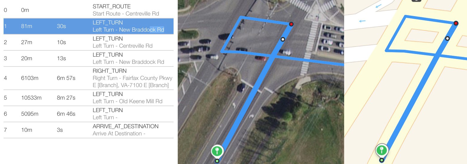
| The Step List is located on the left side of the Rating Tool and includes: •estimated time of arrival (ETA) •any applicable advisory notices (ex. Toll Required) •coordinates for the route’s Origin and Destination Pins •a Step-by-Step List of route directions In MNE Routing evaluation, we are not evaluating the wording of the guidance given by the directions in the step list. The step list is used primarily as a route reference and for giving context to the directions indicated by the blue line. In general, you will not indicate an MNE based solely on the presence of an incorrect road name, wrong step distance, or poorly described maneuver within the Step List. The primary exception to this is routes that begin with a U-Turn (see Section 4.6). The Step List can also be used to control the appearance of the Task Map: •Click on a single step in the Navigation Directions to highlight that route step in the Map View. •Double click on a step in the Navigation Directions to zoom in on that step in the Map View. •If the Route Step list is longer than can be displayed on the screen, the Step List will become scrollable. Note: In some cases, the text in the step list may be presented in a foreign language. Foreign language in the step list is not sufficient reason to release the task or justification for a Major Navigational Error rating. |
Route Step | 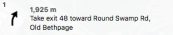
| Each Route Step will begin with an individually numbered Route Step ID and may include an arrow/icon, indicating the step’s overall guidance, as well as distance to the next maneuver, and any relevant street names. The final step for each route will indicate the orientation of the destination to the End Point (ahead, left, or right). |
ETA | 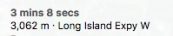
| The estimated time to reach the destination and the corresponding route distance. Each ETA will also include the name of the primary road that is used along the route. In the MNE Driving evaluation, the ETA is provided only as a reference. |
Name | Screenshot | Description |
Advisory Notices | 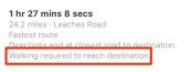
| Some routes may have advisory notices that indicate a special condition applying to the route. Common advisory notices are: 1)Tolls required 2)May include unpaved roads 3)Walking required to reach destination These notifications may be translated into the appropriate language for the locale being evaluated. The screenshot to the left has the advisory notice highlighted in red. |
Origin Pin | 
| Indicates the approximate, anonymized location of a user’s location when making a route request. Note: In the MNE Driving evaluation, a mismatch between the start of a route (as indicated by the blue route line) and the Origin Pin is not considered a Major Navigational Error. |
Destination Pin | 
| Indicates the approximate, anonymized location of the user’s requested destination. Note: In the MNE Driving evaluation, a mismatch between the end of a route and the Destination Pin (as indicated by the blue route line) is not considered a Major Navigational Error. |
Route Step ID | 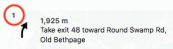
| Individual Route Step IDs are located in the upper left corner of each Route Step. In this screenshot, a red circle is used to highlight the Route Step ID location. |
Step List Symbols | 
| Proceed forward |

| Turn right | |

| Turn left | |

| Destination is ahead | |

| Destination is on the right | |

| Destination is on the left |
Name | Screenshot | Description |
Task Map | 
| The Task Map displays the route you will be evaluating. |
Name | Screenshot | Description |
Zoom Controller | 
| A Zoom Controller allows zooming in and out of the Map View. You can change the zoom level by clicking the + (zoom in) or – (zoom out) buttons. |
Drop Location Pin | 
| Select the Pin Drop Tool and then click on the map to drop a pin. Once the pin has been placed, a flag that lists the pin’s Address and Coordinates (latitude and longitude) will appear. Select ‘Delete Pin’ from the pin flag to remove it from the map. |
Measure Distance | 
| Select the Measure Tool and then click on two points on the Map. Once two points have been selected, a dashed line will be drawn between those points and the measurement, determined in meters, will appear next to the Measure Tool icon. Select the Measure Tool again to toggle it off. |
Look Around |
| Select the Look Around icon to open the Look Around menu to fetch street view imagery for your currently viewed map. Note: This icon will only be available for routes with fetchable street view imagery. |
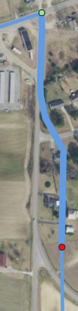
Map Layer Selector | 
| The Map Layer Selector that allows you to switch between Map Layers is located in the bottom right corner of the Map. •Standard – The Standard Map depicts streets and highways, towns and cities, business names, green spaces, and bodies of water, etc. •Hybrid – Elements from the Standard Map, including roads, street names and town/city names, are superimposed upon a Satellite View. •Satellite – An unlabelled, photographic satellite view. |
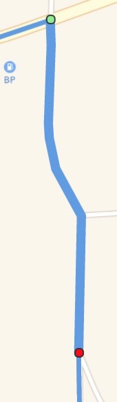
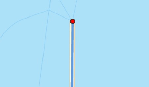
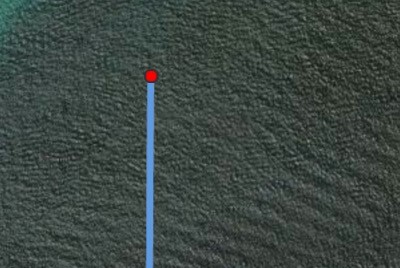
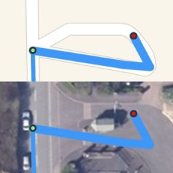
Route Line | 
| A blue Route Line indicates the route between the Start and End points of the route. |
Route Step | 
| Selecting a Route Step on the Step List will bold the corresponding segment of the Route Line. The start of the highlighted Route Step will be indicated with a green dot. The end of the highlighted Route Step will be indicated with a red dot. The end of the Route Step will also have a white arrow corresponding with direction a driver will follow to proceed to the next step. |
Name | Screenshot | Description |
Route Step Arrow |
| The arrow at the end of a route step that indicates the direction of the maneuver. An incorrectly rendered Route Step Arrow is not justification for an MNE rating. You should base your understanding of the route’s maneuvers off the route line and the maneuvers that will be required in order to continue following the route line. |
Origin Pin | 
| The green Origin Pin indicates either the user’s location when the route was requested or the location that the user requested the route to begin at. |
Destination Pin | 
| The red Destination Pin indicates the location that the user wants to navigate to. |
2.4. Query Info
Name | Screenshot | Description |
Go To Lat, Lng | 
| A tool that allows you to instantly zoom to specified latitude and longitude coordinates in decimal notation. |
Query | 
| An overall name for the query that can be used, in addition to the Task ID, to communicate about the rated query. |
Timestamp | 
| The time when the route query was issued. |
Start | 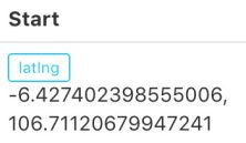
| The Origin coordinates for the query |
Name | Screenshot | Description |
End | 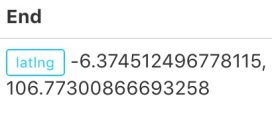
| The Destination coordinates for the query. |
3. Task Questions
In this task you will answer questions on Major Navigational Errors, any Non-MNE issues noticed, and provide a comment whenever a Major Navigational Error or Non-MNE issue has been found.
3.1. Major Navigational Errors (MNEs)
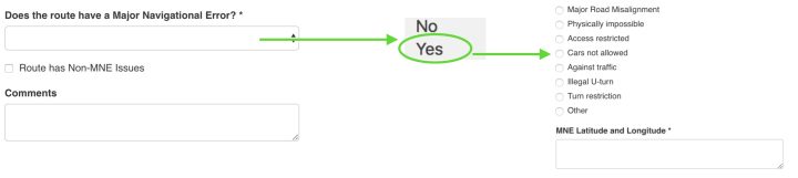
The first question you will answer is “Does the route have a Major Navigational Error?” Major Navigational Errors are illegal or impossible route maneuvers that cause a route to be unusable by drivers. If you spot any of the errors from the below list, select Yes, indicate the MNE type and provide the latitude and longitude of the MNE in the newly shown text field MNE Latitude and Longitude. Do not enter anything other than the copied latitude and longitude into this field. Explanatory text should go into the Comments text box.
While some routes may have multiple Major Navigational Errors, you are only expected to mark a single MNE per route. Do not continue to look for additional errors along the route after you have a found a MNE. In some cases, multiple MNE types may apply to a single error or occur at the same time, please see the section Choosing Between Multiple MNE Types for how to handle cases where multiple MNE options apply.
Major Navigational Error | Explanation |
Major Road Misalignment | The route uses roads that exist in real life but there are significant errors in the road layout and position when compared to the ground truth. |
Major Navigational Error | Explanation |
Physically Impossible | The route uses roads that do not exist in real life or maneuvers that are impossible to perform (ex. Maneuver ignores differences in overpasses/ underpasses, physical barriers between the roads). |
Access Restricted | The route navigates through an area that limits road usage to only those with special access (private roads, parking lots, gated communities, military bases). Access Restrictions is also applied for time based restrictions based on the expected time the user would arrive at that step in the route, if a route time is provided. |
Cars Not Allowed | The route uses a road that does not allow cars (ex. bus/motorcycle/bicycle/ pedestrian only roads). |
Against Traffic | The route navigates the wrong way down a road. Against Traffic is primarily used when we have evidence the user will believe that they are being routed the wrong way down a dual-carriageway or one-way road. |
Illegal U-Turn | The route asks you to make an illegal U-Turn, including illegal U-Turns at the start of a route. |
Turn Restriction | The route asks you to take an illegal turn. If a route time is provided, we must also consider time-of-day turn restrictions. |
Other | These can be used for any error that causes the route to be illegal or impossible that does not fall into the above categories. Your comment should explain this error in detail. Please include links to any sources used to understand the error. |
3.2. Non-MNE Issues
While reviewing routes for Major Navigational Errors, you might notice things that look strange but do not meet any of the criteria for Major Navigational Errors. Routes with minor issues should be classified as having a Non-MNE issue if you think the route has an issue that would create poor or mildly confusing user experience.
A route may have both Major Navigational Errors and Non-MNE issues.
The Non-MNE Issues option has been left intentionally open-ended as the types of navigation errors that provide a confusing experience may vary from route-to-route and area-to-area. Some common examples that may be considered Non-MNE Issues include:
Typically, we will not consider an inefficient route (one that takes slightly longer than alternatives to navigate from origin to destination) a “Non-MNE Issue”. However, if you notice that the route is extremely inefficient due to missing major roads, ferries, etc. then select Route Has Non-MNE Issues.
This evaluation’s primary focus is on Major Navigational Errors. Do not go out of your way looking for Non-MNE Issues or perform additional research explicitly to confirm a Non-MNE Issue. You should only indicate a Non-MNE issue if you happen to notice one while looking for Major Navigational Errors.
3.3. MNE Latitude and Longitude
When you have found an MNE, you must provide the latitude and longitude of the MNE. Please copy and paste the coordinates from the pin tool and ensure that the provided latitude and longitude are decimal notation (ex. -6.3745124, 106.773008) . Do not provide any additional information in this field.
3.4. Comments
Whenever an MNE is discovered, leave a comment that includes the Step ID of the MNE, a brief explanation of the MNE you have found, and links to any supporting evidence for the discovered MNEs. To help with leaving concise comments, for long URLs, you may use URL Shortening services to leave smaller links links.
4. Major Navigational Error Criteria
4.1. Major Road Misalignments
In the MNE Driving Routing evaluation, a misalignment is any section of the blue line that does not match the present day ground-truth shape and position of the roads being used. These misalignments can range in severity. Most cases of misalignment are minor and unlikely to be noticed by a driver using the route. Only major road misalignments that are likely to cause a navigational error should be rated as a Major Navigational Error. This section details the type of misalignments we expect to cause navigational errors.
4.1.1. Major Road Misalignment Criteria
We consider a misalignment to be a Major Road Misalignment when:
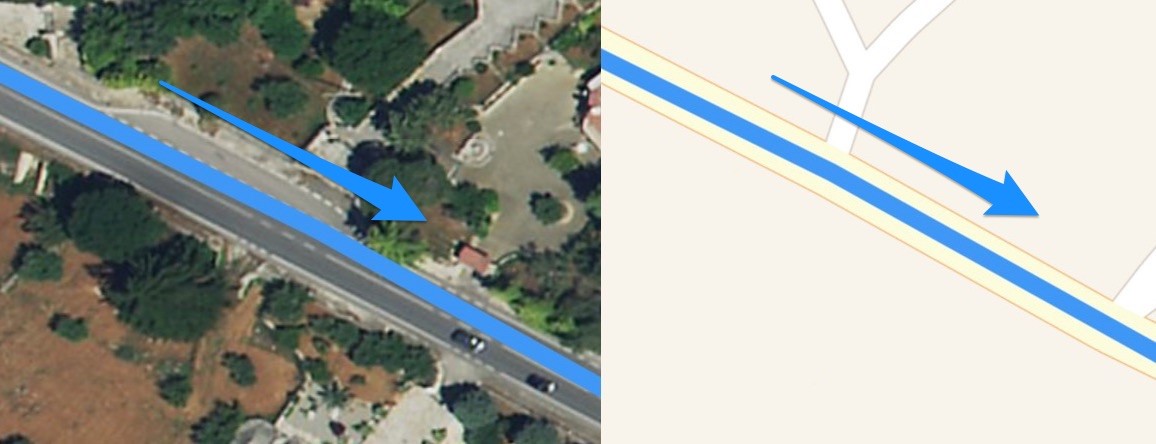
4.1.1.1.Turn Channels
A turn channel is any turn lane with a:
Highway/interstate ramps are considered turn channels. In most cases, a forking road or splitting highway will not be considered a turn channel.
Do not consider a lane(s) to contain a turn channel if it is separated from other lanes by:
Screenshot | Explanation |
| Turn Channel |
The left turn lane is separated with a non-lane space which should be considered a turn channel. | |
| Turn Channel |
The turn lane is separated with a non-lane space which should be considered a turn channel. |
| ||||||||||||||
Screenshot | Explanation | |||||||||||||
| Not a Turn Channel | |||||||||||||
The right turn lane is separated only by a bike lane and should not be considered a turn channel. | ||||||||||||||
| Not a Turn Channel | |||||||||||||
The highway split contains a non-lane space, however, this is not a turn lane and therefore should not be considered a turn channel. In most cases only highway exits should be considered turn channels. | ||||||||||||||
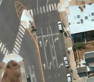
If the blue line does not use the turn channel and instead shows a typical turn or it is misaligned with the ground truth turn channel, we should only rate Major Navigational Error with Major Road Misalignment if:
1) The distance from the beginning of the painted/physical turn channel divider to the end of the painted/physical turn channel divider is over 100 meters
OR
2) Any point along the center of the closest usable lane in the turn channel is 50 meters away from the closest point on the blue line.
If the measured distance is not large enough to meet the above criteria, we consider it a Non-MNE Issue.
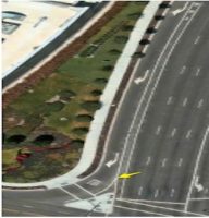
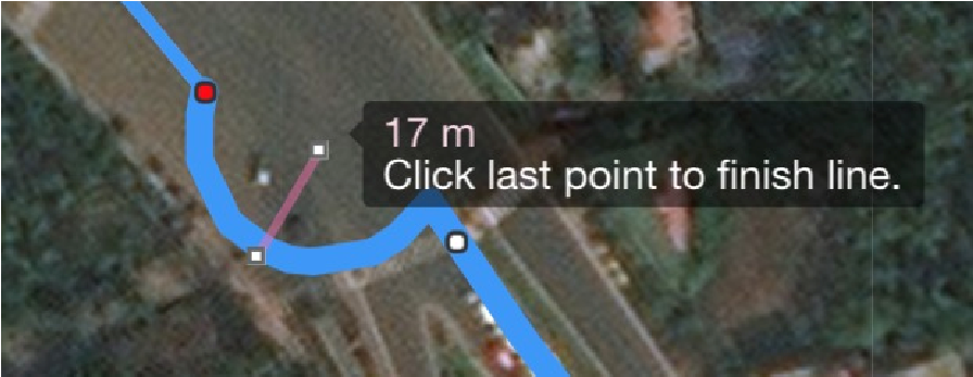
4.1.1.1.1.Measuring Turn Channel Divider Length
If the blue line does not use a turn channel, the first criteria used to determine if the error should be an MNE is the length of the misaligned turn channel. Measure from the beginning to the end of the divider for the turn channel.
Please keep in mind that the start of the turn channel is considered to be at the point where the painted divider begins to diverge to create a non-lane space.
See examples of turn channel start points below:
Screenshot | Explanation |
| Painted and Physical Barrier Turn Channel |
This is a slip lane with a physical barrier. However, before the physical slip lane barrier, white lines have been used to extend the barrier’s shape. The beginning of the painted divider marks the start of the slip lane, where the white line begins to diverge and create a non-lane space indicated by the yellow arrow. | |
| Bike Lane with a Turn Channel |
The slip lane is considered to start at the point where the white line diverges to create a gap or a non-lane space indicated by the yellow arrow. Before this slip lane, there is a long bike lane which should still be treated as a lane rather than a non-lane space. | |
| Highway Exit Turn Channel |
This highway split turn channel starts at the point where the white line diverges to create a non-lane space indicated by the yellow arrow. |
The goal in measuring turn channels is to ensure that users will not miss a turn channel due to delayed instruction. Misalignments that occur after the beginning of the turn channel on the blue line should be measured using traditional 50 meter misalignment rules.
Below are several examples of which segment of a turn channel to measure.
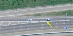
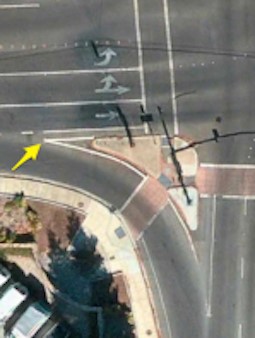
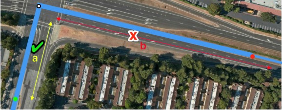
Screenshot | Explanation |
| Slip Lanes |
If the misaligned turn channel is a slip lane measure along the side that is adjacent to the road the route is coming from, not the road the route is turning onto. | |
| Highway Exit |
If the misaligned turn channel is a highway exit measure to the point where the blue line represents the exit. | |
| Highway Entrance |
In the case to the left, a highway entrance is misaligned with the distance from the beginning of the misalignment and the end of the turn channel being over 100 meters. However, because this misalignment occurs only at the end of the turn channel, we do not measure it using that rule and would not consider it an MNE. |
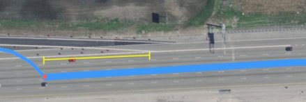
Use the measuring tool to determine the length of the turn channel. If this segment is over 100 meters, the misaligned turn channel qualifies as a Major Road Misalignment. Otherwise, the misaligned turn channel is considered a Non-MNE Issue.
Screenshot | Rating and Explanation |
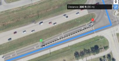
| MNE – Major Road Misalignment |
The route does not follow the turn channel lane used for the left turn. The turn channel is 102m from the beginning of the non-lane space to the end. This error qualifies for a Major Road Misalignment. | |
| MNE – Major Road Misalignment |
The route is misaligned with the turn channel lane used for the highway exit. The turn channel is 117m from the beginning of the non-lane space to the point where the turn is displayed by the blue line. This error qualifies for a Major Road Misalignment. | |
| Non-MNE – Minor Road Misalignment |
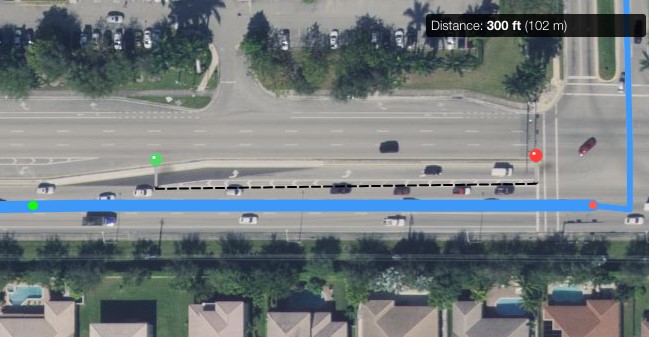
The route does not follow the turn channel lane used for the left turn. The turn channel is 86m from the beginning of the non-lane space to the end. This error qualifies for a Minor Road Misalignment. | |
Screenshot | Rating and Explanation |
| Non-MNE – Minor Road Misalignment |
The route does not follow the turn channel lane used for the right turn. The slip lane is 48m from the beginning of the non-lane space to the end. This error qualifies for a Minor Road Misalignment. The slip lane should only be measured on the side of the road the route is turning from, not the road the route turns onto. | |
| None |
This example would not be considered a misaligned turn channel. The blue line jumps over to the exit lane before the start of the turn channel, which is at the point the white line splits creating a non-lane space. | |
| None |
This example would not be considered a misaligned turn channel. The blue line jumps over into the turn channel lane before the start of the turn channel. The turn channel begins at the point where the white line splits creating a non-lane space. |
4.1.1.1.2.Measuring Distance to the Blue Line
If the blue line does not use a turn channel and the first error criteria does not apply, the second criteria used to determine if the error should be an MNE is the distance between the turn channel lane and the blue line. Measure from the closest points on the blue line to the center of the turn channel lane. If that closest point is more than 50m to the center of the turn channel lane the misaligned turn channel qualifies as an MNE – Major Road Misalignment. Otherwise, the misaligned turn channel is considered a Non-MNE Issue.
See examples of distance measurement points below:
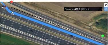
Screenshot | Rating and Explanation |
| Non-MNE – Minor Road Misalignment |
The route does not follow the turn channel lane used for the right turn. The slip lane is 48m from the beginning of the nonlane space to the end. This error qualifies for a Non-MNE Minor Road Misalignment based on the first criteria. The slip lane should only be measured on the side of the road the route is turning from, not the road the route turns onto. The next step would be to measure the distance of the closest point of the blue line to the turn channel. In this case the distance to the center of the turn channel lane is under 50m which should be considered a Non-MNE. | |
|
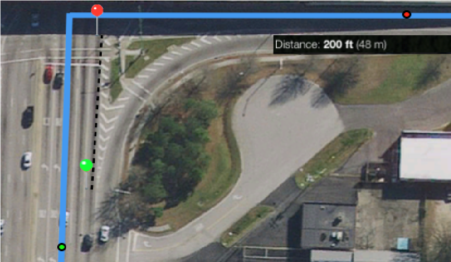
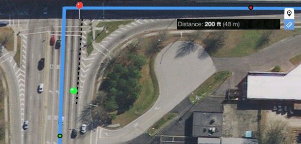
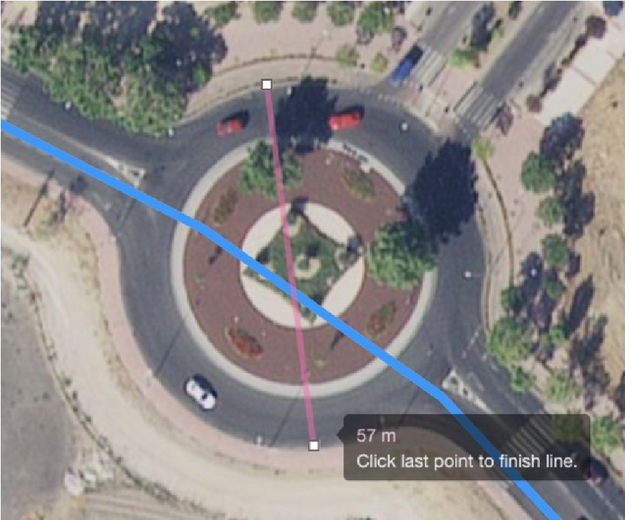
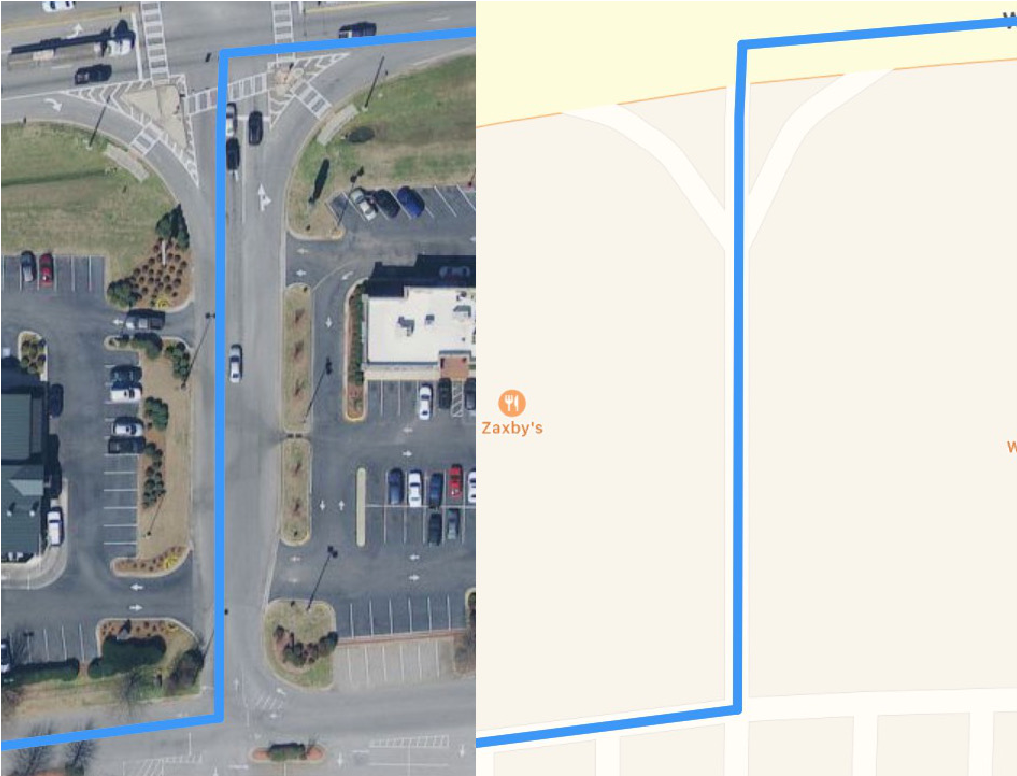
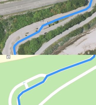
4.1.1.2.Roundabouts and Traffic Circles
Roundabouts and traffic circles are circular intersections where traffic flows in a single, circular direction around a center point. Drivers will usually need to yield to traffic already in the roundabout before being able to enter. After entering the roundabout, they drive around the center point until they reach an exit point to the road they wish to travel on
To qualify as a Major Road Misalignment, a missing or non-existent roundabout must be 50 or more meters wide at the edge of the outer lane at the widest point of the roundabout. If the widest point of the roundabout is under 50 meters, rate it as a Non-MNE Issue.
If the roundabout exists only on the blue line, you should measure from the widest point on the blue line to the implied center-point of the roundabout and double that width. If the doubled width is greater than 50 meters, it should be considered a Major Road Misalignment MNE.
Roundabout | Description |
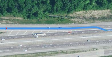
| A 57 meter wide space exists from edge-to-edge on this roundabout. A missed roundabout like this should be rated as having a Major Road Misalignment. |
 | Here, a roundabout exists only on the blue line. In reality, we have an intersection that drivers can proceed directly through. From the outer edge of the roundabout to the approximate counterpoint of the roundabout is 17 meters. Doubling this width gives us an estimate roundabout width of 34 meters. As this is below the 50 meter threshold, this example should be rated as having Non-MNE Issues. |
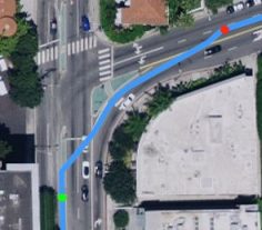
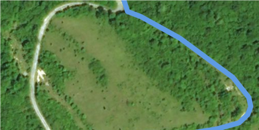
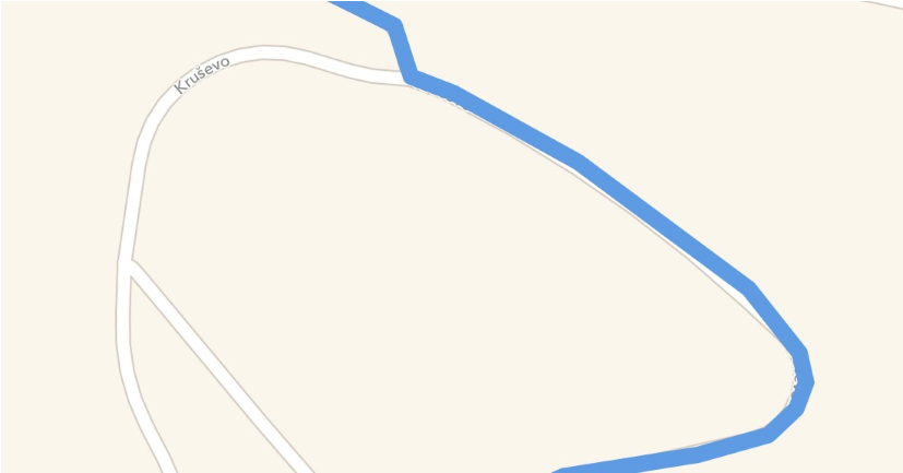
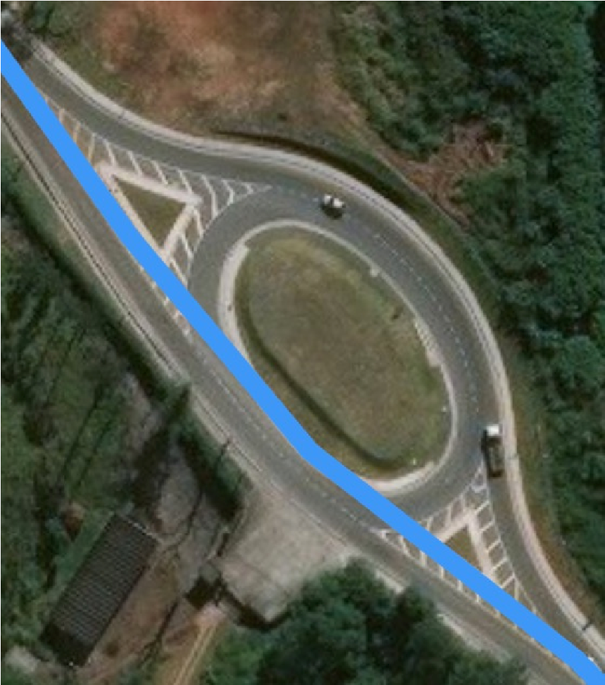 | In this case, there is a quasi-roundabout that is over 50 meters at its widest point. This roundabout is located at: -23.709674,-46.879. This roundabout has lanes on each side that allow thru-traffic to continue straight without ever having to truly enter the roundabout. Traffic that wishes to change directions can merge into the roundabout lane. Since our route does not interact with the roundabout but just drives along-side it, we do not apply roundabout rules and do not consider this to be a Major Road Misalignment for the missing roundabout. For a quasi-roundabout like this, we still need to consider general misalignment errors. Depending on the direction of travel, it is possible for the blue line to be aligned on the wrong side of a quasi-roundabout. If the distance to the actual portion of the road they should be on to the blue line is greater than 50 meters, it should be considered a Major Road Misalignment. A case like this should not be marked as an a Against Traffic error unless we have reason to suspect the route is explicitly directing users Against Traffic. See section Against Traffic for additional details on how to apply Against Traffic rules. |
4.1.2. Minor Road Misalignments
Most routes will have some level of misalignments occurring throughout the route. Minor misalignments are often caused by small errors in road shape data and the stylistic decisions made on how to visualize roads on a map. It is important to be able to understand the difference between minor road misalignments (whether they are caused by stylistic decisions or incorrect data) and Major Road Misalignments.
When reviewing a route, minor misalignments do not require a comment to be left. However, minor misalignments that have been explicitly defined (missing turn channels and roundabouts) should have a rating of “Route has Non-MNE Issues” and a comment explaining the misalignment.
Screenshot | Explanation |
 | A blue route line is navigating through a parking lot. In the satellite imagery, we can see that our parking lot lane is slightly misaligned, causing the route line to run very close to cars rather than through the center of the parking lot lane. Because this misalignment is so slight, it is extremely unlikely it would be detectable by a driver. No driver would drive uncomfortably close to the cars on the west because of this. While slight misalignments like this may cause our route to look like it is going Against Traffic, in the context of how roads are typically drawn on the Standard Layer, we can expect that no driver seeing this route would drive on the wrong side of the parking lot lane due to our blue route line’s alignment. |
 | The blue line is aligned directly over the center point of both directions of traffic. While the blue line is not aligned with the side of the road the driver would expect to be on, we do not consider this to be an Against Traffic or Misalignment error as no driver would think they are being told to drive directly in the middle of the road or against traffic because of this. It is expected that the blue line will be aligned over the center point of most roads. |
| The blue line is initially aligned too far to the east and, on the satellite layer, looks like it has been placed above the oncoming lane of traffic. This misalignment is under 50 meters. Additionally, while it is aligned somewhat poorly, it’s unlikely a driver would see this and think they are intended to drive on the wrong side of the road. The alignment here does not merit a rating of MNE. For more information on Against Traffic errors, please review the Against Traffic section. |
4.1.3. Misalignment Examples
Example One
Issue Lat/Lng: 56.060969,10.196377
Screenshot
|
Explanation |
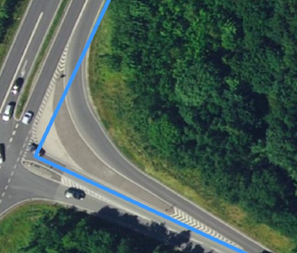
| At the end of Step 4, the user is asked to make a right turn that ignores the existence of a turn channel. To determine if this is a Major Road Misalignment, we must measure if 1) the distance between the start of the turn channel is over 100 meters off from the physical end of the turn channel and 2) if any point in the center of the closest lane in the turn channel is 50 meters off the closest point on the blue line. |
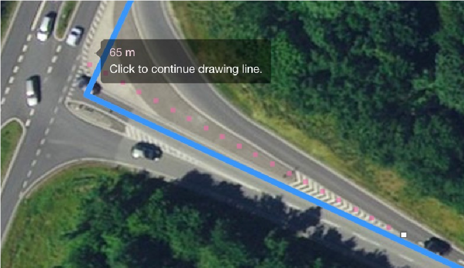 | The distance from the beginning of the turn channel’s painted divider to the end of the physical divider is 65 meters. This does not meet the criteria for a Major Road Misalignment error for turn channels. |
 | No distance in the ground truth turn channel is over 50 meters off from the closest point in the blue line. As such, this missing turn channel should receive a rating of Non-MNE Issues. |
Example Two
Issue Lat/Lng: 35.50664,-78.517989
Screenshot | Explanation |
| The route shown has a mismatch with the road’s true shape. We show the road slightly curving where it does not. Even though the road’s shape does not match what we have, we should not consider this a Physically Impossible error because the road does exist — the basic instruction we are giving to the user is possible to follow. Additionally the road is not misaligned over 50 meters, so this does not meet the criteria for a Major Road Misalignment. For a minor misalignment like this, you should select the option “Route has non-MNE Issues” and explain the error in your comments. |
Example Three
Screenshot | Explanation |
| In reality, the road the route uses proceeds straight. For some reason, the blue line for this road curves north and then back south. Because this misalignment is under 50 meters, it should be considered a minor misalignment. It is not required to check Non-MNE Issues for a case like this. |
Example Four
Screenshot | Explanation |
| At the end of the shown step, the user is traveling eastward. We ask the user to make a right turn, missing the turn channel and instead taking a sharp right turn after the turn channel. Even though this turn channel is non-standard (had both directions of traffic on it), we still rate it using the turn channel rules. Because the center of the correct lane from the turnchannel is never more than 50 meters off from the blue line, this should be rated as having Non-MNE Issues. |
Example Five
Screenshot | Explanation |
| In this route, our line is not aligned well with the road. This is an obvious misalignment as a result of different road data being used to generate the blue route line and Standard Layer. Do not rate based on the Standard Layer. You should assume the Standard Layer a driver sees will match the blue route line. It’s likely a user here would not be confused by the road indicated. The map they are shown would have the blue line align with the underlying road that is capable of traveling south. The geometry is largely the same as reality, just poorly aligned. As it is under 50 meters off and not expected to be confusing, we would consider this a Non-MNE issue. |
4.2. Physically Impossible
A Physically Impossible MNE should be selected when the route uses roads that do not exist in real life or requires you to perform impossible driving maneuvers (ex. Maneuver ignores differences in overpasses/underpasses, physical barriers between the roads, navigates through impassible longterm construction).
4.2.1. Physically Impossible Examples
Example One
Issue Lat/Lng: 29.710573,-95.20848
Screenshot | Explanation |
| In the route shown, the route makes a left turn to proceed south. The satellite layer available in TryRating makes this case appear as if the route is navigating through a road that does not exist and then directly through multiple buildings. As always, you should use multiple sources to review the route. If possible, review street level imagery and alternate sources to determine if the satellite tiles in TryRating are reflective of the current road network. Since research fails to indicate the presence of a road where the route indicates, it should receive a rating of Physically Impossible for using roads that do not exist and indicating we should drive through a building. |
Example Two
Issue Lat/Lng: 45.452432,-73.749772
Screenshot | 
|
Explanation | Using the satellite layer, there is an immediate and obvious issue with how we exit this parking lot. When you see an error like this, you should consult with other sources to verify that our satellite imagery is current. If, when reviewing other sources of satellite imagery and street level imagery, you are unable to find any evidence that our satellite layer is outdated, the appropriate rating is Physically Impossible MNE. |
Example Three
Issue Lat/Lng: 11.9416,121.946233
Screenshot | Explanation |
| This route indicates a road exists in the middle of what is clearly the ocean. After investigating the route and becoming certain that the road indicated is not actually an underwater tunnel or ferry, we can rate this as having a Physically Impossible MNE for ending on a non-existing road. |
Example Four
Issue Lat/Lng: 45.476879,17.528236
Screenshot | Explanation |
| This route indicates that the road the user is on continues on east before looping back around. However, in the provided satellite layer imagery, it looks like the road indicated may not exist. The best way to confirm that our imagery is up to date is to compare it to multiple alternate sources. In this case, after comparing, we can conclude there is no road where we have drawn our blue route line. In reality, it looks like there may be a dried up stream, river-bed, trail or other feature there that has been inappropriately mapped as a road. The only road that exists in this area is the one on the west. Before answering this item, we must first determine what type of MNE it is. Certainly, the road is over 50 meters off and could qualify as a Major Road Misalignment if we believe that we have simply drawn a road incorrectly. However, if we have reason to believe we are not drawing a road incorrectly but rather instructing a user to use a road that does not exist, the best answer is instead Physically Impossible. So we must ask ourselves, do we have reason to think that the route may be instructing users to use a road that does not exist? |
Screenshot | Explanation |
 | While we can see both roads on the Standard layer, the Standard layer may be generated from different data than the route line and should not be used as evidence. Instead, we should consult the step list to see if we are instructing drivers to use a non-existent road name, research the ground truth for this area to determine if there is any reason an extra road may have been mapped, and use clues from how we’ve mapped this road to come to a conclusion. As already mentioned, this road does look to align with an area that could have been mistakenly mapped as a road. Because of this, we can make the assumption that this route is instructing users to use a road that does not exist rather than drawing an existing road incorrectly. As we have routed on a non-existing road, we should indicate this route is Physically Impossible. |
4.3. Access Restricted
An Access Restriction MNE occurs when:
Routes whose blue route line begins or ends in a restricted access area or on a private road are assumed to have access to those roads and areas.
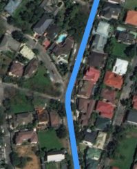
For example, a route that ends in a gated community, where only residents and invited guests are allowed in, is fine. Because the route ends within the gated community, we should assume that the route requester is a resident or invited guest. However, if a route does not end within the gated community but simply uses roads within the gated community to reach its destination, it would be considered an access restriction as there is no assumption an average driver would have access to the gated community’s roads.
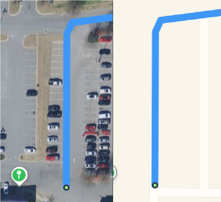
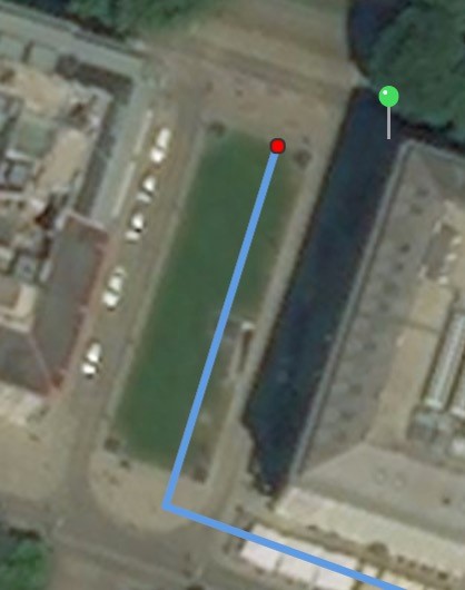
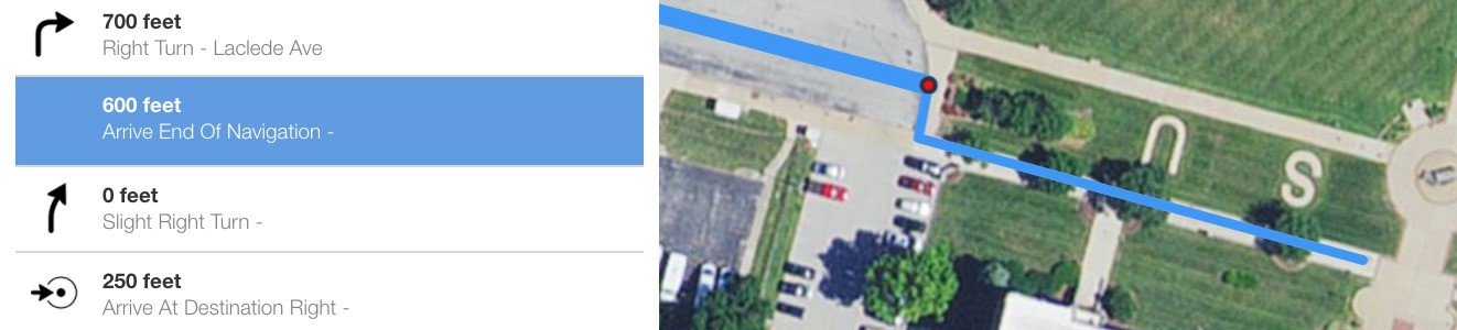
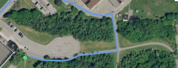
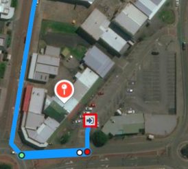
Access Restricted should also be used for routes that take shortcuts through the parking area of a parking lot and do not end in an area associated with that parking lot. For example, in the route to the right, we take a turn through a parking lot and then exit the parking lot to proceed to the destination. A route like this should be rated as Access Restricted.

However, it is completely appropriate to route through public roads that are inside shopping areas and connect to parking lots. For example, in the image to the right, we have a route that navigates through the Stonestown Galleria shopping mall in San Francisco at lat/lng: 37.727038, -122.476670. These roads used are named, public streets and it’s completely expected that members of the public will use these roads even when not routing to the Stonestown Galleria or a store in the shopping area. We would not consider a case that uses these main roads in the Stonestown Galleria shopping mall to have an access restriction, even if the route does not end in the Stonestown Galleria shopping mall.
4.3.1. Access Restriction Examples
Example One
Issue Lat/lng: 14.651184,121.087487
Screenshot | Explanation |
| The user is driving from southward. Along this step, the route travels through a gate checkpoint into an area restricted only to residents. Because the route does not end within the restricted community, it is considered an Access Restricted MNE. Cases like this illustrate the important of checking as many areas as possible using street level imagery. Using only satellite tiles does not make this segment appear particularly suspicious. |
Example Two
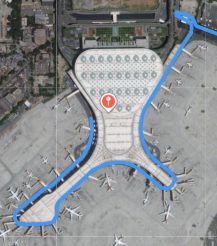
Issue Lat/lng: 19.097129,72.874664
Screenshot | Explanation |
| This route ends on the tarmac of an airport. The blue route line is following a road that outlines the airport. There is a security checkpoint at 19.100802,72.877051 that would prevent most drivers from being able to access this road. However, because the blue route line ends within a restricted access area, we assume that the driver requesting the route has access and would not consider this an MNE. |
4.4. Cars Not Allowed
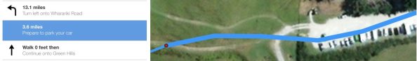
A Cars Not Allowed error occurs when the route uses a road that does not allow for the usage of a typical car. Common examples of these are roads or pathways that are limited to buses, motorcycles, bicycles and pedestrians.
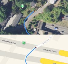
Unlike the Access Restriction MNE, a Cars Not Allowed MNE applies even for cases of Cars Not Allowed areas at the beginning or end of the route. The only exception for this is when step guidance has indicated the use of a pedestrian walkway to end the route.
In the Step Guidance, we will indicate Pedestrian walkways in one of two ways:
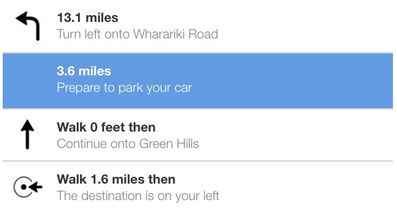
Do not consider if a user is legally allowed to park their car at the step where “Prepare to park your car” is indicated. This guidance is not intended to indicate a specific parking spot but rather that the user will need to park and proceed on foot from this point on.
In some cases, step guidance may indicate that a road is pedestrian only when it is actually acceptable to be driven on by incorrectly indicating “Arrive End of Navigation” or “Prepare to park your car”. In this evaluation, we do not consider this a Major Navigational Error. Routes where we inaccurately indicate the driver needs to walk to reach their destination should be considered NonMNE Issues.
Be careful not to confuse Cars Not Allowed and Access Restricted errors. Cars Not Allowed MNEs, generally speaking, restrict the type of vehicle allowed to use the road while Access Restricted MNEs restrict the type of person allowed. For example, a road restricted to dery vehicles and emergency services only is restricting to a types of people rather than a type of vehicle and should be considered an Access Restriction. In comparison, a road restricted to buses is restricting to a specific type of vehicle and should be considered Cars Not Allowed.
4.4.1. Cars Not Allowed Examples
Example One
Issue Lat/lng: -40.509133, 172.684796
Screenshot |
|
Explanation | The route shown indicates that the driver will need to park their car. The step change happens after the road has transitioned to a pedestrian only pathway. Because the step change came too late and we routed them onto a pedestrian only pathway, we would rate this as Cars Not Allowed. |
Example Two
Issue Lat/lng: 38.632570, -90.224775
Screenshot |
|
Explanation | The route indicates “Arrive End Of Navigation” for a step that ends at the last drivable portion of a route. The route continues onto a sidewalk with the expectation that the driver is aware they need to park and continue to walk for that portion of the route. The route is behaving as expected and no error has occurred. |
Example Three
Issue Lat/Lng: 43.747103,-79.538081
Screenshot |
|
Explanation | Using the satellite layer, we can see that this route looks suspicious. It appears the route could be taking the user out of a parking lot by way of pedestrian pathways in a park. The Standard layer shows this area as being within a park, further raising doubt on whether or not these roads are accessible by vehicle. Comparing to alternate provider satellite imagery, all show these as small pathways. Based on appearances in Satellite, these are likely pedestrian only. To further confirm our assumptions, we can review street imagery for this area. Doing so confirms that this is a pedestrian only pathway with no vehicular access. Because this route uses pedestrian only pathways, it should be rated as a Cars Not Allowed MNE. |
Example Four
Example Lat/Lng: 60.179925,10.265898
Screenshot | Explanation |
| In this route, the user is driving southward. Along this step, the road changes to being bus only at approximately 60.179994, 10.265980. There are signs indicating bus-only at both sides of the roadway. Cases like this illustrate the important of checking multiple sources. Satellite tiles alone do not make this segment appear particularly suspicious. Because this route travels over a bus only section, it is best rated as a Cars Not Allowed MNE. |
4.5. Against Traffic
A route has an Against Traffic error when it navigates the wrong way down a street. Against Traffic should only be used in cases where a user following the blue line would think they are being instructed to drive the wrong way down a road. You should use a combination of the way the route line has been visualized, the ground-truth road network, and context provided by the step list to determine if the route qualifies for an Against Traffic error.
The three most common types of Against Traffic MNEs are:
In many cases, the blue route line may be drawn on the wrong side of a road on the satellite layer without being an MNE. This often occurs because of the difference between how the road looks in reality vs how the road has been visualized within our map. For roads that are visualized as undivided, the blue line is typically drawn directly down the middle of the road. In some cases, a road may be slightly misaligned and the blue line drawn down the center is drawn over the wrong direction of traffic in the satellite layer. In these cases, however, no user would think that they are being instructed to drive on the wrong side of the street. See section: Minor Road Misalignments for more.
You should not use the Standard Layer to determine if an Against Traffic error has occurred. Remember, while the Standard layer and blue route line are usually generated from the same data but the Standard layer shown in TryRating may be out of date. We should assume that the Standard layer the user would see would reflect the blue line.
4.5.1. Against Traffic Examples
Example One
Screenshot |
|
Explanation | In this example, we have a route that is coming from the northwest and traveling southeast (the direction indicated by the arrow). This route occurs in a locale where the cars drive on the right side of the road. In the satellite layer, you can see cars proceeding southeast on the portion of the road that is not covered by the blue line. Our blue line is drawn over their left side of the road. This sort of minor misalignment should not be considered an Against Traffic error or Misalignment. For an undivided road like this, the blue line is typically drawn down the center of the road. Minor misalignments may cause the blue line to be technically aligned against traffic upon close examination in satellite but not in any way that could cause a user to misunderstand and be considered an instruction to drive against traffic. |
Example Two
Screenshot | Explanation |
| In this route, the user is entering from the south and traveling northeast toward the top right corner of the screenshot. In the Satellite layer, we can see that the route angles in at the center of the screenshot and appears to travel over a road that is for traffic traveling the opposite direction. As with the previous case, before we rate this as Against Traffic, we must first ask ourselves, “Would a user seeing this think they are supposed to travel against traffic?” To understand what a user might think, we should consider what the user following this route may see and think they are being instructed to do. The most likely explanation for this graphical oddity is that the map has stopped displaying a divided road as divided slightly early, not that there was any intention or expectation for driving against traffic. With that in mind, a user on device would not see themselves being routed onto the opposite side of the road but simply see a nondivided road. The Standard layer shown illustrates how this would look for a driver. Please keep in mind you are not rating against what it shown in the Standard Layer in TryRating as that layer may have out of date data. You should assume the Standard layer the user sees will be reflective of the blue line we are currently showing. |
Example Three
Screenshot | Explanation |
| This route is from the United Kingdom. A user is driving northward and is asked to make a final right turn toward their destination. The final turn is into a loop that runs in front of their destination. On Satellite, we can see that our turn goes over a solid white line. In the United Kingdom, a solid white line is used to indicate a place cars are expected to stop. A stop at that location implies that the expectation is for it to be used as an exit rather than an entrance to the loop. Reviewing street imagery for this location confirms that this loop is expected to be entered from the Northern portion and that the Southern portion is an exit. Before we can classify this as an Against Traffic MNE, we need to ask ourselves “Do we really think the user would expect they are being told to navigate down the wrong side?” To determine this, we must understand if our route is aware of the other side’s existence or if this is simply a mapping error from the divided entrance and exit being visualized as a single entrance way. We can see on the Standard Layer that there is a loop shown, which is similar to the ground truth at this area. Remember, we are not rating against the Standard layer. Before rating, we must entertain the possibility that the road network here could be different than what is shown in the Standard Layer and ask ourselves if we see any evidence in the blue line to indicate it’s aware that this road is divided. After the route enters on the wrong side, we can see it curves northward. This curve northward only makes sense in two contexts 1) the map is aware that there are two sides of the road or 2) the sidewalk shown in the satellite imagery has been mapped and the route is continuing on and ending on the sidewalk. If you think 1 is most likely, the best rating for this example is Against Traffic. If you think 2 is most likely, the best rating is Cars Not Allowed. |
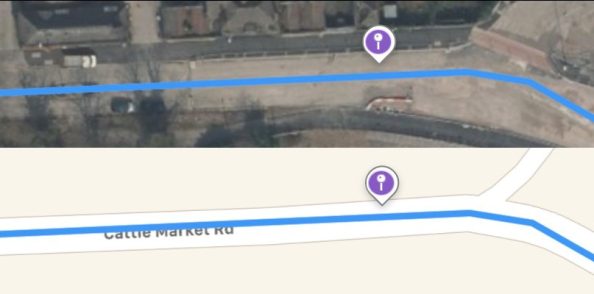
Example Four
Issue Lat/Lng: 51.44848,-2.578491
Screenshot |
|
Explanation | This route is traveling westward (the user would enter on the right and drive toward the left in this screenshot). On satellite, we can see that this looks a little odd. Where the blue line is drawn does not appear to be road but rather bare concrete or some other non-road surface. There is a road just above it, but it’s quite thin and, from the vehicle we can see on the road, appears to potentially be only one-way. Even though this error does not occur at a step change, seeing oddities like this prompt a more thorough investigation. You should drop a pin on the suspicious area and get coordinates to perform research using alternate sources and, if available, review street imagery. Reviewing this area shows that our route was originally navigating along Feeder Rd, however, at some point Feeder Rd went under construction. More recent satellite and street imagery show that to continue in this direction the route would require the user to continue onto “Cattle Market Rd”, however, there are clear signs showing no-entry in that direction. Cattle Market Rd is a one-way street that only travels in the opposite direction. Because our route, as followed, would cause a user to think they should navigate the wrong way down Cattle Market Rd, it should be marked as Against Traffic. |
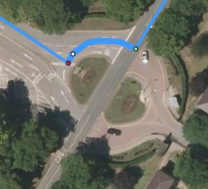
Example Five
Issue Lat/Lng: 51.612819,-1.086906
Screenshot | Explanation |
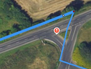
| This route enters the roundabout from the north and instructs the user to turn right (west) into the roundabout. From the satellite layer provided in TryRating, we can see that this roundabout does not travel in that direction. This can be further confirmed with alternate sources. As we have instructed the user to make an illegal turn that takes them against the flow of traffic, this error should be rated as an Against Traffic MNE. See section Choosing Between Multiple MNE Types for additional information on how to select between cases when Multiple MNEs apply at once. |
Example Six
Issue Lat/Lng: -35.020773,117.884092
Screenshot | Explanation |
| This route ends by making a left turn into a shopping center parking lot. Any time a turn is made, research should be performed to ensure that the specific turn is legal. |
Screenshot | Explanation |
| Examining this parking lot in the Satellite Layer, we can see that there are arrows indicating the expected flow of the direction of traffic. They are magnified in the screenshot on the left. Based on the arrows, the parking lot expects drivers to enter from the northeast and proceed southwest. The route given is most likely using an exit-only area to enter the parking lot. There is also a “No Entry” sign that is visible at this area when reviewing street level imagery. With this in mind, this is best fit for a rating of “Against Traffic”. It is physically possible to make this maneuver. The sign indicating “No Entry” isn’t indicating that access to their area allowed but rather that this road is meant for exiting vehicles. |
4.6. Illegal U-Turn
A route has an Illegal U-Turn when we instruct the user to make a U-Turn where no U-Turn is allowed. Laws controlling U-Turns can vary widely by area. We expect that you may need to take some time to familiarize yourself with these before or while reviewing routes.
In many areas, U-Turns are allowed at divided intersections except where prohibited by signage. For these areas, it will be very important to try to find street imagery for the intersection to discover any sign that may prohibit U-Turns. The sign to the right is a common No U-Turn sign used in the United States. In other areas, U-Turns may be prohibited by default except for where allowed by sign, in which case, you should attempt to find street imagery to determine if a sign allowing U-Turns is posted for those areas.
In some cases, rather than asking the driver to make a U-turn, the route’s step-by-step directions may indicate two consecutive turns. As long as the end result is that the user is effectively required to make a U-turn, we should apply U-Turn laws and mark as illegal U-Turn if the turn is not allowed.

Some routes may begin with a U-Turn, as seen in the screenshot above. These cases should also be validated for whether or not a U-Turn is legal at that spot. In these cases, we should assume a driver was navigating from the opposite direction and will be making a U-Turn approximately at the start of the route.
4.6.1. Illegal U-Turn Examples
Example One
Screenshot |
|
Explanation | This route performs two consecutive left turns. The maneuver, as displayed and when performed in real life will be the same as a U-Turn. Even though the step guidance indicates the step is two left turns, if the reality of a maneuver is that it is actually a U-Turn, then U-Turn laws should be applied. If the U-Turn is not allowed at that point, a rating of Illegal U-Turn should be given for the maneuver. |
Example Two
Issue Lat/Lng: 38.700022,-121.290316
Screenshot | Explanation |
| This US route asks us to make a U-Turn from a left turn lane. However, this particular left turn lane does not leave much space for making a U-Turn and these types of lanes often restrict those maneuvers. Seeing a turn like this merits extra attention. We should use a combination of local law research and street imagery services to see if we can find a law or signage that would prohibit this turn. Using a street imagery service, we can see a No U-Turn sign at this turn. As such, this should be rated as an MNE with Illegal U-Turn selected. |
4.7. Turn Restriction
A Turn Restriction error should be indicated when the route has asked you to make a turn that is physically possible but disallowed by signage or other restrictions. In some cases, this may be a limitation by vehicle type (bus-only turn lanes), time of day (left turn restrictions on busy roads during rush hour) or permanent turn restrictions (no left turn signs). If the Turn Restriction is only applied during the time of day, you should use the route timestamp and (if available) step lengths to estimate how long it would take to arrive at the step. In most cases, discovering a turn restriction will require the use of street imagery.
The route timestamp should only be used to determine time of day and day of week restrictions. You should still consider the route to be evaluated in the context of the current day ground truth road network. For example, if a route timestamp indicates the route was requested on Thursday
2016-03-04 at 16:04:35, we should not consider whether the roads being used had a different layout in 2016. We should only consider if there are any turn restrictions that apply at 16:04 on Thursdays or the time it would be when the user reaches that step.
4.7.1. Turn Restriction Examples
Example One
Screenshot |
|
Explanation | The guidance for the last step indicates a final left turn at latitude/longitude: 45.418278,-75.651953. A close examination of the blue line in the route above, confirms that the route does make a final left turn at the intersection. While the distance from the left turn to the end of route is very short, we still need to validate that is is legal and safe to make the turn. This route is from the Canada. Typically, for an intersection of this size in Canada, we would expect to see arrows indicating which lanes are allowed to turn. However, the only road marking visible is a diamond. In the Canada, diamonds indicate “High Occupancy Vehicle” or carpooling lanes. The lack of arrows indicating turn lanes is suspicious and could indicate that a left turn at this lane is not allowed. Following up using street imagery services clarifies that left turns are prohibited at this intersection. As signage confirms this turn is illegal to make, it should receive a Turn Restriction MNE rating. |
Example Two
Screenshot |
|
Explanation | In some cases, turn restrictions may be less explicit and rely on simple knowledge of road rules and driving safety. In the above case, a user has requested a route has the user make three back-to-back left turns in order to proceed east. This type of turn may be acceptable in a truly divided intersection, where cars have an opportunity to stop and wait at each left turn required. It would also be acceptable if this intersection was actually a roundabout that had been visualized poorly. If this were a roundabout, the step directions given to the driver would be a bit silly but the overall intent of the instructions and blue line would be followable. However, this is a standard 4-way intersection. There is little expectation that a 270-degree turn is allowable, legal, or safe in an intersection like this. A case like this should be rated Turn Restriction even though no sign explicitly forbids 270-degree turns. |
4.8. Other
When you notice the route performing a maneuver that is illegal but does not fit into the other MNE categories, you should apply a rating of Other. When rating Other, make sure that you provide a detailed comment thoroughly explaining the issue and how it violates the law.
4.8.1. Other Examples
Example One
Screenshot | Explanation |
| The green origin pin’s location implies the the route is being requested from within a tunnel. A user requesting this route will likely not be able to use it as they are within the tunnel and we have given them a route that starts both above and past the point they’ve already driven. However, we do not consider Origin Pin/Route Starting Location mismatches to be a Major Navigational Error in this test. This should not be indicated as an MNE. Because this has not caused any illegal or unsafe behavior, we should not classify this as an Other MNE. |
5. Choosing Between Multiple MNE Options
You may only indicate a single MNE option when rating in the MNE Driving Routing evaluation. The MNE selected should be for the first MNE found in the route and, if multiple MNEs apply in a single location, should reflect the most severe error.
The following sections discuss several common scenarios where multiple Major Navigational Errors may apply at once.
5.1. Illegal Turn on to a One-Way Road
In some cases, your route may illegally turn onto a one-way road going the wrong direction. In this case, you should select Against Traffic rather than Turn Restriction.
5.2. Illegal U-Turns
While Illegal U-Turns are also a Turn Restriction, only the MNE option Illegal U-Turn should be selected.
5.3. Non-Car Lanes on One-Way Streets
In some areas, one-way streets may exist with an exception given to a bus lane that travels in the opposing direction. If the route were to navigate onto a one-way road like this, we should consider it Against Traffic rather than a Cars Not Allowed restriction for the bus lane usage.
6. How to Review a Route
6.1. Inch-by-Inch
The best way to spot errors in a route is to follow the route from start to finish while reviewing it using the Satellite layer and regularly comparing to multiple alternate sources.
As you do this, you can keep an eye out for things like:
Minor road work (repaving, laying underground wiring and pipes, etc.) should be assumed to not alter the road network and does not merit a rating of MNE.
6.2. Deep Dive on Step Changes and Suspicious Locations
Remember, the goal of this task is not to just identify differences between the route line and what is visible on a satellite layer but rather to try and understand if our route is reflective of the road’s true layout (ground truth). One of the best ways to understand the ground truth is to look for recent, streetlevel pictures of the road. The best sources of this imagery will be street imagery/street view services. Using these to actually see the road, as a user on the ground sees the road, can help you better understand the ground truth of the road. You are not limited to using only street imagery services as an additional source of information. Any photograph of the road, such as those on image hosting or business review websites, can be used as long as the imagery helps you understand the road’s geometry.
Similarly, in some cases, it can help to consult POI maps. For example, if our route navigates into a university or a mall and you have concerns that our satellite imagery and standard map are out of date, quickly looking to see if the university or mall offers a visitor map can be useful in helping to determine if the roads we route on exist as shown.
This sort of research is not required for all portions of the map. However, you should examine any area that looks suspicious from your inch-by-inch review as well as all step changes, as satellite imagery alone is often not sufficient to find issues with turn and access restrictions. R
6.3. Using In Task Street Imagery
In areas where street imagery is available directly in the tool, the Look Around icon will appear in the map toolbar. For these areas, the map will typically load with the current viewport’s imagery locations pre-fetched and the Look Around tool already open.
The Look Around
toolbar has four tools:
Tool Name | Icon | Description |
Hide Collection Points | Hides all fetched clickable panoramic street imagery points. | |
Set Zoom |
| Sets zoom to level necessary to fetch panoramic street imagery. |
Delete All & Reset | Removes all fetched street imagery points | |
Fetch | Gets clickable panoramic street imagery points for the current map viewport. |

The panoramic street image has three tools: the zoom in, zoom out, and full screen image buttons.
To view a panoramic street view image, click on one of the fetched location dots to open the panoramic image. The image to the right shows the task map with clickable, purple street imagery dots. Note: Street imagery dots will vary in color. Do not use the color to influence your rating.
These panoramic street images can be clicked on and dragged to rotate to the view.
It’s important to get your bearings and makes sure you understand the viewing orientation of the panoramic image. Compare against the road geometry visible in the map and use context clues in the image to make sure you have a good understanding of the road network.
7. Frequently Asked Questions
Answer: We should not instruct users to do anything illegal. If the route does so and the maneuver does not fit into any of the existing options, you should select Other.
MNE?
Answer: You should not consider the green user location pin when verifying the accuracy and legality of the route.
Answer: If you are unable to find resources that indicate the maneuver at a step change is illegal or impossible and there is no reason to suspect any issues from the satellite and basemap layers available, then we can give that step the benefit of the doubt and rate “No” on the “Does this route have a major navigational error?” question.
Answer: If the route you have evaluated is truly perfect, you do not need to leave a comment. However, it is always useful to comment on any unique aspects of the route that require complex investigation. For example, some routes may navigate on complex overpasses where it can sometimes be hard to follow the blue line on. Commenting on investigating the overpass is very useful information for those reviewing the routes and your ratings, as we can be sure special attention has been paid to a high-risk MNE area.
Answer: “Route has Non-MNE issues” should not be used for routes that are slightly inefficient. However, if the use of the ferry will cause significant delays to other routes or we are using the ferry because we are missing other major roads, this is a good case for the use of “Route has non-MNE Issues”.
Answer: Yes. If there is an existing ferry route that the user could follow the route is allowed to begin on a ferry. Routes that begin on a ferry will usually not have an initial step indicating the route is beginning on a ferry (the advisory notice may still appear). When trying to determine if the route is beginning on a ferry, look at where it connects to land. If the route is not connecting to land at a ferry terminal, it’s almost certainly not a ferry.
Answer: The Standard layer and routes are both created using similar base data and, for a real user, should always align. However, our routes are created using newer and test versions of this map data and, as such, can differ from that Standard layer. We should base our ratings off the blue route line’s misalignments.
Answer: No, you do not need to continue reviewing the route. After you have found a single MNE, you should select the relevant answer choices, provide the necessary latitude/longitude and comments for that MNE, indicate the MNE Step ID and provide any relevant links to research in the Comments field.
Answer: Access restrictions are applied based on the time the user would arrive at the step. As the step instruction is reflective of the maneuver at the end of the step, you will need to add together the expected times for the previous steps and your current step to determine when the user will arrive at that turn. For example, if step id 4 was the left turn, you would add the times from step ids
0 – 4. If the user arrives while the time restriction is in place, it is an MNE – Turn Restriction.
10.Question: The route I am reviewing has step directions in a weird language, should I release the task or rate this as an MNE?
Answer: In these cases, you should do your best to understand the route, using online translation tools as necessary. Remember, the only item in the step list that can lead to an MNE rating is a missing notification indicating that walking is required from that step to finish the route.
8. Region Specific Guidelines
Please use the below list to access region specific guidelines for TryRating tasks. Not all linked regions will have specific guidance for the MNE Driving Routing task.