1. Introduction
Many different types of errors can cause a user to have a substandard driving experience. In this task, we will focus on identifying Turn Restrictions — driving maneuvers that are illegal or impossible for a driver to perform based on local law and/or the real life layout (or “ground truth”).
This document explains how to identify and evaluate turn restrictions using ground truth to determine if any turn restrictions are present.
The information produced from these tasks will be used for evaluation purposes only.
1.1. Turn Restrictions
A Turn Restriction occurs when a turn on a driving route is physically possible but disallowed by signage or other restrictions. Turn restrictions may be:
Turn restrictions may also be:
In this task, you will conduct research to determine whether or not a turn is safe and legal to perform in the real world and identify specific types of turn restrictions. Types of turn restrictions include, but are not limited to:
1.2. The Rating Tool
The web-based Rating Tool is where you will find specific information about each maneuver and where you will record your ratings. It is divided into three sections: Map View, Maneuver Coordinates and Rating Questions.
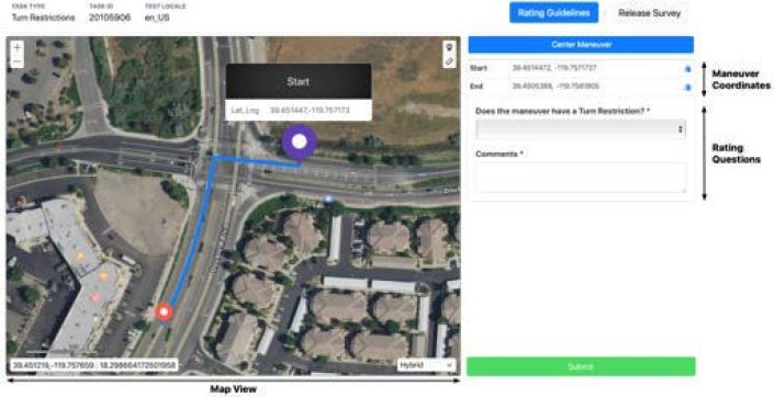
1.2.1. Map View
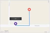
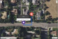
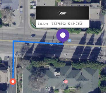
The Map View is located on the left side of the Rating Tool. A blue Route Line indicates a single maneuver between a pair of Start and End Pins. The Pins act as important reference tools to help you understand the maneuver’s direction of movement, as well as to locate the maneuver in reliable online resources. Coordinates for both the Start and End Pins are provided for each maneuver.
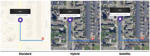
The Map View may be toggled between Standard, Hybrid, and Satellite views. A Map Layer Selector is located in the bottom right corner of the map and allows you to switch between Map Layers.
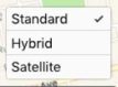
The map will default to the Hybrid View for each task. We recommend that you perform your initial review of the maneuver using the Hybrid view. Hybrid views help you to understand the route’s direction of movement and you may also be able to see road markings, traffic directions, and physical obstructions that are not visible in standard and/or satellite views.
Discrepancies Between Map Layers
You may encounter slight differences between the road network as it is represented in Standard map view and the digitized street lines in Hybrid view. If there are discrepancies in the road network, digitized street lines, or blue route line between map layers, conduct research using reliable online resources to determine the real world environment for the maneuver.
Scree | nshots | Explanation |
|
| For example, this route appears to turn left where there is no road in the standard layer. However, the hybrid and satellite views clearly show that there is a road at this location. By comparing the road network at this location against other reliable online sources, it is possible to verify that the road exists and that there is no turn restriction. |
1.2.2. Digitized Street Lines
This task is focussed on individual maneuvers that are routed according to street lines that are digitized into the map. Digitized Street Lines represent the navigable road network and are only visible in the hybrid map layer. For this reason, the hybrid map view has been selected as the default layer in the Rating Tool.
The table below compares the standard and hybrid map views and illustrates the attributes of digitized street lines.
Screenshots and Explanations | |
Standard Map View | Hybrid View with Digitized Street Lines |
|
|
The Standard Map View displays road networks as yellow or white lines against the map background. One-way roads will include arrows to indicate the direction of traffic. | The Hybrid View superimposes digitized street lines over satellite imagery. Digitized street Lines are labelled with street names and are colored according to the size and class of the associated street/highway. |
 If traffic is moving in a single direction, such as on a one-way street, arrows on the digitized street lines will indicate the direction of traffic (yellow circles).
If the digitized street lines are separated on a divided road/ highway, arrows will indicate the direction of traffic on each side of the divided road.
1.2.3. The Route Line
The blue Route Line follows a segment of a driving navigation route. The blue route line must follow the digitized street lines and obey the direction of movement, whenever indicated.
For each task, you will identify a single maneuver on each route segment and determine if that maneuver has a turn restriction.
Start and End Pins – The route line connects a maneuver’s Start and
End Points. Each point corresponds to a set of geographical coordinates (latitude and longitude) and is marked by a colored Pin. Start and End Pins provide points of reference to help you locate and evaluate individual maneuvers.
Direction of Travel – Each route moves along the blue route line in a single direction, from the purple Start Pin to the red End Pin. Before evaluating a turn, always establish the direction of travel along the route.

Establishing the correct direction of travel is a critical first step for each task. Misreading the correct direction of travel could result in a misidentified turn and/or turn restriction (for example, a left turn being evaluated as a right turn). This is because traffic laws, right-of-way, signage, and road markings may differ between turn types at the
same intersection (for example, when a left turn is permitted but a right turn at the same intersection is restricted).
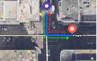
Maneuvers
For each task, you will need to examine a route line and identify a single maneuver to evaluate. Maneuvers may include, but are not limited to:
The following tips will help you to identify the maneuvers that you will evaluate:
Screenshots | Explanation | |
| Start Coordinates | 41.4130, 2.1531 |
End Coordinates | 41.4136, 2.1534 | |
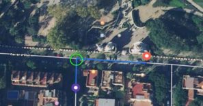
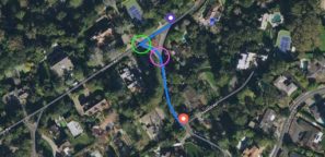
Identify the point at which the route line turns from one street to another. | ||
| Start Coordinates | 37.5549, -122.3462 |
End Coordinates | 37.5539, -122.3462 | |
If a route segments passes through more than one intersection and appears to have more than one turn (green/purple circles), identify the point where the street name changes (green circle). | ||
| Start Coordinates | 47.4676, -122.2182 |
End Coordinates | 47.4673, -122.2164 | |
Identify the point where the route line enters a turn channel or entrance/exit ramp. | ||
| Start Coordinates | 47.4673, -122.2195 |
End Coordinates | 47.4677, -122.2174 | |
Identify the point where the route line merges from a turn channel or entrance/exit ramp onto another road. | ||
| Start Coordinates | 36.0132, -115.1380 |
End Coordinates | 36.0134, -115.1379 | |
Identify the point at which the route line changes direction. Note: U-Turns follow digitized street lines through an intersection and will frequently appear to contain two turns. This is expected behavior and is explained in the following section on Divided Roads, as well as the chapter on U-Turns. | ||

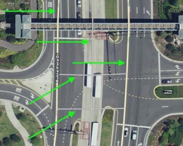
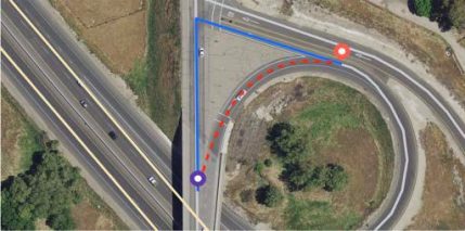
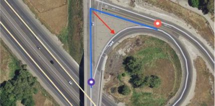
 Divided Roads
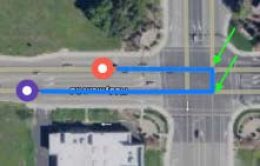
Divided Roads may result in complex intersections of street lines, producing route segments that appear to have more than one turn.
This will often happen when a U-Turn is located on a divided road. For example, this U-Turn begins on one side of a divided road and makes two left turns (green arrows) in an intersection. This behavior is expected and is a result of the route’s alignment with the street lines.
For example, the blue route line ( right) enters the intersection and crosses a digitized street line before initiating a left turn and reversing direction to complete the U-Turn.
This is expected because each of the digitized street lines for this divided road move in only one direction and the route proceeds to the digitized street line that is moving in the correct direction for the short segment of the U-Turn.
Always confirm that the blue route line is traveling in the correct direction, according to the direction of the digitized street lines in addition to the normal direction of traffic, directional arrows, and local laws, etc.
Divided Roads
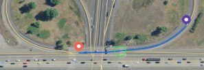
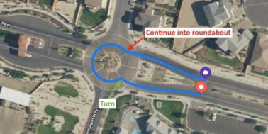
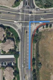
Roundabouts and Traffic Circles
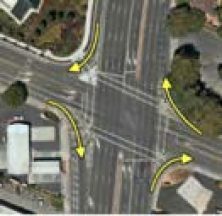
Roundabouts are circular intersections where traffic flows in a single, circular direction around a center point. In regions that drive on the right side of the road, traffic in the roundabout will travel in a counterclockwise direction (left-hand drive locales will travel clockwise). Drivers yield to traffic already in the roundabout before being able to enter. After entering the roundabout, they drive around the center point until they reach an exit point for the road that they wish to travel on.
When a blue route line includes a roundabout intersection, you will need to identify both the the point where the driver would enter and exit the roundabout and evaluate both of those points for turn restrictions.
Screenshot | Explanation |
| In this example, the route begins on a single street, enters a roundabout, and then exits the roundabout at the fourth exit. The points where the route line enters and exits the roundabout are labeled in the screenshot (left). Both points should be examined for any potential turn restrictions. If either point has a turn restriction, record it in your ratings and explain the reason and location of the restriction in the comments field. |
1.2.3. Maneuver Coordinates
Maneuver Coordinates are located in the upper right corner of the Rating Tool. Coordinates will help you to find the maneuver location in reliable online resources:
1.2.4. Rating Questions
The Turn Restrictions task asks for three types of information:
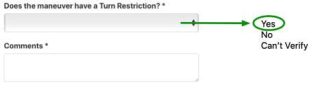
Your ratings and comments will be collected in the Rating Questions section, found in the lower right corner of the Rating Tool. You will answer one result-level questions and provide any necessary notes in the comments field. The result-level question requires a Yes/No response:
• Does the maneuver have a Turn Restriction?
If you respond Yes, a checkbox list of error types will appear. Check the appropriate box and leave a comment to explain the error. In cases where multiple types of turn
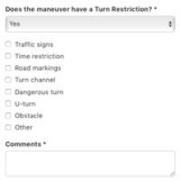
restrictions apply to the same maneuver, check each of the relevant turn restriction types.
Exception: If you select Time Restriction or Other, do not select any other turn restriction type from the list (see Sec. 2.3 – Time Restriction).
2. Rating Process
In this task you will examine individual routing maneuvers and determine if any turn restrictions are present. Whenever a turn restriction is found, you will record the type of turn restriction that is present and provide comments indicating the reasons for your rating.
2.1. Turn Restriction Rating Options
For each task, you will first answer the question, Does the maneuver have a turn restriction?
To answer this question, conduct research by reviewing local traffic laws, by using the map layers in the Rating Tool, and by referencing reliable online resources. You should always review any available street-level imagery of the maneuver in order to understand each maneuver’s real world legal and safety conditions. This is because certain types of turn restrictions may not be visible in hybrid and satellite imagery, such as traffic signs and/or lane markings that are obscured by buildings, trees, and traffic.
Once you have reviewed the maneuver, select one of the following options:
Rating Option | Description |
Yes | It is either unsafe or illegal to turn where indicated in the maneuver. |
No | There is no turn restriction placed on this maneuver. It is safe and legal to conduct this maneuver. |
Can’t Verify | It is not possible to verify the maneuver due to insufficient or otherwise unreliable online information. |
Rating Option | Description |
Traffic signs | The turn is restricted due to rules posted on traffic signs. |
Time restriction | The turn is restricted during particular time of day, d of the week, or season. Usually these restrictions are posted on a traffic sign. |
Road markings | The turn is restricted because it conflicts with painted road markings, such as lane guidance arrows, lane lines, and painted medians. |
Turn channel | The turn deviates from the legal flow of traffic due to the presence of a turn channel. |
Dangerous turn | The turn is restricted because it would be unsafe, such as a dangerously sharp turn. |
U-Turn | U-Turns may be restricted based on local laws, posted restrictions, and inferred restrictions based on ground truth traffic patterns. |
Obstacle | The turn is restricted because a median or curb, etc. physically restricts a maneuver. |
Other | If a turn is illegal or unsafe due to a reason that is not listed above, then select Other and explain why the turn should be restricted in the comments field. |
If you responded Yes, a checklist of possible turn restriction types will appear and you will select each of the restrictions that applies to the maneuver:
2.1.1. Traffic Signs
Traffic signs indicate traffic rules and regulations and warn drivers of potential hazards. Regulatory signs may enforce particular traffic laws or restrict individual maneuvers. For each task, you will need to conduct research to understand if regulatory traffic signs have placed a turn restriction on the maneuver.
Explicit Restrictions
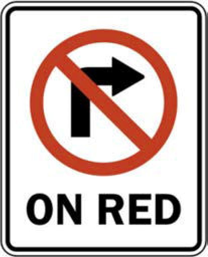
In some cases, regulatory signs will explicitly state a restriction, usually through the use of lane guidance arrows. Some regulatory signs that represent explicit turn restrictions include, but are not limited to, the following examples:
Inferred Restrictions
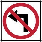
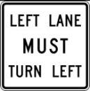
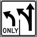
Sometimes, however, turn restrictions must be inferred from traffic signs and based on the actual configuration of lanes and traffic patterns. Some regulatory signs that you may infer turn restrictions from include, but are not limited to, the following:
Inferred Restrictions | |||
|
|
|
|
U-Turn is restricted. | U-Turn is restricted. | All turns are restricted. | Right turn onto the street is restricted when traffic on the street flows in only one direction. |
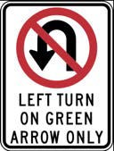
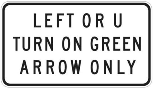
Traffic Rules vs. Restrictions
Some traffic signs will refer to specific turns and maneuvers but should not be considered turn restrictions. For example, a sign that instructs drivers that there are “left turns on green arrow only” indicates a traffic right-of-way rule, but is not intended to permanently restrict or prohibit right turns. Since the turn is not permanently prohibited, you should not rate it as a turn restriction. Some regulatory signs that refer to specific traffic rules, but are not turn restrictions may include, but are not limited to, the following:
2.1.1.1. Examples
Screenshots | Explanation | |
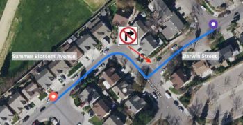
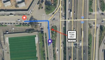
| Start Coordinates | 37.3270483, -121.8423851 |
End Coordinates | 37.3265251, -121.8438228 | |
The route line turns right from Darwin Court to Summer Blossom Avenue. Research reveals that there is a NoRight-Turn sign at this intersection. Because it would not be legal for a driver to turn right against the direction indicated by the traffic sign, this maneuver has a turn restriction due to traffic signs. | ||
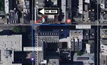
| Start Coordinates | 29.9561, -90.0656 |
End Coordinates | 29.9568, -90.0658 | |
The route line turns right from St. Louis to Royal Street. Research reveals that there is a One Way sign on Royal Street that only allows a left turn. Because it would not be legal for a driver to turn right against the direction indicated by the one-way traffic sign, this maneuver has a turn restriction due to traffic signs. | ||
Screenshots | Explanation | |
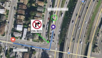
| Start Coordinates | 37.9361, -122.3273 |
End Coordinates | 37.9358, -122.3283 | |
The route line begins on a highway offramp and then turns right onto Barrett Avenue. At the intersection there is a sign which reads, “(No Right) on Red”. This sign indicates a right-of-way traffic rule, but does not prohibit the turn. There are also painted lane arrows (green circle) which indicate that the turn is legal. Since the right turn is not permanently prohibited, this is not a turn restriction. | ||
2.1.2. Time Restriction
Time Restrictions are temporary and may restrict traffic on particular times of the day and/or particular days of the week or months of the year. Time restrictions are usually placed on a maneuver with regulatory traffic signs that indicate which behavior is restricted and which days and/or times the restriction is in place. If a time restriction is placed on a maneuver, select only Time Restrictions. Do not select any other restriction types, including Traffic signs.
2.1.2.1. Examples
Screenshots | Explanation | |
| Start Coordinates | 37.8776, -122.3078 |
End Coordinates | 37.8779, -122.3085 | |
The route line begins on W Frontage Road and turns left at Gilman Street. Research, using street imagery, reveals that there is a sign at this intersection that restricts left turns every weekday from 5-7pm. This is a recurring, temporary restriction and should be rated as a Time restriction. Note: Since temporary restrictions are exceptions to the traffic signage rule, you should not rate this maneuver as having a Traffic signs restriction. | ||
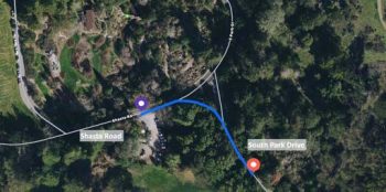
| Start Coordinates | 37.8926, -122.2431 |
End Coordinates | 37.8921, -122.2419 | |
The route line turns right from Shasta Road onto South Park Drive. Research reveals that there is a seasonal restriction: South Park Drive closes annually from Oer to March due to seasonal salamander migration patterns. The road is closed for part of each year and thus has a seasonal Time restriction. | ||
2.1.3. Road Markings
Lane and road markings, including lane lines and arrows, may also be used to enforce traffic rules, right-of-way, and lane control. Always refer to local laws and regulations to understand the legal meanings of different colors and patterns of lane and road markings.
2.1.3.1. Examples
Screenshots | Explanation | |
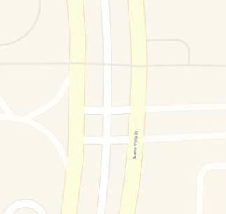
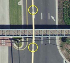
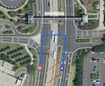
| Start Coordinates | 28.3674, -81.5200 |
End Coordinates | 28.3677, -81.5200 | |
The blue route line begins on Buena Vista Drive and then makes a U-Turn. Research confirms that the maneuver follows the digitized street lines and obeys directional arrows for individual segments. However, the leftmost lanes on Buena Vista Drive have painted arrows that indicate that it is only legal to proceed forward through this intersection. U-Turns, therefore, are not permitted. Because it would not be legal for a driver to make a U-Turn against the direction indicated by lane markings, this maneuver has a turn restriction due to Road markings. | ||
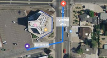
| Start Coordinates | 39.5432526, -119.7532283 |
End Coordinates | 39.5437471, -119.7526857 | |
The blue route line begins on 1st Street and turns left onto a multi-lane road, Pyramid Way. Research, using street imagery, reveals that there are two sets of double-yellow line lane markings on Pyramid Way. This route is located within in the US. Typically, in the US, when two sets of double-yellow lines are spaced 2 feet apart or more, they should be considered to be an impassable barrier. Because it would not be legal for a driver to cross these lane markings, this maneuver has a turn restriction due to Road markings. | ||
Screenshots | Explanation | |
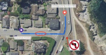
| Start Coordinates | 36.6216066, -121.9133239 |
End Coordinates | 36.6226053, -121.9134615 | |
The route line begins on Carmel Avenue and turns left onto Ocean View Boulevard. Road markings that read, “turn right only”, are obscured by the route line in hybrid and satellite images (red circles), but are clearly visible in street-level imagery from reliable online resources. A traffic sign also restricts a left turn at this intersection. Because this left turn is restricted by road markings and a traffic sign, you should select both Traffic signs and Road markings as the turn restriction types. | ||
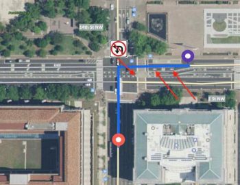
| Start Coordinates | 38.8955, -77.0313 |
End Coordinates | 38.8951, -77.0319 | |
The blue route line begins on E Street NW and turns left onto 14th Street NW. Research, hybrid imagery reveals that the leftmost lanes on E Street have painted arrows that indicate that it is only legal to proceed forward through this intersection, but not turn left. A traffic sign also restricts a left turn at this intersection. Because it would not be legal for a driver to turn left against the direction indicated by lane markings and a traffic sign explicitly restricts a left turn at this intersection, you should select both Traffic signs and Road markings as the turn restriction types. | ||
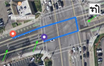
| Start Coordinates | 37.2628, -121.8770 |
End Coordinates | 37.2628, -121.8774 | |
This route line makes a U-Turn on Branham Lane. Research reveals that there are dedicated Left/U-Turn lanes with left arrow road markings. Left turn arrows should not be understood as an inferred u-turn restriction, unless some other reason for the restriction is present. A traffic sign, however, does explicitly allow this maneuver. This U-Turn is safe and legal to perform, so there is No turn restriction. | ||
2.1.4. Turn Channel
A turn channel is any dedicated turn lane with:
 Non-Lane Spaces
A painted non-lane space may appear differently based on the region, road type, and traffic patterns. In this example, painted lines are filled with a chevron pattern to represent spaces that should not be considered part of the legal driving lanes.
Examples of Turn Channels | ||
|
|
|
The left turn lane is separated with a non-lane space, so the left lane should be considered a Turn channel. | These are ‘slip lanes’ (yellow arrows), a type of Turn channel that allows drivers to bypass an intersection and merge into traffic without having to yield to oncoming traffic. | Highway/interstate ramps are also considered to be Turn channels, since physical or painted dividers separate traffic that is exiting or entering the highway. However, in most cases, a forking road or splitting highway will not be considered a turn channel. |
Do not consider a lane(s) to be a turn channel if it is separated from other lanes by:
• a single solid white line, as this does not create a non-lane space between the other lanes. • a bike-only or bus-only lane. For this evaluation, these are considered lanes and not a non-lane space.
Examples of Lanes that are NOT Turn Channels | ||
|
|
|
The left turn lanes are separated by a single, solid white line. Standard turn lanes are not turn channels. | The right turn lane is separated by only a bike lane. Bike and bus lanes are not considered to be non-lane spaces, so this is not a turn channel. | The highway split contains a nonlane space; however, this is not a turn lane and therefore is not a turn channel. |
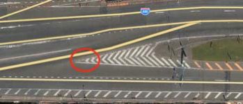
Whenever you evaluate a turn channel, you will need to compare ground truth imagery with the existing street lines that are visible in hybrid map views. This is because there will not always be individual street lines running through turn channels. The absence of street lines for a turn channel may cause the route line to perform a typical turn at an intersection, rather than following ground truth through the turn channel.
|
|
At this intersection the digitized street lines do not follow the dedicated left turn channel. As a result, the route does not follow the ground truth path, but moves into the intersection before making the left turn. | Again, the street lines do not follow the dedicated right turn channel. As a result, the route does not follow the ground truth path, but moves into the intersection before making the right turn.
|
If the blue line does not use the turn channel and instead shows a typical turn, you should rate the maneuver as having a Turn channel restriction. Keep the following rules in mind when determining if a turn channel restriction is present:
1. If a turn channel exists, but the digitized street lines in hybrid imagery and the blue route line do not travel along this path, then rate the maneuver as having a Turn channel restriction. |
|
2. If a turn channel exists and there is also a specific digitized street line for that turn channel, but the blue route line does not follow this path, then the maneuver has a Turn channel restriction. |
|
3. If the blue route line follows an existing turn channel along a valid digitized street line, the maneuver does not have a turn restriction. |
|

2.1.4.1. Examples
Screenshots | Explanation | |
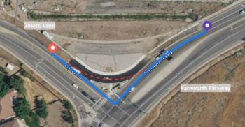
| Start Coordinates | 39.4183285, -119.7581933 |
End Coordinates | 39.4181753, -119.7595639 | |
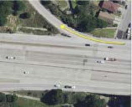
The route line begins on Farnworth Parkway and turns right onto Zolezzi Lane. A turn channel (red dashed line) is visible in hybrid view but there is no digitized street line for the turn channel. Research reveals that this is a valid and active turn channel and should be used, rather than proceeding to the intersection to turn right. This route has a Turn channel restriction. | ||
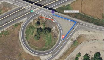
| Start Coordinates | 36.2974523, -119.7545086 |
End Coordinates | 36.2969424, -119.7543136 | |
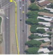
The route line begins on Houston Avenue and turns right onto a highway onramp. A turn channel with a dedicated digitized street line is visible in hybrid view. Research reveals that this is a valid and active turn channel and should be used, rather than proceeding to the intersection to turn right. This route has a Turn channel restriction. | ||
| Start Coordinates | 37.6296469, -120.9230394 |
End Coordinates | 37.629136, -120.9240295 | |
The route begins on Garner Road and turns right onto Leckron Road. A turn channel exists (note the non-lane space created by the road markings), but does not have a digitized street line. Instead, the route proceeds to the intersection and makes a 90° turn. Since this turn conflicts with the turn channel, the maneuver has a Turn channel restriction. | ||

2.1.5. Dangerous Turn
Dangerous turns are determined as a combination of local laws and ground truth conditions. When judging if a turn is dangerous, take into consideration traffic speed, visibility of traffic (i.e. is traffic obscured by a nearby bend in the road?), narrowness of the roads, and any other obstacle that may make the maneuver dangerous to perform.
Roads with sharp turns should not be allowed in the following situations:
Note: In some instances, sharp turns may not be considered to be dangerous if they are located on low speed limit roads (30mph or under). For example, a sharp turn located within a residential neighborhood on roads with low speed limits may be considered to be safe and legal, if there are no other reasons for the turn to be restricted.
2.1.5.1. Examples
Screenshots | Explanation | |
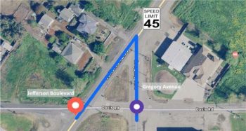
| Start Coordinates | 38.5322, -121.5560 |
End Coordinates | 38.5322, -121.5564 | |
The route line begins on Gregory Avenue and then turns left sharply onto Jefferson Boulevard. Research reveals that Jefferson Boulevard has a speed limit of 45mph. Because the turn is too sharp and would turn onto a high speed limit road, it should be rated as a Dangerous turn. | ||
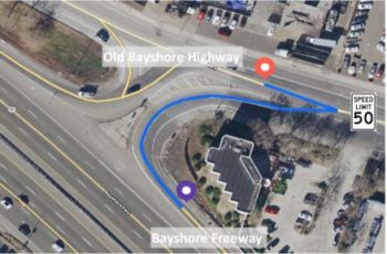
| Start Coordinates | 37.3682, -121.9078 |
End Coordinates | 37.3689, -121.9078 | |
The route line begins on an exit ramp from Bayshore Freeway and then turns left sharply, rather than merging with Old Bayshore Highway. Research, including knowledge of local traffic laws, also reveals that Old Bayshore Highway has a speed limit of 50mph. Because the turn travels against the expected flow of traffic and would turn sharply onto a high speed limit road, it should be rated as a Dangerous turn. | ||
Screenshots | Explanation | |
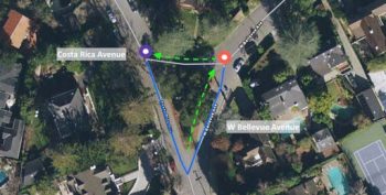
| Start Coordinates | 37.5666, -122.3461 |
End Coordinates | 37.5665, -122.3458 | |
The route line begins on Costa Rica Avenue, a low speed limit residential road, and then turns very sharply onto West Bellevue Avenue. However, research reveals that West Bellevue Avenue is split into two, one-way segments (green arrows) and the turn follows the legal flow of traffic. Since this turn is located in a residential neighborhood on low speed limit roads and there are no other obstacles present, this would not be considered a dangerous turn. | ||
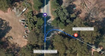
| Start Coordinates | 37.4051, -122.4204 |
End Coordinates | 37.4048, -122.4196 | |
The route line begins on Cabrillo Highway South, a high speed limit road, and then turns very sharply onto Purisima Creek Road. However, research reveals that the street lines do not accurately represent the ground truth angle of this turn; a driver would not need to perform a sharp turn here. There is also a dedicated left turn lane on Cabrillo Highway, so this would not be considered a dangerous turn. | ||
2.1.6. U-Turn
A U-Turn occurs when a route makes a u-shaped maneuver and reverses direction by 180° to travel in the opposite direction on the same street that the maneuver originated on. A maneuver should be rated as U-Turn whenever a U-Turn is not safe or legal to perform.
Laws controlling U-Turns can vary widely by area. You may need to take some time to familiarize yourself with the relevant traffic laws for the locale that you are evaluating. In many areas, U-Turns are allowed at divided intersections except where prohibited by signage. For these areas, it will be very important to establish the ground truth for the intersection to discover any sign that may prohibit UTurns. In other areas, U-Turns may be prohibited by default, except where they are allowed by sign. In those cases, you should attempt find street-level imagery to determine if a sign allowing U-Turns is posted for those areas.
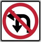
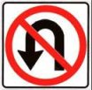
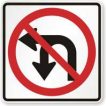
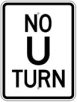
The signs below are common ‘No U-Turn’ signs that are used in the United States:
|
|
|
2.1.6.1. Inferred U-Turn Restrictions
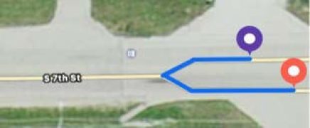
1. A single-lane to a single-lane road, including within residential neighborhoods. | Start Coordinates | 41.9074, -89.0684 |
End Coordinates | 41.9075, -89.0685 | |
| ||
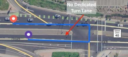
2. High speed limit roads (over 30mph) that do not have dedicated turn lanes. | Start Coordinates | 38.5500, -121.4279 |
End Coordinates | 38.5501, -121.4277 | |
| ||
3. Divided roads that do not have dedicated turn lanes. Divided Roads separate the directions of traffic with a central median or other non-lane space. | Start Coordinates | 38.5526, -121.4278 |
End Coordinates | 38.5526, -121.4279 | |
| ||
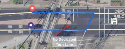
In addition to local laws, some U-Turns are inferred to be illegal. Unless a U-Turn is explicitly permitted, U-Turns should be restricted in the following situations:
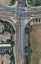
‘Next Intersection’ Rule
U-Turns are also inferred to be restricted whenever a displayed maneuver lacks a dedicated Left/UTurn lane and the intersection immediately following a displayed maneuver does have dedicated turn lanes. In other words, because the following intersection has dedicated turn lanes, we presume that that intersection is the preferred location to execute the U-Turn.
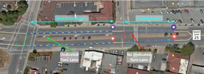
For example, to rate the ‘test maneuver’ (above, right), first establish ground truth for the driving route. Research reveals that there are no traffic signs or road markings that restrict U-Turns and the speed limit in this area is 25mph.
As a result, the U-Turn in the ‘test maneuver’ may at first appear to be safe and legal. However, because there is a dedicated Left/U-Turn lane at the ‘next intersection’, we infer that the U-Turn for the ‘test maneuver’ is restricted.
Note: The ‘next intersection’ rule applies exclusively to the intersection immediately following the displayed test maneuver. Do not base your rating on the intersection that immediately precedes the test maneuver.
2.1.6.2. Examples
Screenshots | Explanation | |
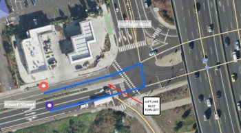
| Start Coordinates | 37.8378,-122.2979 |
End Coordinates | 37.8377, -122.2979 | |
The route line begins on Powell Street and makes a U-Turn at the intersection with Frontage Road. Research, using street imagery, reveals that there is a turn restriction at this location. A traffic sign states that traffic in the left lane must turn left. Because the U-Turn restriction is defined by a traffic sign, you should select both Traffic signs and UTurn as the turn restriction types. | ||
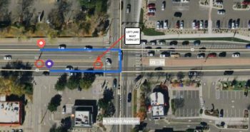
| Start Coordinates | 40.407231, -105.073788 |
End Coordinates | 40.4073, -105.0738 | |
The route line begins on US-34 and makes a U-Turn at the intersection with North Lincoln Avenue. Road markings (red circles) designate this as a left turn only lane. A traffic sign also states that traffic in the left lane must turn left. Because the U-Turn restriction is defined by road markings and a traffic sign, you should select Traffic signs, Road markings, and U-Turn as the turn restriction types. | ||
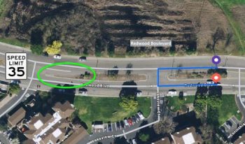
| Start Coordinates | 38.0885, -122.5569 |
End Coordinates | 38.0884, -122.5569 | |
This route begins on Redwood Boulevard and reverses direction to make a U-Turn after a traffic island. Research reveals that the location of the maneuver does not have a dedicated turn lane and the speed limit is 35mph. There is, however, a dedicated turn lane at the next intersection, so this may be inferred to be a U-Turn restriction, according to the ‘next intersection’ rule, even though there are no traffic signs or lane markings to explicitly restrict the maneuver. | ||
2.1.7. Obstacle
If a turn would require a driver to drive through or over a physical obstruction, the turn is restricted. Physical obstructions may include, but are not limited to:
2.1.7.1. Examples
Screenshots | Explanation | |
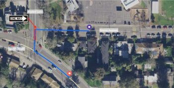
| Start Coordinates | 38.4516393, -122.6967201 |
End Coordinates | 38.4507763, -122.696763 | |
The route line turns left from Grosse Avenue to Bryden Lane and Fourth Street. Research, using street imagery, reveals that there is a One Way sign at Bryden Lane that only allows a right turn as well as a physical median that makes the maneuver impossible (red rectangle). Because it would not be possible for a driver to turn left due to the physical median, this maneuver has a turn restriction due to the Obstacle. | ||
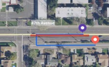
| Start Coordinates | 38.5105, -121.4446 |
End Coordinates | 38.5103, -121.4445 | |
The route begins on 47th Avenue and then turns left onto a small road that is immediately adjacent to 47th Avenue. Research reveals that there is a painted median with raised bricks in the turn lane (red rectangle). Because it would not be legal or possible for a driver to conduct this maneuver, the U-Turn is restricted due to the Obstacle. | ||
2.1.8. Other
If a turn is restricted, unsafe, or illegal due to a reason that is not listed in the previous sections, then select Other and explain why the turn should be restricted in the comments field. Some reasons that a maneuver m be rated Other include, but are not limited to:
2.1.9. Can’t Verify
Can’t Verify should be reserved for cases when it is not possible to verify the maneuver due to insufficient or unreliable online information. For example, this task requires that you conduct research using a minimum of hybrid and street imagery to understand and evaluate the ground truth of individual maneuvers. If street imagery for a particular maneuver is not available from any reliable online resources, you should rate Can’t Verify and explain the issue in the Comments field.
2.2. Comments
Comments are mandatory anytime that you respond Yes or Can’t Verify. Use the comments field to explain why the turn should be restricted and any research that influenced your ratings. Be sure to:
In some cases, it is helpful to leave a comment even when a turn restriction is not present. If you respond No, but any of the following are present, please leave a comment:
The following sections provide further details and examples for cases where a turn restriction is not present, but a comment should be provided.
2.2.1. Traffic Signs or Road Markings
Traffic signs and road markings are not always restrictive. Sometimes they will explicitly allow a maneuver. If a displayed maneuver is explicitly allowed by either a traffic sign or road marking, please add a brief comment. For example, ‘turn allowed by traffic sign’.
2.2.1.1. Example
Screenshot | Explanation | |
| Start Coordinates | 38.6870, -121.1240 |
End Coordinates | 38.6870, -121.1241 | |
At this intersection, the route line makes a U-Turn. Research, using hybrid and street imagery, reveals that there is a dedicated turn lane as well as a sign which explicitly allows the U-Turn at this intersection. Since the turns is explicitly allowed, rate No to confirm that there is not a turn restriction present and leave a comment indicating the presence of the traffic sign (e.g. ‘u-turn | ||
allowed by traffic sign’). | ||

2.2.2. Poor Digitization of Street Lines
The digitized street lines may not always reflect the ground truth of a user’s experience. Large highways or divided roads with directions of traffic separated by walls or median islands will often have separate digitized street lines representing each direction of traffic. However, when divided roads/highways change in size or configuration, this may cause the digitized street lines to converge.
When digitized street lines converge, the result is called a pinch maneuver, a specific type of digitization configuration.

This is expected behavior and does not independently qualify as an error or restriction. Whenever the route line follows an irregular geometry due to the digitized street lines, conduct research to verify the maneuver’s ground truth. If the digitized street lines do not accurately capture the ground truth of a turn, but there is otherwise no turn restriction, please leave a comment. For example, ‘pinch maneuver’ or ‘street digitization issue’.
2.2.2.1. Examples
Screenshot | Explanation | |
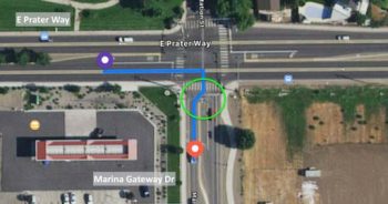
| Start Coordinates | 39.5419, -119.7229 |
End Coordinates | 39.5415, -119.7224 | |
The blue route line turns right from E Prater Way onto Marina Gateway Dr. This is a safe and legal turn, however, the digitized street line just after the turn makes another slight turn following the maneuver. Research, using hybrid and street imagery verifies that this is due to the separation of the digitized street lines in the map and does not reflect user ground truth. Since there is No turn restriction and a digitization issue is present, leave a comment (e.g. ‘digitization issue’) | ||
Screenshot | Explanation | |
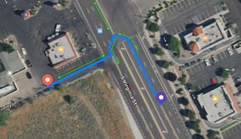
| Start Coordinates | 38.7870, -121.3006 |
End Coordinates | 38.7873, -121.3026 | |
This route line appears to make a U-Turn in the middle of an intersection and then turn right. Research verifies that there is a legal and safe left turn at this intersection and the U-Turn segment does not reflect the ground truth of this maneuver. However, the blue route line must follow the direction of the digitized street lines (indicated by the arrows). Since the route line cannot turn left against the direction of the street line at the beginning of the intersection, it travels in the correct direction along each street line to make a legal left turn. Research also reveals that there is a dedicated left turn lane with road markings and a traffic sign that explicitly allows the left turn and restricts a U-Turn. Since the ground truth of this maneuver does not actually include a U-Turn, we may disregard the posted U-Turn restriction. For this example, rate No and leave a comment (e.g. ‘poor digitization, U-Turn segment unnecessary. turn is allowed by traffic sign’). | ||
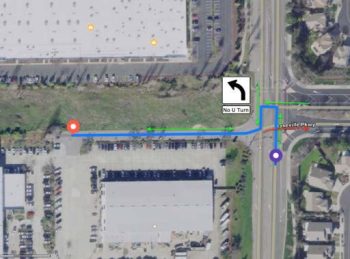
| Start Coordinates | 39.4210, -119.7578 |
End Coordinates | 39.4211, -119.7587 | |
This example includes a pinch maneuver at the point of the apparent U-Turn. Research reveals that this is a legal left turn, including a dedicated turn lane with road markings, and that the U-Turn is not necessary. Since there is no turn restriction and the irregular geometry is a product of the digitization of street lines and not of the ground truth at this intersection, rate No and leave a comment indicating that a pinch maneuver is present (e.g. ‘pinch maneuver creates unnecessary UTurn. maneuver is allowed by left turn lane markings’). | ||
| Start Coordinates | 39.5275, -119.8643 |
End Coordinates | 39.5276, -119.8639 | |
This route line does not appear to contain a maneuver, but there are issues with the digitization of the street lines. For this example, rate No and leave a comment (e.g. ‘no maneuver and poor digitization due to pinch maneuvers’). | ||

2.2.3. Temporary Closures
Temporary closures or detours for construction, special events, etc., are not considered to be turn restrictions. If these are present, please make a note and explain how these circumstances influenced your rating. Generally, temporary construction should not constitute a turn restriction and should be rated according to the permanent ground truth. Conduct research using reliable sources to establish ground truth and rate accordingly.
However, if no reliable online resources are available and you are unable to establish the permanent ground truth of a maneuver, you should rate Can’t Verify and explain the issue in the Comments field.
Note: Temporary closures differ from time restrictions because temporary closures are not expected to occur again at a particular location. Unlike time restrictions, temporary closures will not usually have permanent signage.
3. FAQ
If multiple sources have conflicting information, attempt to determine which source provides the most recent representation of ground truth. You may be able to infer some information based on a comparison of sources. For example, if satellite and street imagery from one source show an intersection under construction, but construction of the intersection has been completed in imagery from another source, then you may reasonably conclude that the latter source is a better, and more recent, representation of the ground truth at that location.
If an area appears to be under construction, such that it would effect the path or accessibility of the route on a permanent basis, confirm with other online resources to verify which information is most current and use the most recent information available as the basis for your evaluation.
If all available resources reflect a site under construction, such that you are unable to determine the ground truth of the maneuver, then rate Can’t Verify and leave an explanation in the Comments field.
Sometimes a route may appear to have more than one maneuver based on the location of nodes in the street lines. This often occurs in intersections where more than two roads intersect, where there are slight offsets in roads where they intersect, and occasionally in U-Turns. In the rare instance that a route line contains more than one turn, evaluate both turns and rate accordingly. Be sure to also leave a comment to explain that there is more than one turn and indicate which, if any, turn has a restriction.
You may select more than one type of Turn Restriction. If a maneuver has multiple turn restrictions, you should select all that apply. For example, if a U-Turn is restricted due to both signage and specific lane markings, you should select both, Traffic signs and ‘road markings’ in addition to U-Turn.
However, there are two exceptions to this rule. You should not select more than one option if you have selected:
Both of these selections are mutually exclusive of all other categories or turn restriction.