1.Helpful Tools
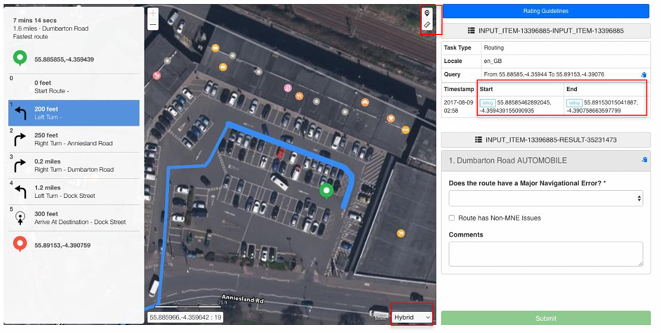
- Select the satellite or hybrid Map View for this task
- Keep a map application (or two) open for “real life” comparison.
- Click on a Step # in the Step List to highlight/bolden that route step in the Map View. (See Step 1 above and the segment closest the green pin.)
- Double click on a Step # to zoom in on that step in the map view.
- Click anywhere on the Map View to enable the “grab” function to pull the map along a segment.
- Use the TryRating Pin Tool to drop a pin at any point on the map to obtain coordinates of any suspect area.
- Use the TryRating Ruler Tool to measure any potential misalignment MNE.
2. General Task Approach (high-level steps)
Task Goal: To locate Major Navigational Errors (MNE) impacting user experience.
The goal is not to find every such error, but to ensure the route is free of all such errors. As soon as the first MNE is found, the route is deemed to provide a poor experience and documentation begins.
1) Check route Start and End points first for MNE. The coordinates for these points can be copied from the rating (left) side of the task interface.
TIP:
MNE such as “Against Traffic” or “Illegal U-Turn” often occur at the start and end. Zoom in at these points and deep dive as needed using street views and/or online imagery.
2) Follow the route from Step 1 “step-by-step” verifying that:
- roads/paths are not off limits to passenger vehicles (Cars Not Allowed),
- travel is not directed in the wrong direction on one-way streets or at POI entrances/exits (Against Traffic),
- routes do not pass/shortcut through private drives or parking lots (Access Restricted),
- and that the blue line is not measured to be more than 50 meters of the
actual road (Major Road Misalignment).
3) Zoom in at turns, route changes, and all suspicious areas checking for:
- illegal turns, including those made at prohibited times of the day (Turn Restriction),
- prohibited U-turns (Illegal U-turn),
- misalignments to turn channels as measured per Routing GL criteria (Major Road Misalignment),
- and potential barriers to entry/turning like curbs, fences etc. (Physically Impossible).
4) Deep dive using map application street views/online imagery in order to see signage, painted markings and the real-world configuration of any suspicious area.
5) Record first MNE and any non-MNE found up to that point by:
- Selecting the matching MNE checkbox,
- Entering the latitude and longitude coordinates of the MNE location,
- Recording comments that include the route step #, a description of the MNE issues and non-MNE oddities with links to supporting images, websites etc
3. Common Errors
- Generally, not taking time to deep-dive verify oddities using street view/imagery
- Not checking for turns restrictions indicated by painted and posted signage
- Not verifying the legality of a U-turn per signage or by checking local/regional law (gov/DMV sites) when signage isn’t visible
- Failing to understand the difference between “Cars Not Allowed” and “Access Restricted”
- Not noticing shortcut through parking lots which are not the route start or
ending points; or using unnamed lanes through shopping centres that are not intended to be used as pass-throughs (Access Restricted). - Failing to check maps for new infrastructure like round-a-bouts etc.
- Assuming dirt roads are not really roads when they are actually used by cars
- Failing to notice barriers (curbs/fences etc.) that block entry/exit to parking areas that should be flagged for as “Physically Impossible”
- Flagging “Access Restricted” when the route ends within a gated area—to which we should assume the driver has access
- Falsely indicating a “Major Navigational Misalignment” when the blue line crosses over to the opposite side for a particular segment of the route which is normal variation
- Not properly identifying turn channel misalignment—which often requires measurement unless obviously short
- Failing to note the Step #, coordinates and describe the issue as required the Comments box.
4. Efficiency Tips
- Checking route start and end first before continuing through the step list is one of the biggest time savers.
- Zooming out on long, straighter-sections (long stretches of highway for example) that have no maneuverers allows you to proceed faster.
- Noting how cars are parked (the windshield direction) can often help you find instances of “Against Traffic” without using street views
- Over-researching/document minor issues can take up time that should be used to focus on MNE. If you happen upon a non-MNE use the “Route has non-MNE” checkbox; but don’t go out of your way looking for these
- Reviewing the entire route after you have found one MNE is wasteful. Once you have found one MNE, document and submit the task.
**Remember, this document is for quick reference purposes only. For specifics on
this task be sure to refer to the specific Routing GL sections and examples contained therein.