Tip: Sometimes you can easily spot a problem area in a task route by requesting the same route in a different map application and quickly comparing the shapes of the routes. Investigate any obvious differences to determine whether they are caused by a Major Navigational Error in the TryRating route. If you find an MNE, you do not need to continue checking the remainder of the route.
1. Physically Impossible
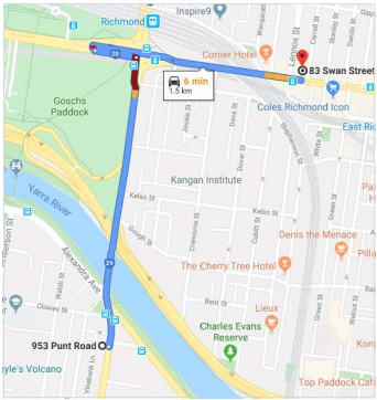
This is an example task route as shown in TryRating Map:
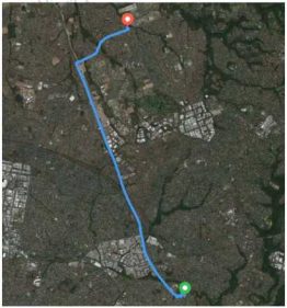
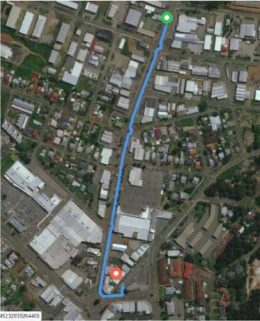
Next, the route is obtained by entering the start and end coordinates from the TryRating task into a different map application and requesting directions.
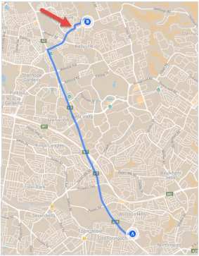
Comparing the routes, we can see that the shape near the end differs. The part of the route near the red arrow is smoother in the TryRating version. We should investigate the reason for the difference.
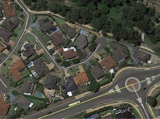
On examining the end of the TryRating route in satellite view, we can see that the user is routed through residential buildings. The TryRating standard map layer shows Samantha Riley Drive connecting to Vivaldi Place, but the other map application does not.
Recent satellite imagery of the location indicates that Samantha Riley Drive does not intersect with Vivaldi Place.
A web search for real estate listings in Vivaldi Place provides another image to confirm this.
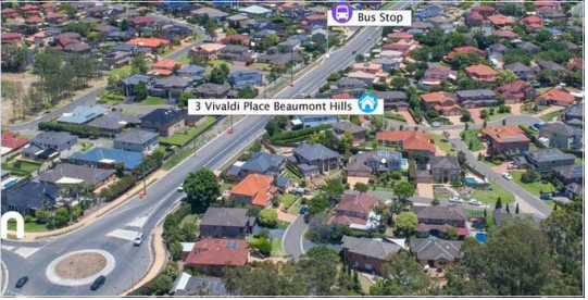
The task route should receive a rating of Physically Impossible for using a road that does not exist and indicating that the user should drive through a building (see Section 4.2 of the MNE Driving Routing Guidelines).
2.Walking Instructions
Sometimes analysts will spot part of a route that looks suspicious, find that the blue line leaves the road and travels along a pedestrian-only path or trail, and then rate the route as having an MNE without checking the Step List.
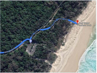
Remember, if the step guidance correctly indicates a pedestrian pathway by
•a step that says “Arrive End of Navigation” with additional steps following or
•a step that says “Prepare to park your car” with additional steps following
then this part of the route should not be considered to have a Cars Not Allowed MNE.
The step guidance text is considered acceptable even if in a foreign language – use online translation tools as necessary.
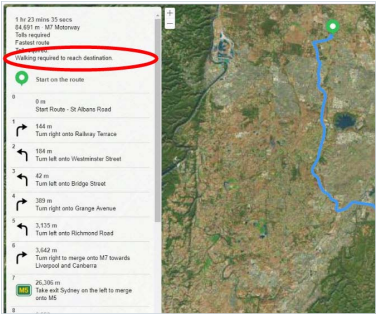
Keep an eye out for an advisory notice indicating that the route requires walking to reach the destination.
U-turns should be checked in street level imagery whenever possible. Sometimes a No U-Turn sign will indicate specific hours/days. This means U- turn restrictions apply at those times only.
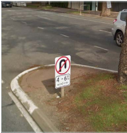
When subject to a sign with time restrictions, use the route timestamp and (if available) step lengths to estimate the time that the user would arrive at the sign. The timestamp should only be used to determine time of day and day of week. Month and year should be ignored and current month/year should be assumed.

In Victoria, U-turns are allowed at intersections with traffic lights unless there is a No U-Turn sign. In all other states/territories U-turns are not allowed at intersections with traffic lights unless there is a sign or light indicating that U- turns are permitted.
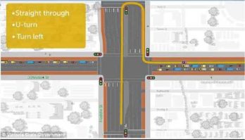
Following is an example task route. The route is fairly simple, but as highlighted in the step list, it contains two U-turns.
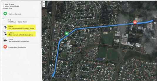
U-turns are potential problem areas, so checking them as a first step may prove fruitful. The first U-turn is at a roundabout at approx. -27.161625, 152.958056. Street imagery at this location doesn’t indicate any safety or legal issues with doing a U-turn here.
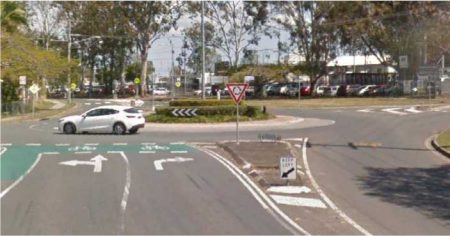
The coordinates of the second U-turn are approx. -27.154374, 152.972728.
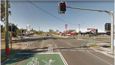
Street imagery at this location indicates the U-turn occurs at traffic lights.
The previous image shows the street view as the user approaches the lights.
The below image is the view after slightly moving into the intersection.
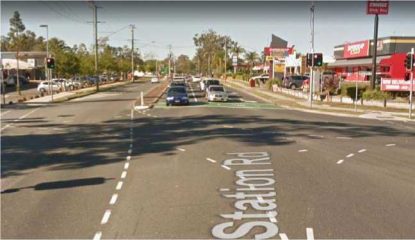
This route is located in QLD, where the road rules state that “You can only make a U-turn at traffic lights when there is a U-turn permitted sign” (source: http://bit.ly/2MXvloC).
.
There is no such sign visible in street imagery, so a U-turn here would be illegal. This step would be rated MNE – Illegal U-Turn (see Section 4.6 of the MNE Driving Routing Guidelines).
Once we have found an MNE, there is no need to spend time investigating the other parts of the route. We can rate this task and move on to the next one.
P-Turns
P-turns (remote right turns) are not common but you should be aware of them. If you are unfamiliar with P-turns, please follow the link to a brief VicRoads video which has an explanation http://bit.ly/2B48Ohr
A map application that has been updated to reflect a new P-turn may appear to offer an incorrect route if street and satellite imagery are not up-to-date.
5.Against Traffic
For this MNE we should ask: Would a user following the blue line think they are being told to drive down a road against the flow of traffic?
This is an example task route as shown in TryRating:
Next is the route obtained by entering the start and end coordinates from the TryRating task into a different map application and requesting directions.
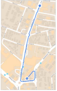
Comparing the routes, we can see that the shape near the end differs. If we zoom in, we can get a better look.
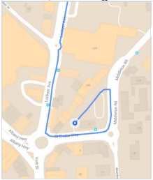
The TryRating route turns left very soon after entering St Emilie Way, whereas the other map’s route continues on for over 200 metres. Does the longer route continue unnecessarily? Or is there a problem with the final part of the TryRating route?
On examining satellite imagery of the location, we can see that there are arrows indicating the direction that traffic must travel.
Checking street imagery at the point where the TryRating route makes its final turn (approx. -35.020796, 117.884066), we can also see there is a No Entry sign. _

If the user were to follow the blue line shown in TryRating and make the final turn, they would be contravening the No Entry sign and driving against the flow of traffic. When multiple MNEs apply in a single location, we should select the most severe error. In this case, we should select Against Traffic (see MNE Driving Routing Guidelines Section 5).
Once we have found an MNE, there is no need to spend time investigating other parts of the route. We can rate this task and move on to the next one.
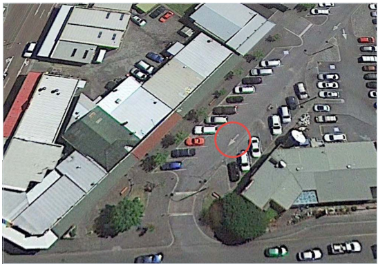
6.Access Restricted
If a route takes a shortcut through the parking area of a parking lot and does not end in an area associated with that parking lot, this is an Access
Restricted MNE.
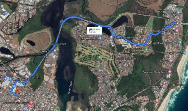
If we zoom in on the final step of the above route, we can see that the destination is a residential address located close to a shopping centre.
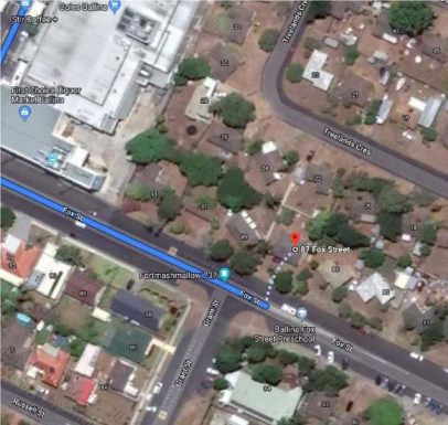
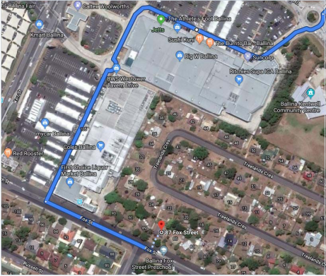
The route travelled through the shopping centre parking lot but ended at an unassociated residential address. Therefore, this route has an Access Restricted MNE.
7.Comments
Whenever you discover an MNE, leave a comment that includes
1)the Step ID of the MNE,
2)a brief explanation of the MNE, and
3)links to any supporting evidence for the discovered MNE (please use a link shortener).
Examples –
Major Road Misalignment
On step N, -1.11111111,-2.22222222, route misses a turn channel that measures 112m from the beginning of the non-lane space to the end. As missed turn channel is >100m long, classed as a Major Road Misalignment.
[link to evidence using link shortener]
On step N, -1.11111111,-2.22222222, route is 61m from current road location. Major Road Misalignment as misalignment is >50m. Confirmed with recent satellite and street imagery. [link to evidence using link shortener]
Physically Impossible
On step N, -1.11111111,-2.22222222, route takes user down a road that does not exist in real world and through a building. Confirmed with recent satellite and street imagery. [link to evidence using link shortener]
On step N, -1.11111111,-2.22222222, road layout has changed and the manoeuvre is no longer possible. Confirmed with recent satellite and street imagery. [link to evidence using link shortener]
On step N, -1.11111111,-2.22222222, route crosses a physical barrier, as seen on street imagery from [month, year]. [link to evidence using link shortener]
Access Restricted
On step N, -1.11111111,-2.22222222, route navigates through a gated community (restricted area). The route does not start or end inside the gated community, so it is an Access Restricted MNE. [link to evidence using link shortener]
Cars Not Allowed
On step N, -1.11111111,-2.22222222, cars cannot drive here as it is a pedestrian-only area. The step list doesn’t tell user to park the car and walk in this area, so this is an MNE. [link to evidence using link shortener]
Against Traffic
On step N, -1.11111111,-2.22222222, route takes user against traffic as confirmed by traffic sign and road markings visible in street imagery from [month, year]. [link to evidence using link shortener]
Illegal U-Turn
On step N, -1.11111111,-2.22222222, route makes U-Turn where a No U-
Turn sign is visible in street imagery. [link to evidence using link shortener]
4
Turn Restriction
On step N, -1.11111111,-2.22222222, route makes a right turn where a No Right Turn sign is visible in street imagery. [link to evidence using link shortener]
Other
On step N, -1.11111111,-2.22222222, [explain in detail why the route is illegal or unsafe]. [link to evidence using link shortener]
8.Links to Road Rules for each State/Territory
Each state/territory has its own version of the road rules. When rating, take note of the state/territory that the task route is located in and ensure that you apply the relevant rules.
ACT Road Rules Handbook http://bit.ly/2OzPvV8
NSW Road Rules http://bit.ly/2IKmQc3
Road Users’ Handbook http://bit.ly/35myeEZ
NT Road Users’ Handbook http://bit.ly/33mdfjx
QLD Road Rules Booklet http://bit.ly/33mevTN
Queensland Road Rules http://bit.ly/329vw3j
SA Road Rules http://bit.ly/35qKQLb
The Driver’s Handbook http://bit.ly/2BgA6RT
TAS Tasmanian Road Rules Booklet http://bit.ly/33kET0q
VIC A-Z of Road Rules http://bit.ly/2IIlK0z
WA Drive Safe – A handbook for Western Australian road users http://bit.ly/35jibHM