This document will give you a quick overview of common mistakes made at routing tasks and how to avoid and identify them.
Some routes direct the driver to perform a U-Turn. In some cases, these U-Turns turn out to be illegal or unsafe. If the step list commands a U-Turn, try to find images of the ground situation. Look out for signs that forbid U-Turns:
 Tips for your rating decision:
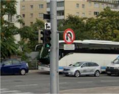
Look for “U-Turn not allowed” signs
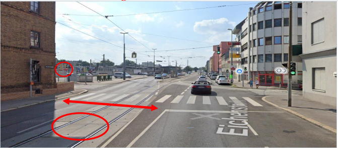
Is there enough space for a U-Turn? Are there tram tracks or street marks?
Is a left turn allowed?
Use common sense and your instinct
A U-Turn not forbidden by signage does not automatically indicate it is legal or safe. Use your common sense or apply traffic laws to decide if a U-Turn is safe & legal.
Example1: The step guide directs a U-Turn at this intersection. There is no signage but there are indications for an illegal/unsafe U-Turn. There are tram tracks, and there is not enough space to finish such a maneuver. In addition, a left turn would be not allowed and result in an Against Traffic MNE.
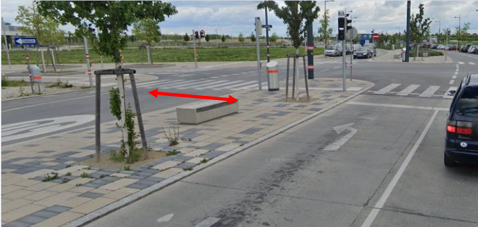
Example 2: At this intersection, a left turn is allowed, but there is not enough space for a safe U-Turn. Consider two or more lanes as considerably safe.
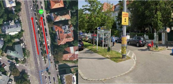
Keep in mind: A route can start with a U-Turn command in the step list, without the blue line following the maneuver. This qualifies for an MNE.
Spotting Against Traffic MNEs can sometimes be difficult. In this case, the route starts with a suspicious step. Since there is street view available, we use it to verify a possible MNE. At street image level, we can see Against Traffic signs so the street view image confirms the illegal move – the correct rating is MNE Against Traffic.

In the next example, the route starts in a secondary lane (Nebenfahrbahn) and directs the driver against the traffic flow. Since the available street image does not show a one-way sign, we would not expect an MNE. However, this is a secondary lane, which is naturally a one-way street. Therefore, an MNE Against Traffic is the correct rating. The absence of street signs does not automatically indicate legal maneuvers.
Keep in mind: If you are unsure whether a scenario qualifies for an MNE rating, always check the guideline for similar examples, trust your instinct, and apply common sense.
If a route starts or ends in an unusual area, check if cars are allowed in such areas (e.g. pedestrian zones or walkways) like in the pictures below. Look for street signs, curbs, or other indications. Check the step list, especially at the end of a route, for “prepare to park your car” instructions. This will avoid wrong conclusions.
Furthermore, checking the beginning or end of any route for barriers or blockages is essential for detecting possible issues.
In general, take your time with the “inch-by-inch” route reviewing method. You may miss MNEs if you are too fast. If you find any suspicious route behaviour, dig deeper as well, and use street view and satellite imagery to identify possible MNEs (or non- MNEs).
When reviewing a route, start checking the beginning and the end. This can save a lot of time in case there is an MNE at the end of the route.
If you immediately spot anything that looks suspicious or strange along the course of a route while zoomed out, check there first before starting to evaluate the route from the beginning.
Use the option to view historical imagery on Google Earth. This can help in determining whether the task map shows an outdated satellite view.
Use different maps to compare the data. This is even more important if information is not always visible on the map, e.g. signs are hidden by a car.
When street imagery is not available, it can be helpful to check if there is imagery for POIs/businesses in the immediate vicinity. Sometimes, such images include relevant sections of the route you are evaluating.
If you find any MNE, please copy the corresponding step & coordinates into the comment field and describe the issue. Also share street or satellite images (please use link shorteners).