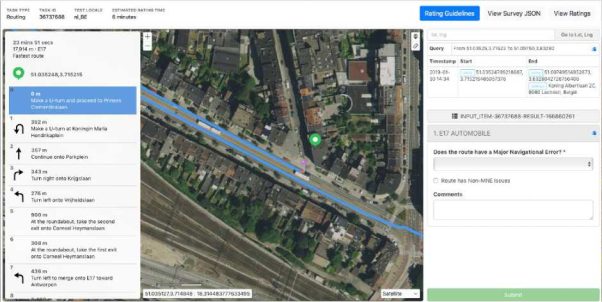
Tip: Sometimes you can easily spot a problem area in a task route by requesting the same route in a different map application and quickly comparing the shapes of the routes. Investigate any obvious differences to determine whether they are caused by a Major Navigational Error in the TryRating route. If you find an MNE, you do not need to continue checking the remainder of the route.
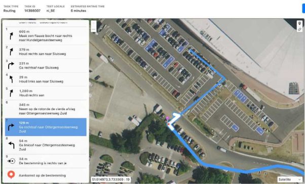
Approach rating efficiently by evaluating the route and identifying the high-risk areas. Start by evaluating these for an MNE. What are high risk areas?
Obviously, you should not rule out anything, but spending time on high-risk areas, instead of tracking the route along a major road, especially rural ones, where perhaps two other map applications agree with the routing, is simply more effective way of evaluating the route.
In Belgium, U-Turns are legal unless explicitly stated that they are not. Situations where it is illegal include: when crossing a continuous white line and when a sign forbids a U-Turn.
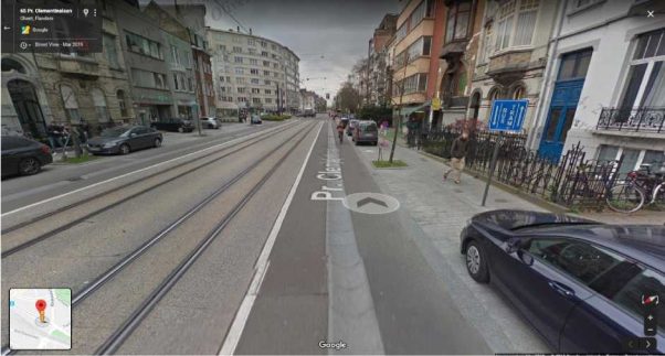
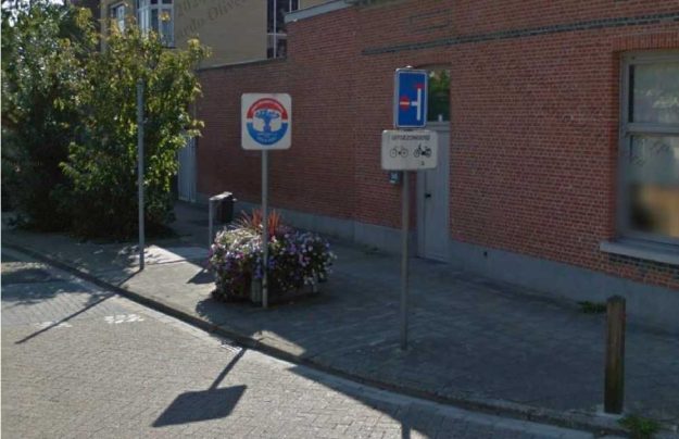
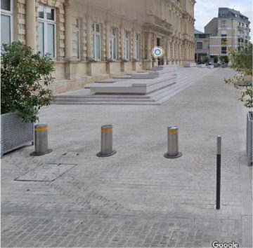
Some routes may begin with a U-Turn, as seen in the screenshot below. These cases should also be validated for whether or not a U-Turn is legal at that spot. In these cases, we should assume a driver was navigating from the opposite direction and will be making a U-Turn approximately at the start of the route.
As visible in Street Imagery, U-turn is not permitted here as it is prohibited by continuous white line dividing designated lanes for buses and trams.
A route has an Against Traffic error when it navigates the wrong way down a street. Against Traffic should only be used in cases where a user following the blue line would think they are being instructed to drive the wrong way down a road. This error is usually hard to spot using only the satellite map layer. It is necessary to use street imagery and look for any street signs indicating the driving direction
Against traffic errors can be fairly common in Belgium, especially in dense areas with narrow roads. Pay attention to the width of the road and signs. The direction of parked cars can also indicate if there is a one-way road.
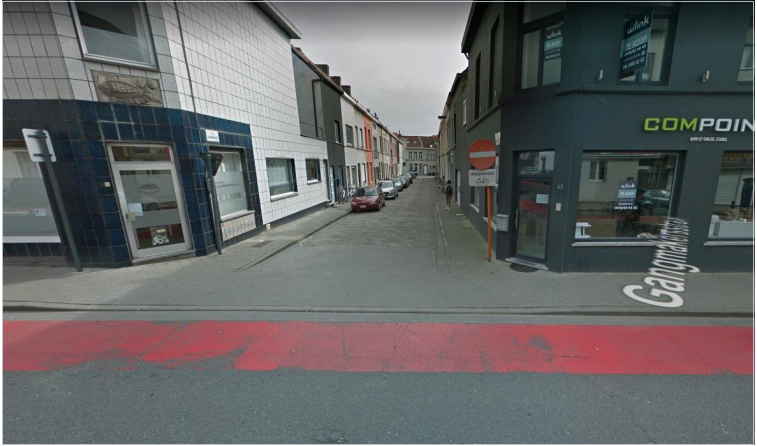
Relatively common scenario of ‘Against Traffic MNE’ could be found on routes that make a turn onto a one-way road. In this example the route instructs the user to make a left turn onto Gangmakersstraat (51.03596, 3.72628)
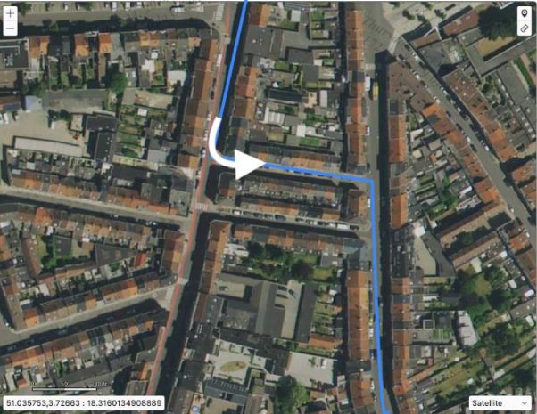
As we can see the cars are parked facing the same direction and more importantly if we look at this street using street imagery, we can see that this is indeed a one-way road.
When the route illegally turns onto a one-way street, always select Against Traffic rather than Turn Restriction. See section 5.1 of the guidelines.
Another case of Against traffic error happens when the user is navigated to drive through a parking lot in a direction which is not allowed. Driving direction is usually indicated by arrows on the road surface or by street signs. In the following example the user is navigated to enter the parking as depicted below.
When you look closely at the satellite map layer image below you can see that there are white arrows indicating traffic direction on the ground surface of the parking lot. The route navigates user to go in the opposite direction, which is against traffic.
A route may be impossible to follow if it uses roads that do not exist in real life, or if it requires user to pass through permanent physical barriers. Sometimes there is a step in a route which is impossible to perform in real world. Street Imagery is generally very helpful to review required manoeuvres.
In this example the blue line instructs the user to turn right onto the Hippolyte Meeùsstraat. If we look closer, we can see some shadows on the road, which indicates there is potentially an obstruction on the road.
If we look at this street in street view, we can see that there are several poles in the middle of the street that will not allow cars to pass. It is physically impossible.
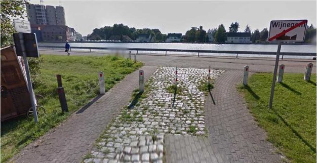
In cases like this, there will often be a sign that indicates that there will be a dead end, as seen here at the start of this road.
A Turn Restriction error should be indicated when the route has asked you to make a turn that is physically possible but disallowed by signage or other restrictions. A user can be instructed to perform a turn where it is not allowed. In this task the user is instructed to make a right turn (50.820722, 4.370405) and to drive onto the parallel road.
When we look at this intersection using street imagery, we can see that drivers are not allowed to make a left or right turn here. Turning right here would be illegal.

Another common error that appears in the routing tasks is a Cars Not Allowed MNE. It occurs when the route leads the user through a road or path that can only be used by buses, bicycles, motorcycles or pedestrians. You should always look for street signs using street imagery. Pedestrian only areas can be common in Belgium. These are especially common around city centres.
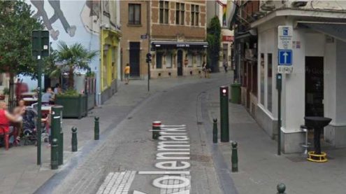
In this example, the user is instructed to turn left and follow Kiekenmarktstraat [50.846442, 4.349154].
This looks like a regular road from above, but if we look closer using street imagery, we can see that this is a pedestrian only area.
Pedestrian Only:
Like bicycle lanes, pedestrian only areas are also common. These are especially common around city centers. These pedestrian only areas might also look like roads from above.
Here the route follows the Hagenstraat and then instructs the driver to enter the Varkensmarkt (51.988555, 6.567562).
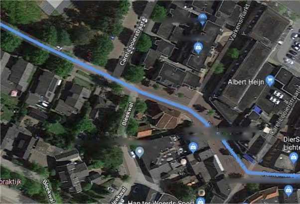
This looks like it could be a road, but if we look at this area in street view we can see that this is a pedestrian only area where cars aren’t allowed.
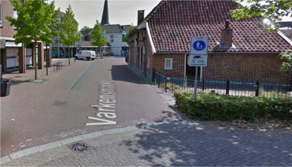
Pedestrian only areas are not considered Access Restricted zone so even if the blue lines begins or ends in the pedestrian only areas, it would still be considered MNE.
An Access Restriction MNE occurs when:
Routes whose blue route line begins or ends in a restricted access area or on a private road are assumed to have access to those roads and areas.
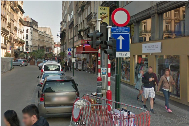
Belgium has private roads and roads that are restricted to people who live nearby. The route should not use these roads unless the route starts or ends there. In this example the route fully passes through Kiekenmarktstraat [50.849362, 4.349456].
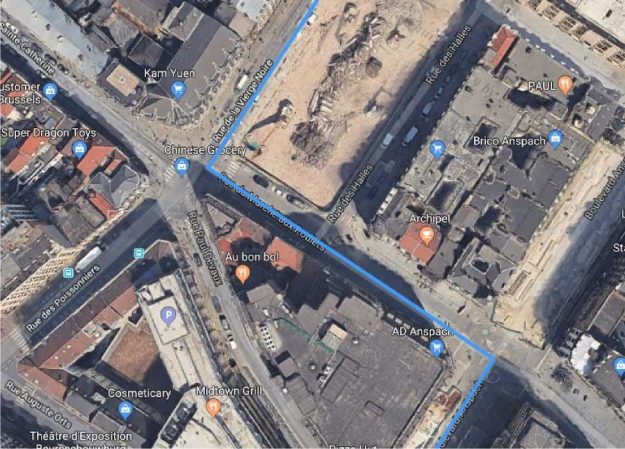
If we look at available street imagery, we can see that this road is restricted to people who live here and should not be used by regular drivers.
Common mistakes 1:
Majority of analysts rated this task as an MNE
Step 12: Lat/lng 49.257761,4.031626 – blue route ends in a restricted area (roadblocks) so NOT an MNE (GL 4.3)
Common Mistakes 2:
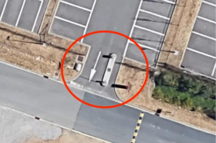
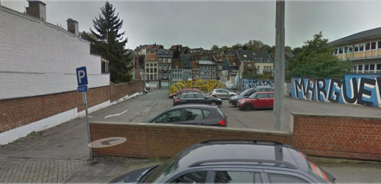
If the road is crossing through a parking lot for a shortcut (and if it is not the end of the route), this should be considered as an MNE.
Roads are always changing, and maps aren’t always up to date. The blue line can often appear to be misaligned because satellite images are dated. It’s important to do research to find out the actual layout of the road.
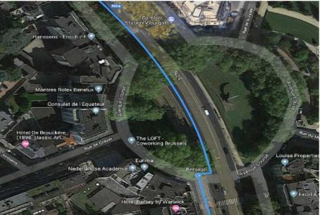
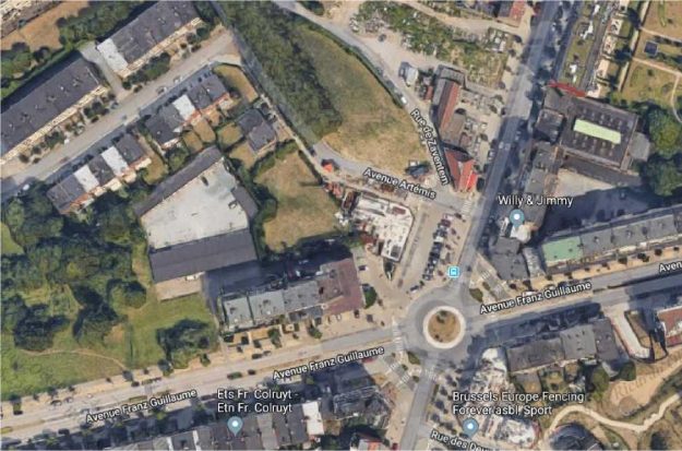
In this task, the route instructs the user to take the fifth exit on this roundabout here (50.862230, 4.415897).

If we look at more recent street imagery we can see that this roundabout no longer has this layout. It’s no longer possible to drive here. For this route we should therefore select Physically Impossible.
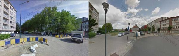
Street imagery often lets us review old images. That way we can also see how this roundabout has changed over the years. This entire section of the road no longer exists.
Some routes include instructions for the user to park their car. This usually occurs when the route continues in areas where cars are not allowed, or parts where cars can’t physically go. The route should not be considered to have a Cars not Allowed MNE after this step.
Do not consider if a user is legally allowed to park their car at the step where “Prepare to park your car” is indicated. This guidance is not intended to indicate a specific parking spot but rather that the user will need to park and proceed on foot from this point on.

When route has a Major Issue, analyst is required to indicate which step the MNE was found. Examples of a good comments:
MNE | Comment |
Major Road Misalignment | On step N, -1.11111111,-2.22222222, route is missing a roundabout larger than 50m. It is considered a major misalignment and is rated as MNE. [link to resource]. On On step N, -1.11111111,-2.22222222, route misses a slip lane/turn channel that measures more than 100m from its start (and/or blue line crosses it more than 50m from its starts). It is considered a major misalignment and is rated as MNE. [link to resource]. On step N, -1.11111111,-2.22222222, route is more than 50 meters misaligned with real world. Standard and Satellite views and other maps providers were checked and confirm the MNE. [link to resource]. |
Physically impossible | On step N, -1.11111111,-2.22222222, route takes user to a road that does not exist in real world. It is physically impossible. [link to resource]. On step N, -1.11111111,-2.22222222, road map has been updated and the maneuver is not possible anymore. Standard and Satellite views and other maps providers were checked and confirm the MNE. [link to resource]. On step N, -1.11111111,-2.22222222, route crosses a physical barrier, as seen on street imagery from December 2020. It is physically impossible. [link to resource]. |
Access restricted | On step N, -1.11111111,-2.22222222, user cannot access it, as it is a restricted area. The route is does not start there and it is not user’s destination, so it is marked as a MNE. [link to resource]. |
Cars not allowed | On step N, -1.11111111,-2.22222222, cars cannot access it, as it is a pedestrian area. The route is does not tells user to park the car and walk in this area, so it is marked as a MNE. [link to resource]. |
Against traffic | On step N, -1.11111111,-2.22222222, route takes user against traffic as seen on street imagery from December 2020, and traffic signs. [link to resource]. |
Illegal U-turn | On step N, -1.11111111,-2.22222222, route takes user to make an illegal U- turn. [Explain why U-turn is illegal]. [link to resource]. |
Turn restriction | On step N, -1.11111111,-2.22222222, route takes user to make a right/left turn that is not allowed as seen on street imagery from December 2020 and traffic signs. [link to resource]. On step N, -1.11111111,-2.22222222, route takes user to make a right/left turn that is not allowed as seen on street imagery from December 2020, continuous yellow line indicates the turn is illegal. [link to resource]. |
Other | On step N, -1.11111111,-2.22222222, [explain with details what is wrong with the route]. [link to resource]. |