Introduction: This document provides key information to help analysts from non-US markets rate US Routing tasks correctly.
Tip #1 – Driving Side: Drivers in the US drive on the right side of the road.
Tip #2 – Driving Laws: Driving laws will vary slightly in each state, and even in some cities. The most common laws that impact rating and that will vary are U- turn laws.
The best way to research U-Turn laws is by doing a search for “Driving Manual in (state or city the route is in).” You want to make sure you are using a reliable resource for these laws. Local government websites are the best resource. Generally, if the website ends in (.gov), it is a good indication that it is a reliable website. Once you find the online manual, use the “Find” feature (Control F in Windows based systems and Command F in Apple based systems) and search for “U-turn.” You may also want to try “uturn” and “u turn” as search options if nothing is found.
Tip #3 – Road Signs & Pavement Markings:
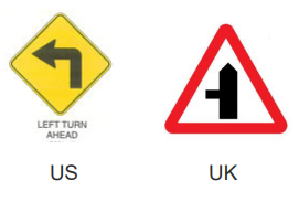
Road Signs: In the United States the road signs follow federally regulated standards laid out in the “Manual on Uniform Traffic Control Devices (MUTCD). These are not the same standards as other countries and the signage appearance in the US is quite different. For example, a yellow diamond shape is used for warning signs in America, whereas the same is represented in Europe by triangular signs with a red border.
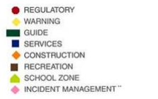
According to the MUTCD “The color of roadway signs is an important indicator of the information they contain. The use of red on signs is limited to stop, yield, and prohibition signs. A white background indicates a regulatory sign; yellow conveys a general warning message; green shows permitted traffic movements or directional guidance; fluorescent yellow/green indicates pedestrian crossings and school zones; orange is used for warning and guidance in roadway work zones; coral is used for incident management signs; blue indicates road user services, tourist information, and evacuation routes; and brown is for guidance to sites of public recreation or cultural interest.”
“Sign shape can also alert roadway users to the type of information displayed on a sign. Traffic regulations are conveyed in signs that are rectangular with the longer direction vertical or square. Additional regulatory signs are octagons for stop and inverted triangles for yield. Diamond-shaped signs signify warnings. Rectangular signs with the longer direction horizontal provide guidance information. Pentagons indicate school zones. A circular sign warns of a railroad crossing.”
Illustration of how sign colors and shapes are used:
Link with Images of Road Signs:
https://mutcd.fhwa.dot.gov/services/publications/fhwaop02084/index.htm
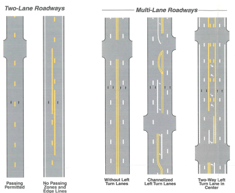
Pavement Markings: A pavement marking is part of a communication system for road users. In addition to road signs and signals, pavement markings communicate to drivers where to position their vehicles, warn about upcoming conditions, and indicate where passing is allowed.
Link with Images of Pavement Markings:
https://mutcd.fhwa.dot.gov/services/publications/fhwaop02090/index.htm
Additional Research Links to better understand signs in the United States https://en.wikipedia.org/wiki/Road_signs_in_the_United_States
Tip #4 – Painted Lines: Solid white lines define lanes of traffic going in the same direction, or they show you the location of the shoulder of the road. Broken white lines are used to show the center line between lanes. Yellow lines show you where traffic is going in different directions.
Yellow Painted Lines:
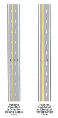
Single Yellow Line: A yellow line (solid or dashed) indicates that crossing this line will position a driver in a lane where opposing traffic is coming at the driver. In the US, single solid yellow lines are prohibited on two-way undivided roadways. A single broken yellow line separates opposing traffic and means that passing with care is allowed for traffic in either direction. The MUTCD authorizes use of a single solid yellow line in only two contexts: on divided highways to mark the left side of the lane closest to the median (for traffic in both directions), and to mark the left side of the leftmost lane on one-way ramps.
Double Yellow Line: A double yellow line is a painted marking dividing two lanes of a road. It consists of two parallel, solid yellow lines, and its presence indicates a two-direction no-passing restriction/no passing zone, where traffic in both directions is prohibited from crossing the line to pass other traffic. There are several major exceptions to the rule against crossing a double yellow line including turning left into a side street or driveway and for temporary traffic flow changes due to road work.
In some areas, the double yellow line may have segments where one of the lines becomes dashed. This kind of marking designates a one- direction no-passing zone. Drivers traveling on the side closest to the dashed line may pass with care when safe, while drivers traveling on the side closest to the line that remains solid are prohibited from passing.
Examples of how yellow lines are used in the US:
Tip #5 – Outdated Street Views: For such cases, we still suggest using it to get an idea of the road geometry but also alternate it by using the satellite layer to review the blue line. There might be times when you will be able to spot errors on this layer, but please try your best on finding alternative sources to reach out to a conclusion.
Tip #6 – Do we always have to research the state driving laws of each task we evaluate? Our general recommendation is to always use the proper regulation for each state, but especially when you find any odd maneuver or road sign where you are having any difficulty determining if it is an MNE.
Tip #7 – What are the rules for U-turns at intersections? The legality of U- turns at intersections will vary depending on the state the road is located in. In
addition, to researching local laws, please also note signage that indicates if U turns are legal.
Tip #8 – What happens when I find a construction site while reviewing the blue line? In those cases, we suggest doing some additional research of the road status.sThis information can be found within news articles, government .,
sites and the Department of Transportation and Infrastructure of each state.
Tip #9 – How can I determine if the blue line is going against the traffic as there are not road signs in the pavement, what should I do? Please explore the area with a street view to observe transit flow of the vehicles and
the position of the available road signs within the corners of the streets or