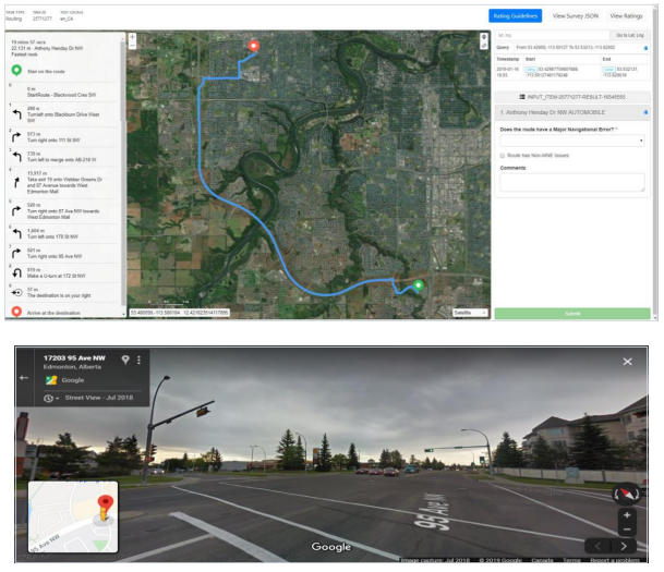
Analysts need to verify every turn on a route to ensure that the maneuver can be completed. Check for signage as well as arrows painted on the road.
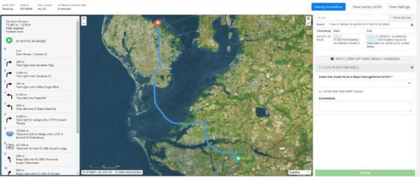
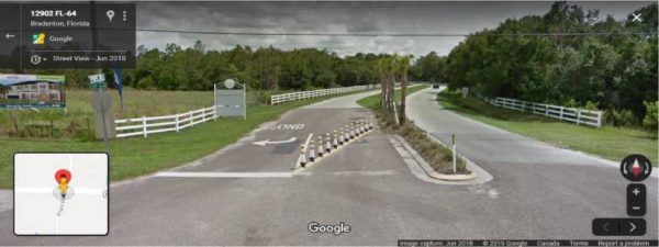
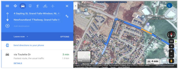
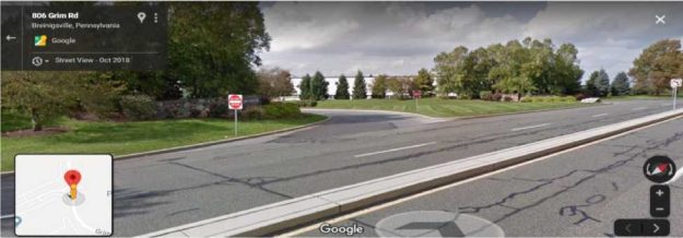
In Step 5 of this example, the user is directed to take a left turn from Pope Rd. onto E State Road 64, but current street imagery confirms that a user would not be able to turn left here due to a physical barrier.
U-Turns are not always legal in Canada. When verifying if a U-turn is legal, check:
prohibited at any intersection.
Example of Illegal U-turn (Step 10) in Quebec where sign prohibits U-turn.
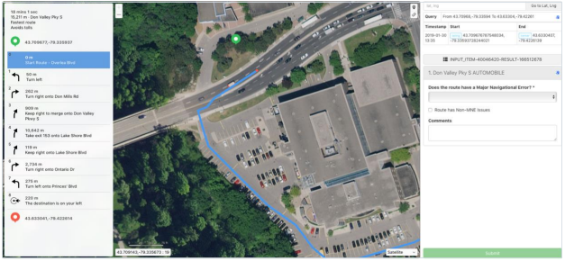
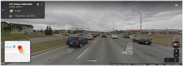
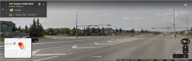
In this example, in Step 8, user is directed to make a U-Turn in Alberta at an intersection with traffic lights, where U-turns are prohibited.
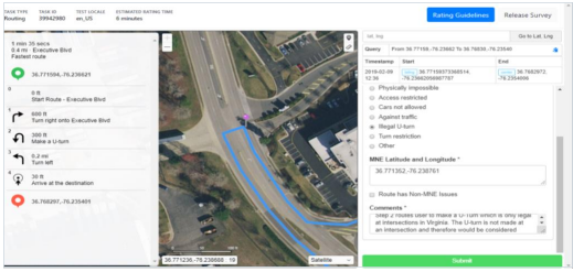
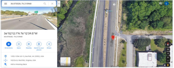
In this example of an Illegal U-turn in Virginia, in Step 2, the user is directed to make a U-turn that is not at an intersection. U-turns are only permitted at an intersection in Virginia. (source: https://law.lis.virginia.gov/vacode/46.2-845/)
Road layouts often change and sometimes the satellite imagery is not up to date. Further research is needed to determine the most current and accurate ground-truth by utilizing satellite/street view imagery in map providers or other official sources.
In this example, the blue deviates significantly from the road according to our satellite imagery.
However, after further research, it is confirmed that our route is accurate to the current ground-truth while our satellite imagery is outdated.
In this example, it appears the blue line is misaligned with the road in satellite view. However, we can investigate further by dropping a pin on the blue line and copying the coordinates to a map provider to determine the most current ground-truth road layout.

Below, we can see that our blue line is routed accurately according to the most current satellite imagery.
Routes can direct the user to a road that does not exist. Analysts need to investigate by utilizing street imagery and satellite views in different map providers to determine if the road exists.
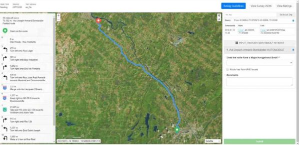
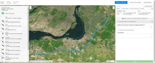
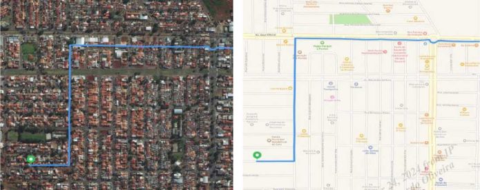
In Step 9 of this example, the user is directed to turn left onto Rue De Monaco from Rue Legardeur, which is Physically Impossible since these roads do not connect.
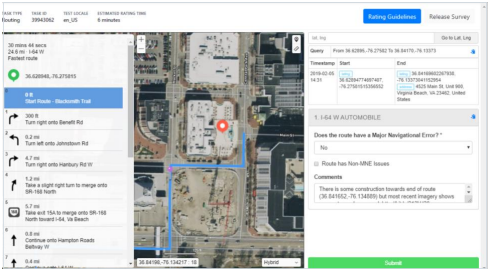
It is common to come across areas on routes that are under construction. Major road construction can leave roads and highway areas inaccessible. Analysts need to check alternate satellite/street imagery in different map providers to determine the most up-to-date view of the road.
In this example, there is construction near the end of the route. Further investigation is needed to verify if the roads near the construction are accessible.
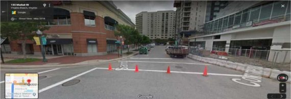
Street Imagery from May 2018 shows the road is blocked off.
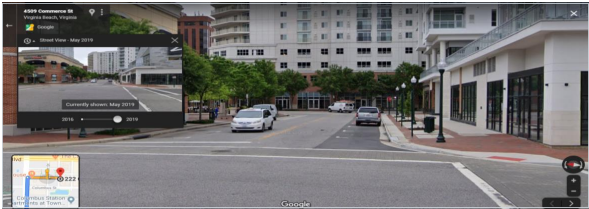
However, the most current street imagery, in May 2019, shows the road is accessible and, therefore, it is not considered an MNE to route onto this road.
In Step 4 of this example, the user is asked to take a left the wrong way down a street and over a concrete barrier which can be confirmed using street imagery.
4 Access Restricted
Analysts need to check current ground-truth using street imagery to verify whether a route is directing user through a restricted access area or a road with a time of day restriction.
In this route for example, the user is clearly routed through a parking lot as seen in the Tryrating satellite
5 Issues with Satellite View – NOT an MNE
Sometimes Satellite and Standard layers are not aligned, and it might make it tricky to rate routes in those cases. Analyst is expected to always rate the route against real world, but needs to pay extra attention when odd misalignments, in some cases the whole route, is noticed. In those cases, use the Hybrid view and a comparison side by side of Standard and Satellite and other maps providers will make it clear if Satellite View is misaligned and the “fake” misalignment is not rated as an MNE.
When we look at the satellite view, it looks like a misalignment over 50 meters is happening, but when we check on Hybrid and Standard views, we can see that it is an issue with the layers, not with the route itself.
6 Against Traffic
Analysts need to verify that each street along the route is navigating the correct direction of traffic. Thedirection of traffic can be determined by using satellite and street view imagery in different map providers, paying close attention to painted arrows and markings on the road as well as signage.
In Step 3 of this example, user is directed to turn left where the blue line misses the turn channel of greater than 100 meters in distance.
Older street imagery shows that it was previously only a left turn lane.
Current imagery confirms that it has been updated into a turn channel with a painted divider.
When the route has a Major Issue, analysts are required to indicate which step the MNE was found.
Examples of a good comments:
MNE | Comment |
Major Road Misalignment | On step N, -1.11111111, -2.22222222, route is missing a roundabout larger than 50m. It is considered a major misalignment and is rated as MNE. [link to resource]. On step N, -1.11111111, -2.22222222, route misses a slip lane/turn channel that measures more than 100m from its start (and/or blue line crosses it more than 50m from its starts). It is considered a major misalignment and is rated as MNE. [link to resource]. |
| On step N, -1.11111111, -2.22222222, route is more than 50 meters misaligned with real world. Standard and Satellite views and other maps providers were checked and confirm the MNE. [link to resource]. |
Physically impossible | On step N, -1.11111111, -2.22222222, route takes user to a road that does not exist .X in real world. It is physically impossible. [link to resource]. On step N, -1.11111111, -2.22222222, road map has been updated and the maneuver is not possible anymore. Standard and Satellite views and other maps providers were checked and confirm the MNE. [link to resource]. On step N, -1.11111111, -2.22222222, route crosses a physical barrier, as seen on street imagery from December 2020. It is physically impossible. [link to resource]. |
Access restricted | On step N, -1.11111111, -2.22222222, user cannot access it, as it is a restricted area. The route is does not start there and it is not user’s destination, so it is marked as an MNE. [link to resource]. |
Cars not allowed | On step N, -1.11111111, -2.22222222, cars cannot access it, as it is a pedestrian area. The route is does not tells user to park the car and walk in this area, so it is marked as an MNE. [link to resource]. |
Against traffic | On step N, -1.11111111, -2.22222222, route takes user against traffic as seen on street imagery from December 2020, and traffic signs. [link to resource]. |
Illegal U-turn | On step N, -1.11111111, -2.22222222, route takes user to make an illegal U-turn. [Explain why U-turn is illegal]. [link to resource]. |
Turn restriction | On step N, -1.11111111, -2.22222222, route takes user to make a right/left turn that is not allowed as seen on street imagery from December 2020 and traffic signs. [link to resource]. On step N, -1.11111111, -2.22222222, route takes user to make a right/left turn that is not allowed as seen on street imagery from December 2020, continuous yellow line indicates the turn is illegal. [link to resource]. |
Other | On step N, -1.11111111, -2.22222222, [explain with details what is wrong with the route]. [link to resource]. |