Tip: Sometimes you can easily spot a problem area in a task route by requesting the same route in a different map application and quickly comparing the shapes of the routes. Investigate any obvious differences to determine whether they are caused by a Major Navigational Error in the TryRating route. If you find an MNE, you do not need to continue checking the remainder of the route.
Approach rating efficiently by evaluating the route and identifying the high-risk areas. Start by evaluating these for an MNE. What are high risk areas?
^ • Junctions and road signs
0^
Obviously, you should not rule out anything but spending time on high-risk
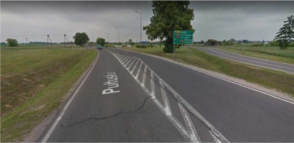
areas, instead of tracking the route along a major road, especially rural ones, where perhaps two other map applications agree with the routing, is simply more effective way of evaluating the route.
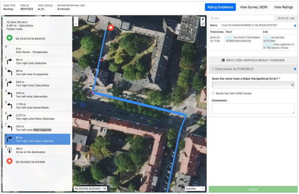
A route may be impossible to follow if it uses roads that do not exist in real life, or if it requires user to pass through permanent physical barriers. Sometimes there is a step in the route which is impossible to perform in real world. Street Imagery is generally very helpful to review required manoeuvres. In the following example the user is instructed to turn right onto Aleja Legionów.
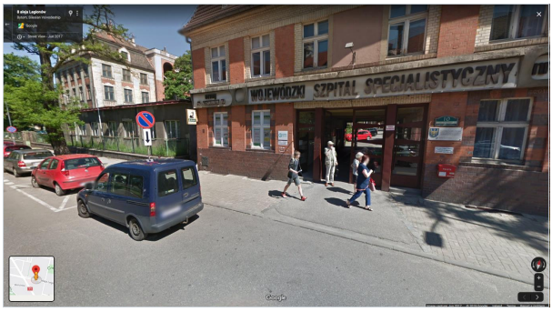
In a satellite imagery it seems that a user is navigated to drive through a building. When we verify using street imagery, it confirms that this turn is indeed physically impossible to perform.
A route has an Against Traffic error when it navigates the wrong way down a street. Against Traffic should only be used in cases where a user following the blue line would think they are being instructed to drive the wrong way down a road. This error is usually hard to spot using only the satellite map layer. It is necessary to use street imagery and look for any street signs indicating the driving direction. In the example below the route navigates user to turn left onto Jasia i Małgosi

This is in fact against traffic, but it´s impossible to tell from the satellite layer only. When you look at the following street imagery, you can see that there is a “against traffic” sign visible
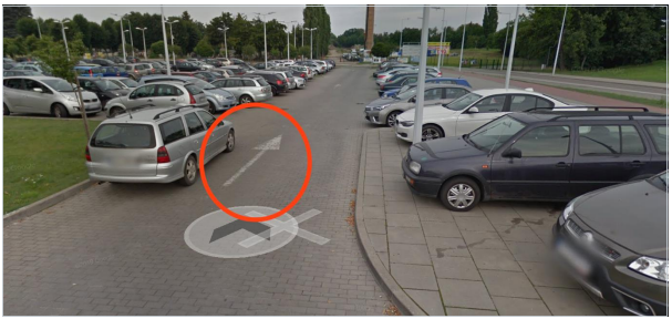
Another case of Against traffic error happens when the user is navigated to drive through a parking lot in a direction which is not allowed. Through some parking lots you can drive in either direction, but in other parking lots there is
. . . . . , . .
only one allowed driving direction and it´s usually indicated by arrows on the road surface or by street signs. In the following example the user is navigated to exit the parking lot against traffic as depicted below.
When you look at both the satellite map layer image (above) and the street imagery (below), you can see that there are white arrows indicating the direction on the ground surface of the parking lot, and the route is actually telling the user to go in the opposite direction, which is against traffic
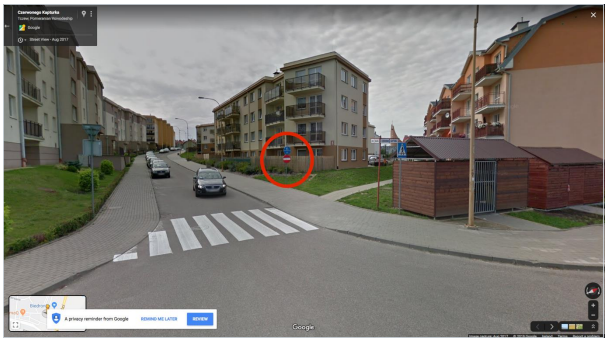
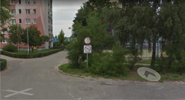
Some routes may begin with a U-Turn, as seen in the screenshot below. These cases should also be validated for whether or not a U-Turn is legal at that spot. In these cases, we should assume a driver was navigating from the opposite direction and will be making a U-Turn approximately at the start of the route. See GL 4.6 for more details.

As visible in Satellite View and also in Street Imagery, U-turn is not permitted as indicated by P-21 road surface sign.
5. Cars Not Allowed
Another common error that appears in the routing tasks is a Cars not allowed
MNE. It occurs when the route leads the user through a road or path that can only be used by buses, bicycles, motorcycles or pedestrians. You should always look for street signs using street imagery. In the following example there is a sign restricting entry of vehicles clearly visible in Street Imagery.
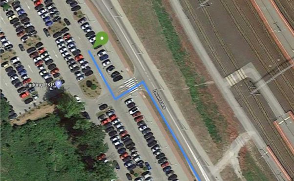
There are cases when the route requires the user to drive through a parking lot, but the route neither starts, nor ends inside the parking lot. Such a case would be classified as Access restricted MNE. In the example below the user is directed to turn left and drive through a parking area, exit it on the other side and continue driving.
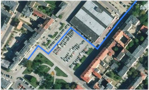
In the following street imagery, you can see the points where the route enters and exits the parking lot.

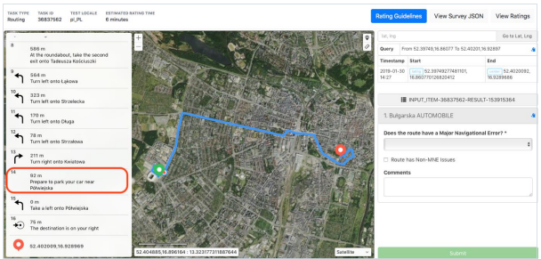
Do not consider if a user is legally allowed to park their car at the step where “Prepare to park your car” is indicated. This guidance is not intended
to indicate a specific parking spot but rather that the user will need to park and proceed on foot from this point on.
When route has a Major Issue, analyst is required to indicate which step the MNE was found. Examples of good comments:
MNE | Comment |
Major Road Misalignment | On step N, -1.11111111,-2.22222222, route is missing a roundabout larger than 50m. It is considered a major misalignment and is rated as MNE. [link to resource]. On On step N, -1.11111111,-2.22222222, route misses a slip lane/turn channel that measures more than 100m from its start (and/or blue line crosses it more than 50m from its starts). It is considered a major misalignment and is rated as MNE. [link to resource]. On step N, -1.11111111,-2.22222222, route is more than 50 meters misaligned with real world. Standard and Satellite views and other maps providers were checked and confirm |
Physically impossible | On step N, -1.11111111,-2.22222222, route takes user to a road that does not exist in real world. It is physically impossible. [link to resource]. On step N, -1.11111111,-2.22222222, road map has been updated and the maneuver is not possible anymore. Standard and Satellite views and other maps providers were checked and confirm the MNE. [link to resource]. On step N, -1.11111111,-2.22222222, route crosses a physical barrier, as seen on street imagery from December 2020. It is physically impossible. [link to resource]. |
Access restricted | On step N, -1.11111111,-2.22222222, user cannot access it, as it is a restricted area. The route is does not start there and it is not user’s destination, so it is marked as a MNE. [link to resource]. |
Cars not allowed | On step N, -1.11111111,-2.22222222, cars cannot access it, as it is a pedestrian area. The route is does not tells user to park the car and walk in this area, so it is marked as a MNE. [link to resource]. |
Against traffic | On step N, -1.11111111,-2.22222222, route takes user against traffic as seen on street imagery from December 2020, and traffic signs. [link to resource]. |
Illegal U-turn | On step N, -1.11111111,-2.22222222, route takes user to make an illegal U- turn. [Explain why U-turn is illegal]. [link to resource]. |
Turn restriction | On step N, -1.11111111,-2.22222222, route takes user to make a right/left turn that is not allowed as seen on street imagery from December 2020 and traffic signs. [link to resource]. On step N, -1.11111111,-2.22222222, route takes user to make a right/left turn that is not allowed as seen on street imagery from December 2020, continuous yellow line indicates the turn is illegal. [link to resource]. |
Other | On step N, -1.11111111,-2.22222222, [explain with details what is wrong with the route]. [link to resource]. |