Below are the most common issues in Singapore routing tasks:
A Physically Impossible MNE is indicated when the route instructs the user to use roads that do not exist in real life; or requires him/her to perform impossible driving manoeuvres, such as driving over kerbs or passing through road railings/
physical barriers (see Section 4 of Routing Guidelines).
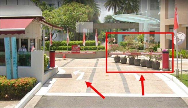
In the example below, on Step 10 – the route directs the user to turn right into the car park of a private condo complex at Flora Drive [1.359338,103.964855]. And based on the blue route line, he/she is to take another right turn to arrive at the destination.
We can determine that this task has no Access Restricted issue. As the route ends within the gated property, we should assume that the route requester is a resident or an invited guest (Routing Guidelines 4.3).
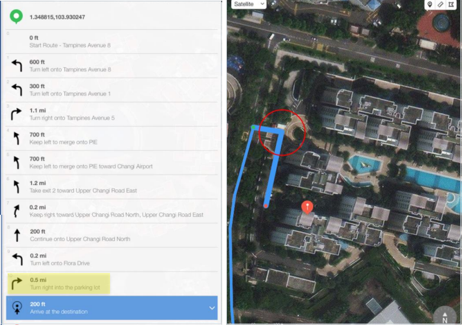
However, on street imagery, there is a row of flowerpots blocking the road near the entrance of the property, which makes it impossible for the user to turn right.
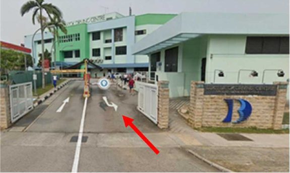
Thus, this route should be rated MNE Physically Impossible; or MNE Turn Restriction, as the painted arrow on the road indicates a Left Turn only. It is not considered a minor misalignment, as the roundabout is clearly seen on the basemap and satellite images.
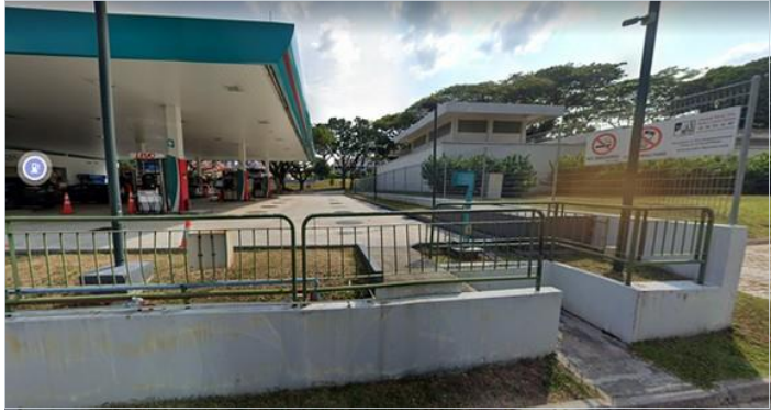
In another example below, on Step 3 – at [1.379162,103.836133], the user is directed to take a left from the SPC petrol station into the service road and towards the car park
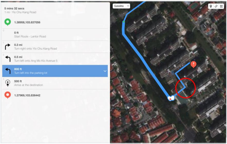
From the street imagery, we can see that it is physically impossible to do so, as there are railings at the back of the petrol station obstructing the path to the car park.
A Turn Restriction MNE is indicated when the route directs the user to make a turn that is physically possible but is disallowed by signage or other restrictions (See Routing Guidelines 4.7).
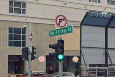
Below is an example of a turn restriction due to the painted marking on the road. In this scenario, a right turn is not allowed.
Another example of the turn restriction on the image below.
It should be noted that if the route illegally turns onto a one-way road going the wrong direction, then you should select Against Traffic MNE rather than Turn
Restriction MNE (see Routing Guidelines 5.1).
There is a turn restriction applied on some roads at certain time of the day.
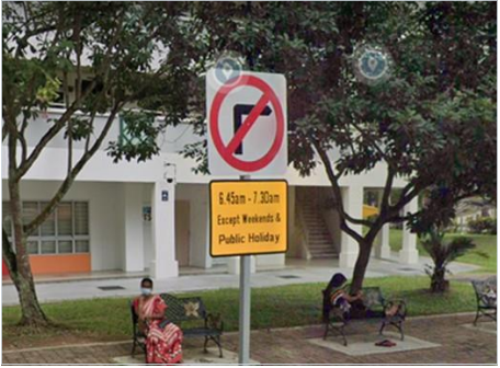
You should always check on the route date and time stamp to determine whether the restricted hours were in operation when the query was made. You should then estimate the time taken to arrive at the step and rate accordingly.
An Access Restricted MNE is indicated if the route passes through a restricted access area or uses a road that an average driver would not be allowed to use (Routing Guidelines 4.3).
In the following example, on Step 1 – at Canberra Drive [1.439079,103.829701], the route directs the user to turn right onto YISHUN SAPPHIRE, then exit the property before continuing with the journey.
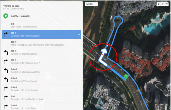
We can determine that this right turn is not permitted, as it passes through YISHUN SAPPHIRE, a gated property which is not the intended destination. Hence this route has Access Restricted MNE.
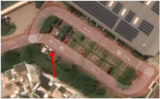
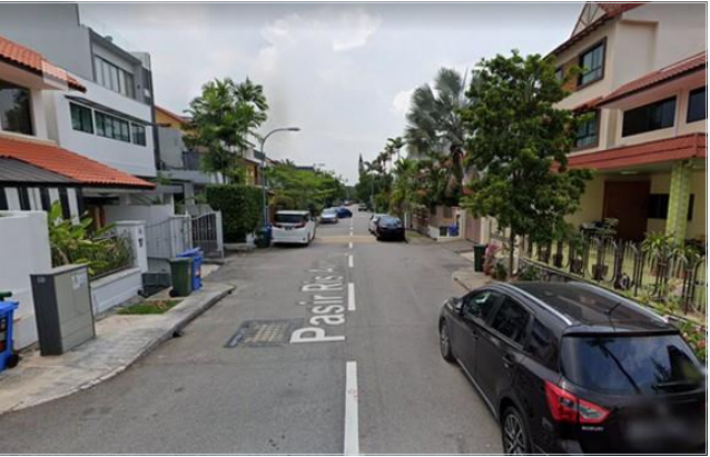
Against Traffic MNE is indicated when the route navigates the wrong way down the street (Routing Guidelines 4.5).
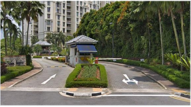
In the example below, the route starts on the service road at [1.412315,103.897951].
It directs the user to turn left onto Sumang Walk, before continuing with the journey.
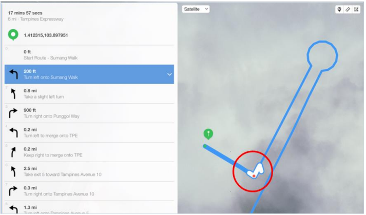
If we refer to the street imagery, we can see that the junction at this point is only for vehicle entrance, based on the painted arrow. Hence, we should indicate the route as having MNE Against Traffic issue.
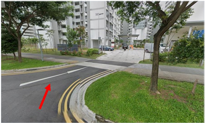
In another example below, on Step 8 – after turning left into the car park at [1.324671,103.806629], assessing from the blue route line, the user is to take a right to arrive at the destination.
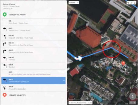
Street imagery is not available for this location, so we should refer to the satellite view (https://goo.gl/maps/ENvTF7wjeWf8VxEu5). Here we can determine from the road marking here that it is a one-way road, hence this route goes against traffic.
Whenever there is a step in a route that indicates a U-Turn, you should always verify it via street-level imagery. This is because under the Road Traffic Rules in Singapore, “No driver or rider of any vehicle shall make a U-turn at any road intersection, road junction or opening in a road divider unless he is permitted to do so by a road sign.” (https://bit.ly/3ooyXRQ)
Without this sign, the U-turn manoeuvre is illegal.
An example is a routing instruction for the user to turn left onto Tampines North Drive 1. The user is then directed to make a U-turn at [1.37124,103.93282] before turning right onto Tampines Link.
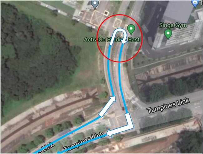
Upon researching the road, we find that there is no U-Turn signage visible here.
Hence the U-turn is not allowed. This route has MNE issue – Illegal U-Turn.
There are a few exceptions in road conditions that allow the drivers to make a U- Turn without the presence of the U-Turn sign. Some of these conditions are:
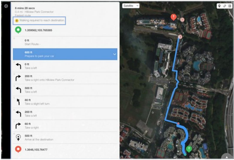
A step in a route that instructs the user to “Prepare to park your car”, and followed by other additional steps, should not be classified as Cars Not Allowed MNE.
As per GL 4.4, when there is a “prepare to park your car” step, we should not be concerned whether a user is legally allowed to park his/her car or not. This guidance is not intended to indicate a specific parking spot, but rather that the user will need to park the vehicle at some point and proceed on foot from that point on. Analysts tend to evaluate such situation as MNE – no legal parking present, which is incorrect.
The route below indicates “prepare to park your car at Simei Park Connector” at Step 4. After which, the user is required to continue walking to reach his/her destination. This route does not have MNE issue.

There are some cases where the step guidance will indicate a road is for pedestrian only (walking is required to reach destination) when it is acceptable to be driven on
An example of this would be the route below:
In this scenario, it is indicated that walking is required (after Step 1 “Prepare to park your car”). However, looking at the route, we can determine that the entire journey is drivable. Hence this route is considered to have a non-MNE issue.
As per Section 3.4 of the Routing Guidelines, when the route has Major
Navigational Issue (MNE), the analyst is required to leave a comment that includes:
Examples of good comments are:
MNE | Comment |
Major Road Misalignment | •On step N, -1.11111111,-2.22222222, route is missing a roundabout larger than 50m. It is considered a major misalignment and is rated as MNE. [link to resource]. •On step N, -1.11111111,-2.22222222, route misses a slip lane/turn channel that measures more than 100m from its start (and/or blue line crosses it more than 50m from its starts). It is considered a major misalignment and is rated as MNE. [link to resource]. •On step N, -1.11111111,-2.22222222, route is more than 50 meters misaligned with real world. Standard and Satellite views and other maps providers were checked and confirm the MNE. [link to resource]. |
Physically impossible | •On step N, -1.11111111,-2.22222222, route takes user to a road that does not exist in real world. It is physically impossible. [link to resource]. •On step N, -1.11111111, -2.22222222, road map has been updated and the manoeuvre is not possible anymore. Standard and Satellite views and other maps providers were checked and confirm the MNE. [link to resource]. |
| • On step N, -1.11111111, -2.22222222, route crosses a physical barrier, as seen on street imagery from December 2020. It is physically impossible. [link to resource]. |
Access restricted | • On step N, -1.11111111, -2.22222222, user cannot access it, as it is a restricted area. The route is does not start there and it is not user’s destination, so it is marked as an MNE. [link to resource]. |
Cars not allowed | • On step N, -1.11111111, -2.22222222, cars cannot access it, as it is a pedestrian area. The route is does not tells user to park the car and walk in this area, so it is marked as an MNE. [link to resource]. |
Against traffic | • On step N, -1.11111111, -2.22222222, route takes user against traffic as seen on street imagery from December 2020, and traffic signs. [link to resource]. |
Illegal U-turn | • On step N, -1.11111111, -2.22222222, route takes user to make an illegal U-turn. [Explain why U-turn is illegal]. [link to resource]. |
Turn restriction | •On step N, -1.11111111, -2.22222222, route takes user to make a right/left turn that is not allowed as seen on street imagery from December 2020 and traffic signs. [link to resource]. •On step N, -1.11111111, -2.22222222, route takes user to make a right/left turn that is not allowed as seen on street imagery from December 2020, continuous yellow line indicates the turn is illegal. [link to resource]. |
Other | • On step N, -1.11111111, -2.22222222, [explain with details what is wrong with the route]. [link to resource]. |