Please verify every turn of a route to see if it is allowed by checking traffic signs and arrows painted on the street. Below more specific cases are discussed.
Source: http://www.ldhighway.com/gallary/Road%20Medians%20&%20Road%20Widening.pdf
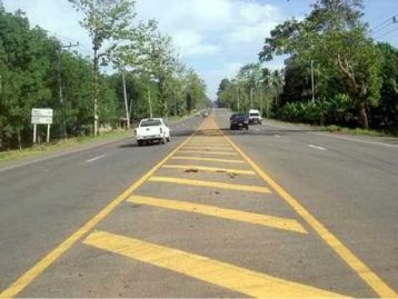
Pay extra attention when the route is in rural area and there is no physical traffic island in between two sides of the street. If the route is navigating along one side of the street, making a turn through painted median is illegal.
For example, a route that makes a turn through painted median in to a sub-street should be marked as Turn Restriction.

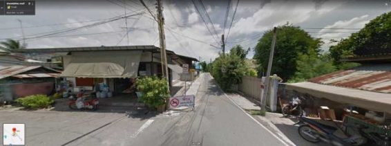
Some of the street doesn’t have turn restriction sign but it does have a painted direction on the street. In this case, the mark on the street at 13.830521, 100.623379 indicates that only left turn is allowed. Hence, the route that is making a right turn at this location should be marked as Turn Restriction.
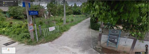
A Physically Impossible should be selected when the route uses roads that do not exist in real life. It’s important to observe the route steps to identify if the street in the suggested step does exist. For example, a route step that navigates through ซอยเจริญนคร 5 (13.725823, 100.509191) sub-street should be marked as Physically Impossible because this sub-street does not exist.
Please conduct further research using various sources to verify if navigating through a certain street is still possible.
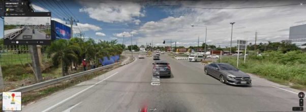
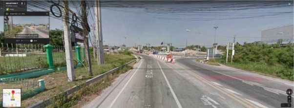
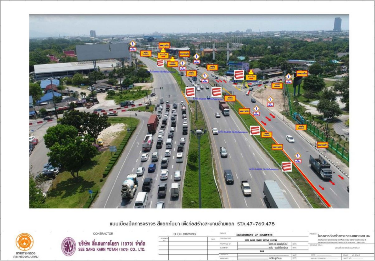
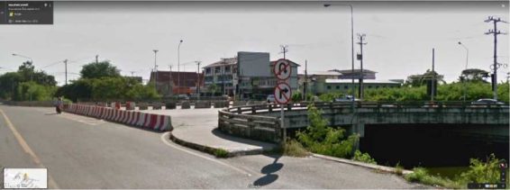
For example, a route is navigating through an intersection that is under construction should be marked Physically Impossible. The แยกทบั มา intersection at 12.704537, 101.241421 can be confirmed by various sources that it’s now blocked by road barriers due to a construction.
Source: https://www.facebook.com/rayonghighway.ry/photos/a.1911346468890015/1911346932223302
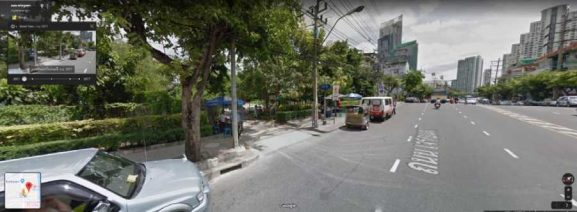
A route has an Against Traffic error when it navigates the wrong way down a street including entering to the destination using an exit.
In this case, if the route navigates to the destination using an exit at 13.735155,100.582402 to make an entrance should be marked as Against traffic.
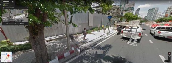
When the route is using a road that does not allow for the usage of a typical car then it should be marked as Car Not Allowed.
In this case, we can see a restriction sign at 13.456602, 101.182318. Cars are prohibited to pass through this street. If the route navigates through this street then is should be marked as Car Not Allowed.
An Access Restriction MNE occurs when a route uses the route during the restricted time.
Please always check the expected time the user would arrive at a step based on the step lengths. The information about timestamp can be found on the query info in the rating tool.
However, if the blue line starts or ends within a restricted access area, we assume that the driver requesting the route has access to the private property and would not consider this as an MNE.

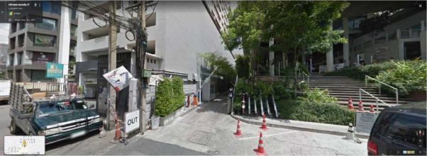
In this case, the route is making a left turn at 13.708337,100.598455 at the end of the sub-street into a private property that the driver would not be allowed to use. This navigational error should be marked as Access Restricted.
In Thailand, U-Turn is not allowed when; ,
Source: http://web.krisdika.go.th/data/law/law2/%A803/%A803-20-9999-update.htm (law section 53)
The road is supposed to have enough space and is safe to perform the U-Turn maneuver.
If after checking all the items and it still can’t verify if the U-turn is legal or not, ask yourself if you would make the U-turn if you were driving. The road is supposed to have enough space and is safe to perform the U-Turn maneuver.

Source: http://www.ldhighway.com/gallary/Road%20Medians%20&%20Road%20Widening.pdf
Similar to section 1.1, making a U-turn through painted median is illegal if the route is making a U- turn through painted median then it should be marked as Illegal U-turn.
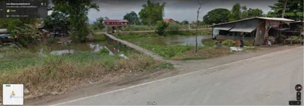
In this case, the route makes a turn to a narrow bridge at 14.15651,100.57635. It is physically impossible for the regular car to drive on, we should select “Physically Impossible”. However, if the car can still drive on but the path is reserved only for bus, motorcycle, pedestrian etc, we will then select “Cars Not Allowed”.
In this case, the route makes a turn or a u-turn to a channel blocked by road barriers. A turn restriction and u-turn restriction sign are also presented at this location. However, we should select the most severe error, so this navigational error should be marked as Physically Impossible.
When an MNE is found, leave a comment that includes:
Example of a good comments:
MNE | Comment |
Major Road Misalignment | On step 1, 1.111111, 2.233333, route is missing a roundabout larger than 50m. [link to resources]. On step 3, 1.111111, 2.233333, route misses a slip lane/turn channel that measures more than 100m from its start(and/or blue line crosses it more than 50m from its starts). [link to resource] On step 12, 1.111111, 2.233333, route is more than 50 meters misaligned with real world. Standard and satellite views and other map providers were checked and confirm the MME. [link to resource] |
Physically impossible | On step 1, 1.111111, 2.233333, route takes the user to a road that does not exist in real world. [link to resource] On step 1, 1.111111, 2.233333, road map has been updated and the maneuver is not possible anymore. [link to resource] On step 1, 1.111111, 2.233333, route crosses a physical barrier, as seen on street imagery from December 2019. [link to resource] |
Access restricted | On step 1, 1.111111, 2.233333, user cannot access it, as it is a restricted area. The route doesn’t start there and it is not user’s destination. [link to resource] |
Car not allowed | On step 1, 1.111111, 2.233333, cars cannot access it, as it is a pedestrian area. The route doesn’t tell users to park the car and walk in this area, so it is marked as a MNE. [link to resource] |
Against traffic | On step 1, 1.111111, 2.233333, route takes user against traffic as seen on street imagery from December 2019, and traffic sign. [link to resource] |
Illegal U-turn | On step 1, 1.111111, 2.233333, route takes user to make an illegal U-turn. [explain why U-turn is illegal]. [link to resource] |
Turn restriction | On step 1, 1.111111, 2.233333, route takes user to make a right/left turn that is not allowed as seen on street imagery from December 2019 and traffic sign. [link to resource] On step 1, 1.111111, 2.233333, route takes user to make a right/left turn that is not allowed as seen on street imagery from December 2019, continuous yellow line indicates the turn is illegal. [link to resource] |
Other | On step 1, 1.111111, 2.233333, [explain with details what is wrong with the route]. [link to resource] |
When a Non-MNE is found, leave a comment that includes: