This document describes common mistakes found in Pedestrian tasks and tips on how to avoid them.
Before we go into the common mistakes, it is worth highlighting Section 3 of the Pedestrian guidelines.
Section 3.1 outlines the process of following the route inch-by-inch from start to finish using satellite or hybrid map layers. This method is the most effective way to identify errors in a route. You should keep an eye out for:
5. Other Oddities
Section 3.2. details the importance of performing deep dives on key locations.
One effective method to ensure route and map accuracy is to search for recent, street-level pictures of the
road. The best sources of this imagery will be street imagery services. Utilizing these services to see the road allows you to view the road from the perspective of a ground-level user. It can provide insight into the actual conditions of the road, road safety considerations, speed limits, and more.
Street imagery services are not the only sources of useful information. Any photograph of the road, whether found on image hosting platforms or business review websites, can be used as long as the imagery helps you understand the current or recent state of the road.
You should look for street-level imagery in areas where it appears there might not be safe walking paths or where roads seem to be unsuitable for pedestrians.
Similarly, in certain situations, referring to individual POI maps can be beneficial. For instance, if the route leads into a university or a shopping mall and you suspect that the satellite imagery and standard map might be outdated, quickly checking if the university or mall provides a visitor map can help confirm the accuracy of the depicted roads.
While this level of research isn’t necessary for every section of the map, it’s advisable to scrutinize any areas that appear questionable during your inch-by-inch review, including step changes. Satellite imagery alone may not always identify issues related to turn and access restrictions.
Per section 2.2.3. A route should be rated as having an Access Restriction if it passes through an area, including private property and indoor areas, that would typically be safe and legal for a pedestrian to use but signage or time-of-day laws prevent pedestrian usage. An Access Restriction occurs whenever a route navigates through a private road or property that are not associated with the Start or End Points on the Pedestrian Route Line.
Key things to note:
that area.
Access Restriction Common Mistake 1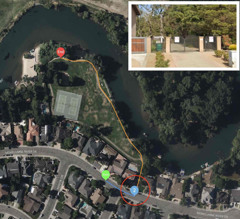
In this example, step 2 navigates through a locked gate. This gate provides private access to a river, park, tennis courts, and other amenities. Since the route ends in a private area, it should be assumed the user has access to this area.
Access Restriction Common Mistake 2
In this example, the route makes a right into Derby Street at step 3. Streetview shows Derby Street is a dead-end street and there is a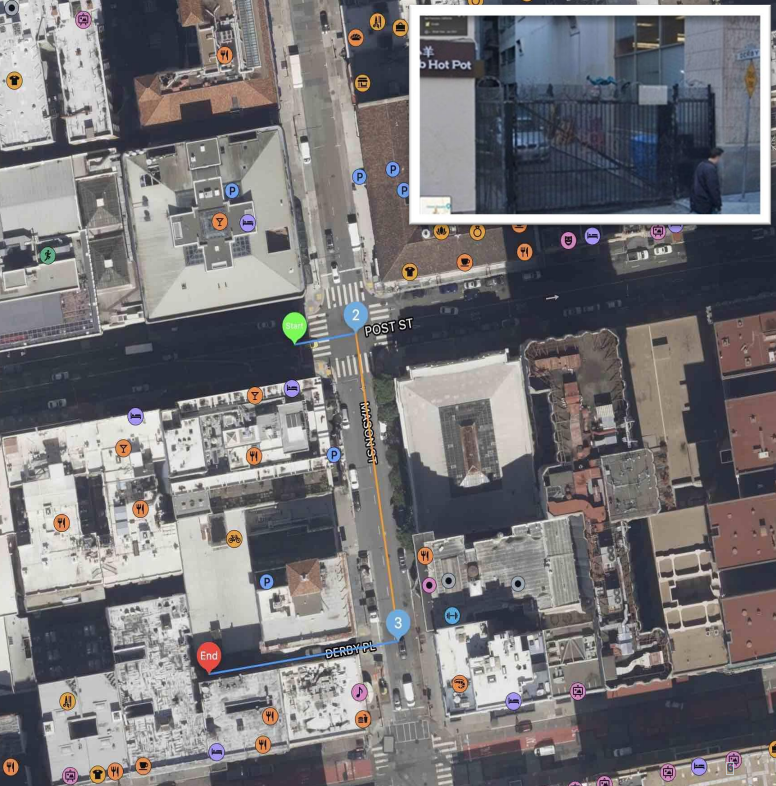 locked gate. The route ends in Derby Street and it should be assumed the user has access to this area.
Access Restriction Common Mistake 3
In the example on the right, the route travels into S Mirror Lake Drive at step 3, through some barrier gates. The route ends in this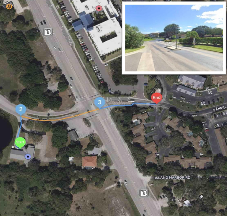 private area. It should be assumed the user has access to this area.
Access Restriction Common Mistake 4
In the task on the right, the route starts by passing through a parking lot owned by FedEx but doesn’t end there. Per section 2.3.3. if a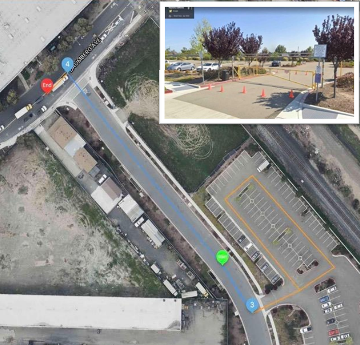 route travels through a parking lot that is located on private property and is not meant for public use or is otherwise not publicly accessible, MNE – Access Restricted should be selected. Non-publicly accessible parking lots include any lot that has signage, gates, or security that restrict public access, as well as paid parking garages/lots that are only intended for persons who have paid to park on the premises.
Access Restriction Common Mistake 5
In this example, the route travels along a golf course. At step 9, the route passes through a private drive, and then leaves the neighborhood. Since public access to this step of the route is explicitly restricted, this route should be rated as having an Access Restriction.
Access Restriction Common Mistake 6
In this example, the route starts at the shared parking lot and then passes through a parking lot that is restricted to use by Planet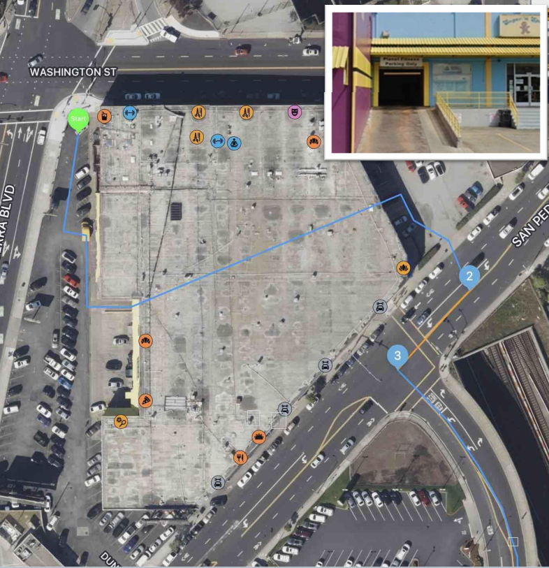 Fitness customers only as seen in the second image. The route does not begin or end at this parking lot and we cannot assume that the user has access to this area, so the route should be flagged as having an Access Restriction.
Access Restriction Common Mistake 7
At step 3 in the task on the right, the route turns right into a road with gates at both ends however, the route doesn’t end there. A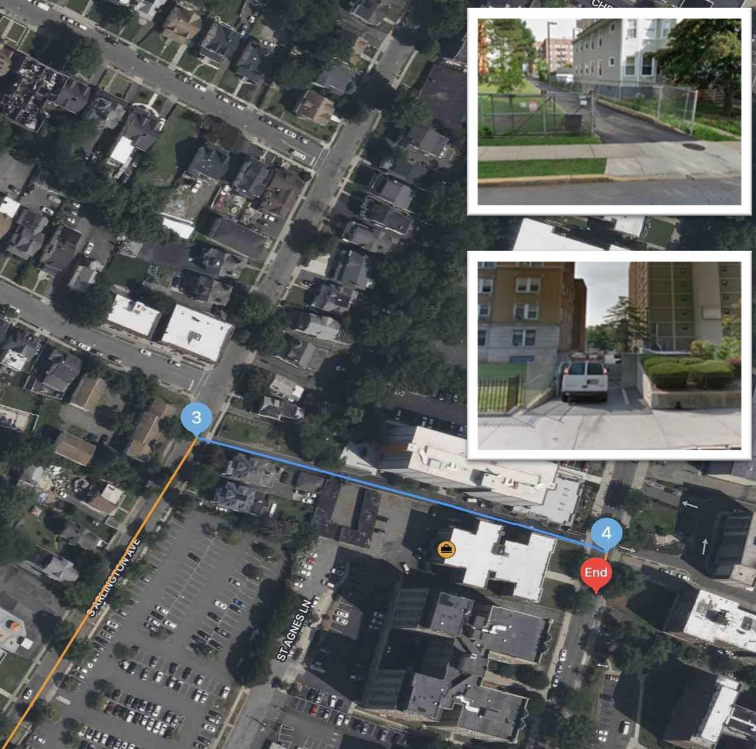 route that navigates through, but does not begin or end in, a private road is considered to have an access restriction as we cannot assume an average user would be allowed access to walk through the road.
Access Restriction Common Mistake 8
In the task on the right, it is important to pay attention to the Timestamp. The Timestamp is used to determine time- based access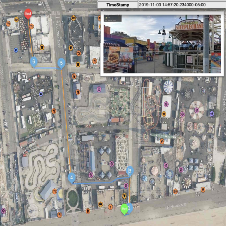 restrictions. Research shows Luna Park and Deno’s Wonder Wheel amusement park closed back in October 2019 and never opened in 2020 because of COVID-19. At step 3, the route passes through a path with a gate. The user requested this route on November 3, 2019, so the gates were closed on that day. The route is restricted by locked gates and it doesn’t begin or end within this restricted area, it should be rated as having an Access Restriction.
Access Restriction Common Mistake 9
In this example, the pedestrian route travels through the private property of a business at step 11. There is a “Shipping and Receiving
” sign. If it is not meant for public use or is otherwise not publicly accessible, MNE – Access Restricted should be selected.
Access Restriction Common Mistake 10
At the beginning of the task on the right, the route navigates through a gated community but doesn’t end there. A route that navigates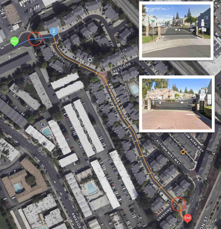 through, but does not begin or end in, a private road is considered to have an Access Restriction as we cannot assume an average user would be allowed access to walk through the road. The red circles in the image show where the gates are located.
Access Restriction Common Mistake 11
At step 3, the route navigates through a gated community but doesn’t end there. A route that navigates through, but does not begin or end in, a private road is considered to have an Access Restriction as we cannot assume an average user would be allowed access to walk through the road. The red circles in the image show where the gates are located.
Unsafe/Illegal Crossing
Per section 2.1.1 – Any street that a user is required to cross must be safe and legal to cross. Crosswalks, or other safe and legal areas to cross the street, including underground walkways, should be within 50 meters of the nearest pedestrian walkway or an intersection on the route.
If you are unable to determine if a road crossing is safe, a road that meets both of the following conditions may be considered to be pedestrian-friendly:
• Fewer than 4 lanes of traffic
• Speed limits under 45 mph (75 km/h)
Unsafe/Illegal Crossing Common Mistake 1
In this task, the route crosses 4 lanes of traffic and the nearest safe crossing, a light-controlled intersection, is more than 50 meters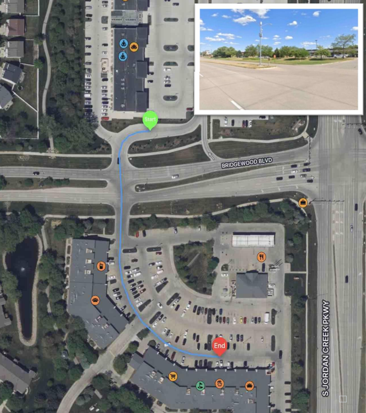 away. The route is also missing subtle indications that the crossing is safe such as wheelchair- accessible curb ramps that are usable in the direction of travel. This is an Unsafe/Illegal Crossing.
Unsafe/Illegal Crossing Common Mistake 2
In the task on the right, the route crosses 4 lanes of traffic, between steps 2 and 3. The speed limit on this road is 50 mph. Since there is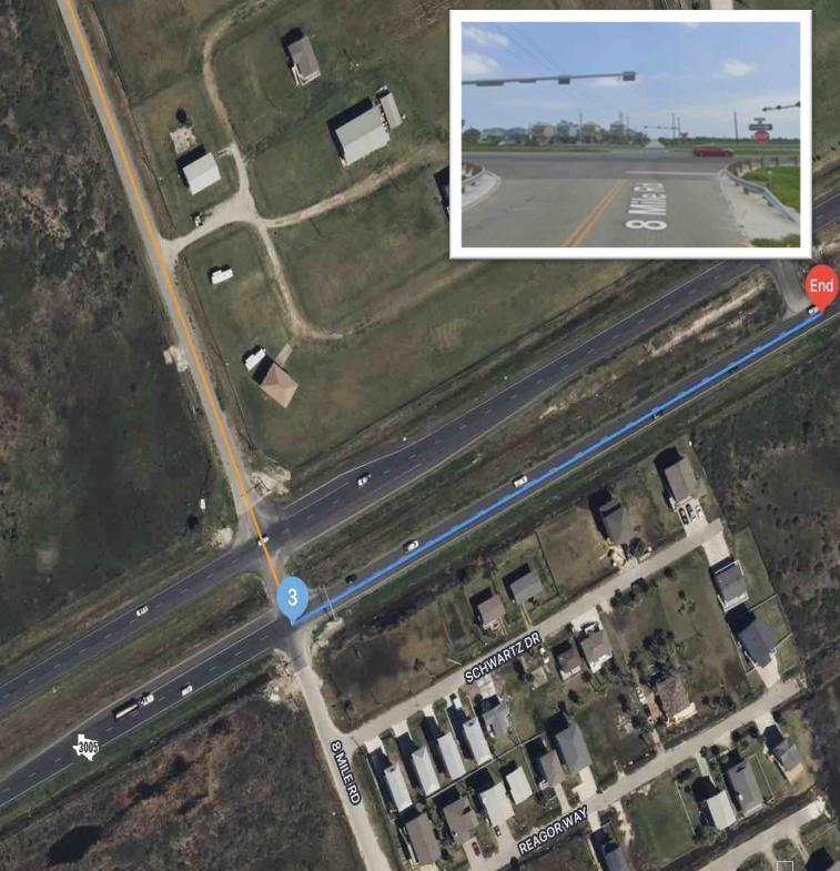 no crosswalk, or other safe and legal space to cross the street, within 50 meters of this crossing, this should be considered an Unsafe/Illegal Crossing.
Unsafe/Illegal Crossing Common Mistake 3
In the task on the right, the route crosses 4 lanes of traffic, betweensteps 4 and 5. Street and satellite imagery safe shows a safe way to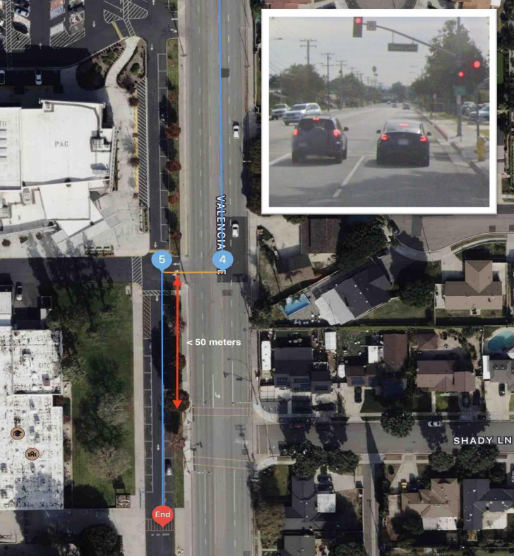 cross the street within 50 meters of this point. This should NOT be considered an Unsafe/Illegal Crossing.
Unsafe/Illegal Walkway
Per section 2.2.2. – Pedestrian routes should use walkways that are safe and legal to walk along. Common pedestrian-friendly walkways include sidewalks, pedestrian paths, underground walkways, the sides of the street on low-speed roads, and large pedestrian-friendly medians.
If you are unable to determine if a road crossing is safe, a road that meets both of the following conditions may be considered to be pedestrian-friendly:
Key things to note:
• For low-speed roads, such as neighborhoods, we can expect that it would always be safe to walk along a road regardless of the presence of a sidewalk or similar pedestrian feature.
• For roads with higher speeds, we expect some pedestrian-safe and legal area to walk such as a sidewalk, pedestrian-specific path, or a large grassy shoulder on the side of the road.
Unsafe/Illegal Walkway Common Mistake 1
In this example, there is a sidewalk on the north side of Rogers Avenue. However, there is no sidewalk along the south side of Rogers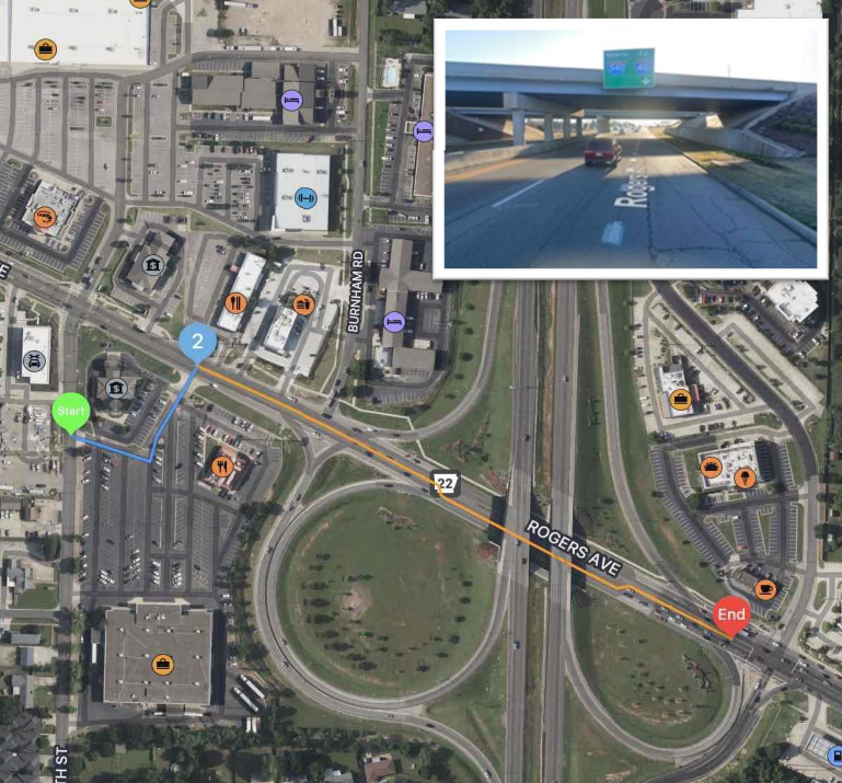 Avenue. The closest sidewalk is more than 50 meters away from the route line. Walking along this route would be unsafe and should be rated as an Unsafe/Illegal Walkway.
Unsafe/Illegal Walkway Common Mistake 2
In the task on the right, the street imagery reveals there is no pedestrian walkway along most of the route. Walking along this route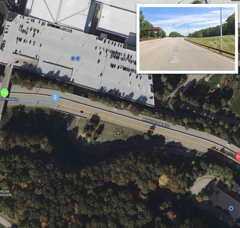 would be unsafe and should be rated as an Unsafe/Illegal Walkway.
Unsafe/Illegal Walkway Common Mistake 3
In this example, there is no sidewalk along the route between steps 2 and 3. This route includes the James H. Pruitt Memorial Bridge.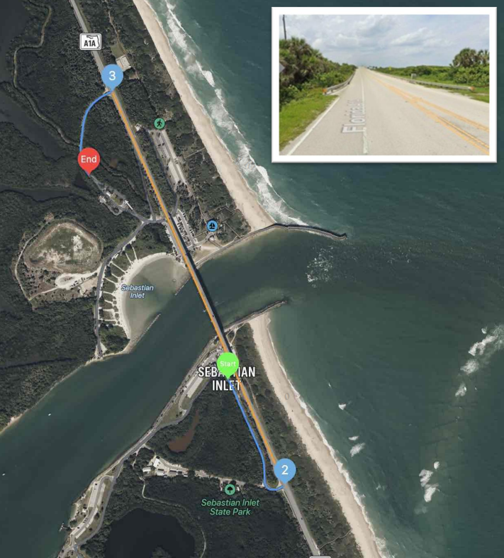 The vehicular speed limit is 50 mph. Due to the high speed of traffic and lack of sidewalks, this route should be rated as an Unsafe/Illegal Walkway.
Unsafe/Illegal Walkway Common Mistake 4
Research using street and satellite imagery reveals that there is no pedestrian walkway between steps 1 and 8 of the route. A large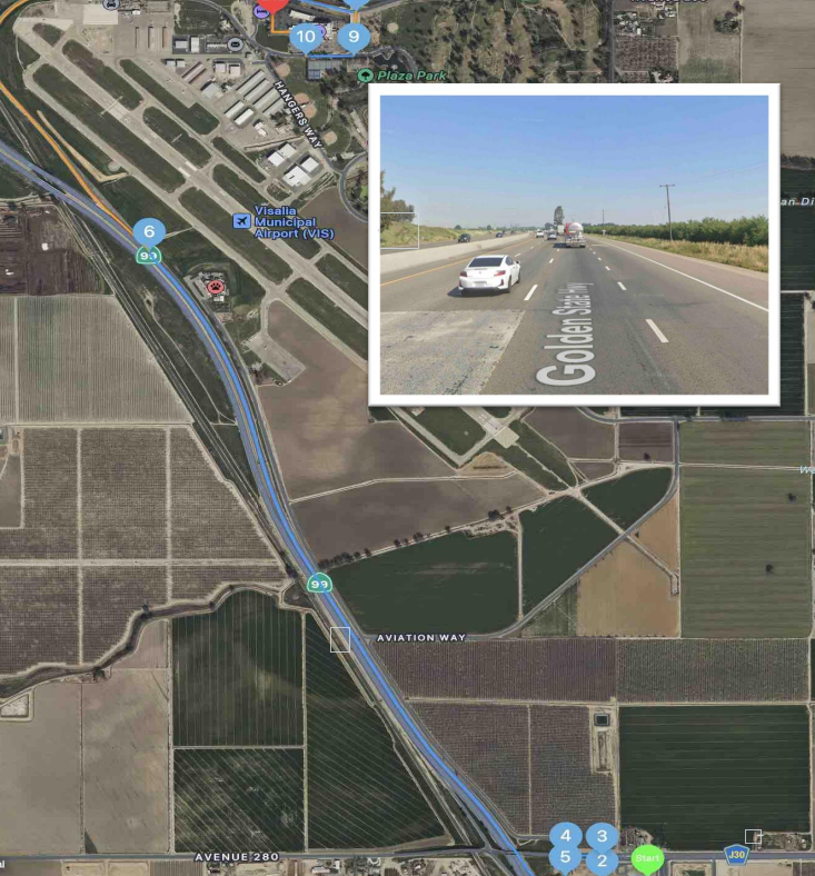 stretch of the route is on a highway. Due to the high speed of traffic and lack of sidewalks, this route should be rated as an Unsafe/Illegal Walkway.
.