This document will give you a quick overview of common mistakes made when rating routing tasks, and how to avoid and identify them.
Some routes direct the driver to perform a U-Turn. In some cases, these U-Turns turn out to be illegal or unsafe. If the step list commands a U-Turn, try to find images of the ground situation. Look out for signs that forbid U-Turns:
 Tips for your rating decision:
Look for ‘U-Turn not allowed’ signs
Is there enough space for a U-Turn?
Are there tram tracks or street markings?
Is a left turn allowed?
Use common sense and your instinct
A U-Turn not forbidden by signage does not automatically indicate it is legal or safe. Use your common sense or apply traffic laws to decide if a U-Turn is safe & legal.
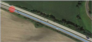
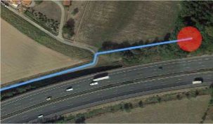
Example1: In Step 0, the step list instructs the driver to make a U-turn at the start of the route and proceed in the opposite direction. Please note: At the start of the route, the blue route line does not need to follow this maneuver! We have to make sure that the U-turn at the start of the route is legal and safe. In this case, the step list asks the driver to make a U-turn on a highway; this is not permitted in Germany.
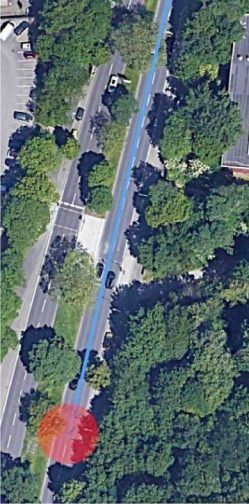
Example 2: The same applies to regular streets if there is not enough space to perform a safe U-turn, and/or if it would be dangerous to do so. At the start of the route, the driver is instructed to make a U-turn and proceed northward. Making a U-turn at this location would be dangerous since there is not enough space to perform the maneuver, thus creating a dangerous situation.
Physically Impossible MNEs occur when a route uses roads that does not exist or instructs the driver to perform impossible maneuvers.
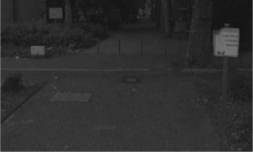
Example 1: Going north, the route asks the driver to take a left turn at 50.906586,6.963755. At first glance, satellite imagery does not appear to reveal anything unusual. Checking street imagery, we immediately notice that poles block the route. We can also see ‘fire lane’ signage. The signage only disallows blocking the road by, e.g., parking; access is allowed, but is made physically impossible by the poles. Please be sure to deep dive on every step change; do not rely on satellite imagery alone. Also, check geoportal.de, OpenStreetMap and other maps applications as they may provide additional information.

Example 2: Starting at 52.222436,9.019225, the route instructs the driver to proceed
westward. Maps applications and satellite imagery do not show a regular road at this location. The route asks the driver to use a dirt road. We consider this maneuver a Physically Impossible MNE.
Please see GL 4.2. Physically Impossible for additional examples and explanations.
Sometimes, traffic regulations change outside of step changes. This can be tricky to spot, so please be sure to keep an eye out for any hints that might indicate such instances on satellite imagery.
Example: Driving eastward, the driver is instructed to take a right turn going south at 50.118845,8.660613. On satellite imagery, we can see that all of the cars are facing in this direction, which suggests that the route is entering into one-way street in the right direction.
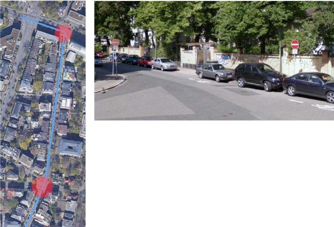
At 50.116177,8.659888, the route passes over a crossing and continues straight ahead. However, in this section of the street, all of the parked cars are facing in the opposite direction. Checking street imagery, we can see that the route instructs the driver to proceed into a one-way street in the wrong direction.
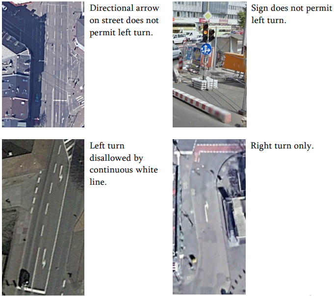
A Turn Restriction MNE should be indicated when the route instructs the driver to make a turn that is physically possible, but disallowed by signage or other restrictions. Good indicators of turn restrictions are signs/directional arrows painted on the street. Sometimes the signs/arrows are not clearly visible on satellite view or hidden by other objects, e.g. cars. Please check different maps applications and always be sure to make a thorough analysis of the ground truth. Here are some examples: