This document will provide both resources and techniques for conducting research in New Zealand. The New Zealand Post Address Finder & The Land Information New Zealand (LINZ) GIS Map are the two resources that are the focal point for this document. New Zealand has multiple government mapping resources that can be used in conjunction with LINZ & the NZ Post Address Finder when conducting research in New Zealand. The use of these tools will ensure accuracy and consistency across the market.
The New Zealand Address and Postcode finder is useful for verifying both postal codes and addresses in New Zealand. The New Zealand Post Address Finder contains information for New Zealand postal addresses, rural delivery addresses, postcode areas, PO Box and Private Bag numbers. The Address & Postcode Finder is a good source for verifying essential address components and ensuring correct formatting of addresses in New Zealand
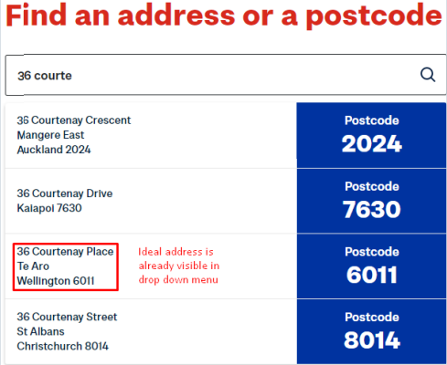
When searching for a full address in the Address and Postcode finder it is best to search by typing out the address rather than just copying and pasting the query address into the search bar, the Address Finder will offer suggestions as you type. You can select an address from the dropdown menu if it appears or continue to type until the ideal address appears. This is a useful way to search for an address, ensuring that the ideal address is returned and not omitted from the result due to a formatting or spelling issue.
Example
Address: 36 Courtenay Place, Te Aro Wellington 6011
We only have to type the street number and a partial street name into the Address & Postcode Finder before the ideal address is suggested.
8014
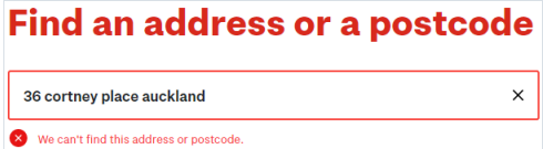
It is best to use the Address & Postcode autocomplete function if unsure of the address spelling/format. If you copy and paste the same address over with a spelling error or incorrect locality the ideal result may be omitted.
2.1.2 Addresses that do not receive Mail Delivery
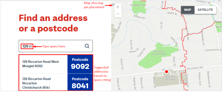
Not all New Zealand addresses receive standard mail delivery. Some addresses will receive mail via a PO Box or Private Bag. NZ Post Address & Postcode Finder will still verify that these addresses exist however they will be followed by the comment “This address doesn’t receive Standard Mail delivery.” Disregard the “This address doesn’t receive Standard Mail delivery” as it does not impact the validity of the address.
Example
Address: 129 Riccarton Road, Riccarton, Christchurch 8041
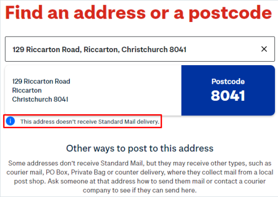
This address is valid, it is the address for Westfield Riccarton https://www.westfield.co.nz/riccarton The fact that an address does not accept standard postal delivery does not affect the address validity.
The LINZ GIS Data Map is a great resource to use to verify addresses & pin
placement in NZ. Land Information New Zealand (LINZ) is the government department responsible for land titles, geodetic and cadastral survey systems, topographic information, hydrographic information, and managing Crown property in NZ. Using the data sets provided by LINZ we have access to both address information and recent satellite imagery that allow us to verify data in New Zealand.
URL: https://data.linz.govt.nz/search/
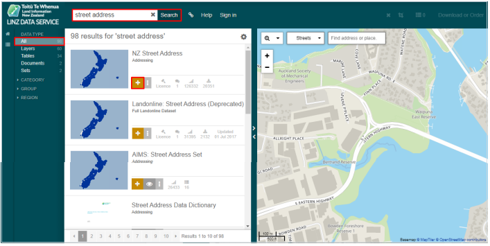
In order to use LINZ we must add the street address layer. Select All under Data Type then search for Street Address in the top left search box. Click on the + icon in order to add this layer to the map.
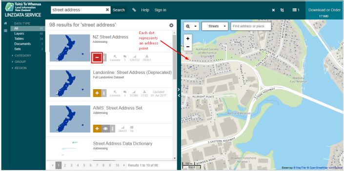
The + will show as a – when the layer has been added. Please note that the correct layer to add is “NZ Street Address”. Once this layer has been added address points will be represented by a dot on the Map.
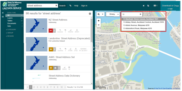
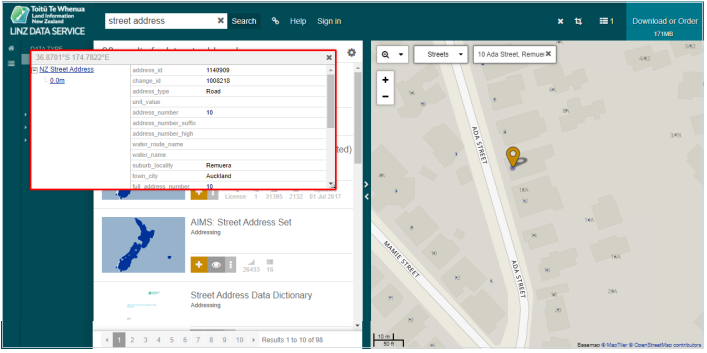
Once you have completed the initial setup you are ready to search. To Search start typing an address. LINZ will offer suggestions as you type, you can select an address from the dropdown menu if it appears or continue to type out the whole address.When an address is verified as valid a pin will appear on the map. Click on the dot near the pin and a pop-up box will appear with address information. Ensure the dot you have clicked on corresponds to the address you are searching for.
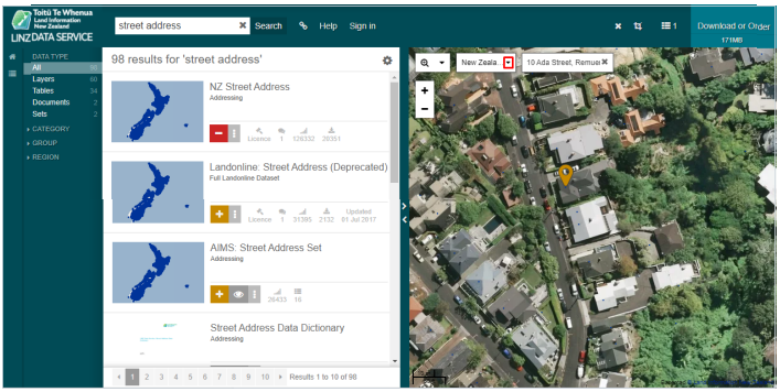
Once confirmed you can toggle between streets and satellite imagery or New Zealand Aerial Imagery using the arrow on the top left of the map next to “Streets.” This will enable you to view rooftops and property boundaries in order to verify pin placement.
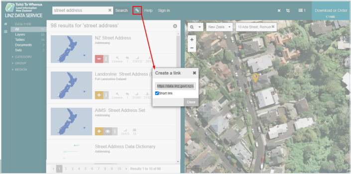
LINZ also allows you to create a short URL to the map by clicking on the link icon. Links to the LINZ map should always be left in the comment section if you use LINZ to verify address components and/or pin placement.
• If the query address is misspelled or incorrectly formatted LINZ will not return a response address. The NZ Post Address Finder is a useful tool to
verify the existence, format and spelling of an address when LINZ does not recognise a queried address.
More information on search tips and the LINZ datasets available can be found here: https://www.linz.govt.nz/data/linz-data-service/getting-started-lds
The NZ Government also has multiple other government maps available that can be used alongside LINZ and NZ Post to verify data. A list of these resources is included below.
URL: http://maps.doc.govt.nz/mapviewer/index.html?viewer=docmaps
URL: https://geomapspublic.aucklandcouncil.govt.nz/viewer/index.html
URL: https://mapviewer.canterburymaps.govt.nz/
URL: https://maps.gdc.govt.nz/
URL:https://gis.westcoast.govt.nz/WestMapsViewer/?map=70b9aabf07df4725 97cee0afbc29e5f3
Proprietary map services (such as Google, Bing, Yandex etc) should never be used independently to verify data however it is a good resource to use as a starting point or when crosschecking data with New Zealand Post, LINZ and/or other government maps providers. There are some features that can be leveraged when verifying data particularly when establishing the proximity and prevalence of results in relation to the user, viewport or requested locality.
Search Nearby in Google Maps can be a useful feature to identify the number of real-world matches that exist in a specific area. The “Nearby” function allows the user to specify a single location and then search for POI’s, Chain Businesses or Categories nearby. This function is useful as it gives you a quick visual representation of possible results that could match the query and that may not be displayed in TryRating.
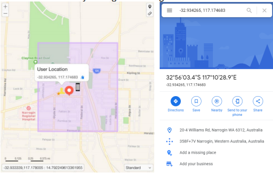
For queries where the viewport location or the user location are the location intent, we can use coordinates to perform the search. The coordinates are displayed like this in TryRating:
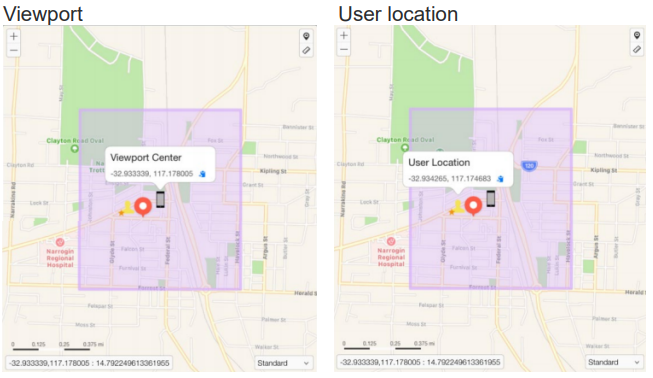
Once you have determined if the User Location or Viewport is the location intent copy the relative coordinates and paste them into Google Maps. Then click the “Nearby” button, this empties the search field allowing us to write our query:
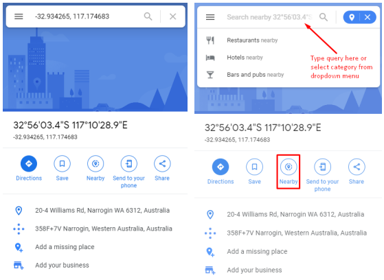
This function can also be used when the location intent is a locality. For queries such as “Cafés Perth” we simply search for Perth first, then click the Nearby button, which empties the search field, allowing us to input the query café and search for cafes in/nearby Perth.
You should always crosscheck the validity of the returned results with their official websites or claimed social media pages to ensure that they exist / are still open as Google data is not always reliable and therefore can’t be used as a primary resource.
Partial addresses are often returned in Autocomplete. The routing functions
found in many map applications can assist us by enabling us to find potential address matches to the query string.
Firstly we need to open a map application like Bing or Google and paste the user or viewport coordinates (depending on the user’s location intent) as our starting point. For this example assume that the user location is the location intent and the query is 421.
User location in TryRating and Google
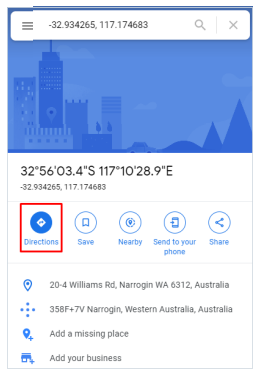
When you have entered the coordinates click on the Directions button. This will start the routing function.
The next step is to click the two arrows to the right of the search fields. This will make the user location coordinates that we entered the starting point for the route. Now that we have a starting point, we can start typing the user’s query string into the destination field and see what is returned as autocomplete options for the query.
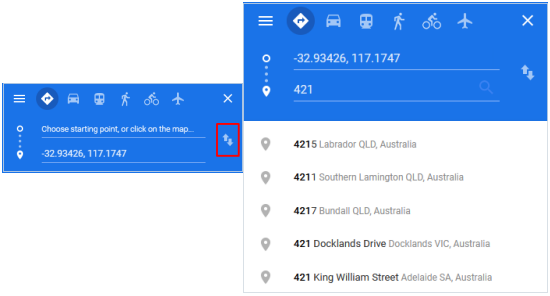
Check the suggested response addresses in relation to both distance and validity and use the information provided to influence your rating in TryRating. While all map applications will try to return valid addresses, they don’t always succeed. Always confirm an address exists using LINZ, NZ Post Address &
Postcode Finder or other government map resources.
k
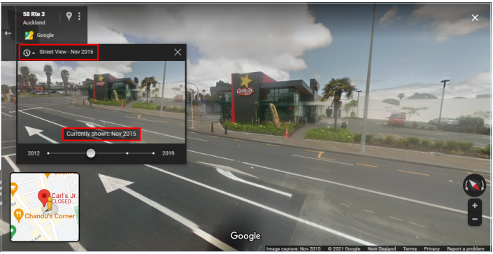
Street Level imagery is useful to use in collaboration with official sources to verify the existence of a POI/ Address as well as pin placement. Street View also has a feature which allows you to look back in time which can help when verifying if a business was once at this location but has now closed/relocated.
Example:
Carl’s Jr Otahuhu
101 Atkinson Avenue, Otahuhu, Auckland 1062
https://www.nzherald.co.nz/business/news/article.cfm?c_id=3&objectid=11779
Carl’s Jr no longer exists in Otahuhu, which we can verify through the official store locator and a secondary resource. If this closure was hard to confirm and we only had a secondary resource claiming this branch was closed, street imagery could be used in collaboration with a secondary resource to verify the business closure.
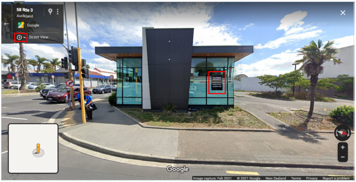
Investigating further if we click on the clock icon, we can look back at previous street level imagery. We can see through the article linked above that the Carls Jr store closed in September 2017 so we need to look before that date. If we look at the street imagery for November 2015, we can see that there was a Carls Jnr at this location that is no longer visible using street level imagery, further verifying that the business is closed.