4. Safety Examples
This section describes some common safety scenarios you will encounter when rating pedestrian routing and how to distinguish between the error types: Unsafe/Illegal Crossing and Unsafe/Illegal Walkway. These are simplified cases intended to demonstrate the error types. When rating, you will often see these occurring on roads that are significantly longer and more complex.
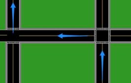
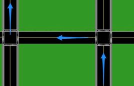
In all of the cases below, a user enters the visible portion of the route from the South, following the blue arrow in the bottom right corner, and is then asked to turn left at the intersection. In several of the examples, the route will be expanded to ask the user to take a second step.
 Case 1: Crosswalks and Sidewalks on All Sides
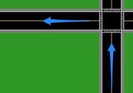
There are crosswalks available allowing a user to travel on either side of the road. You should keep a look out for safety and legality issues later on in the route, but there are none visible in this image.
Case 2: Missing Sidewalk on One Side of Road
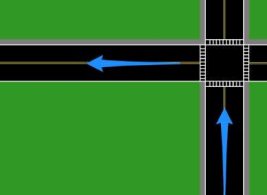 In this case, there is only a sidewalk on the northern side of the road and there are crosswalks available allowing a user to travel on either side of the road.
If any safety or legal issues are discovered on the northern side of the road you should then determine if the southern side of the road is safe and legal to walk along. Even though it does not have a dedicated sidewalk, local laws and traditions may not forbid walking along the southern side of the road if there is enough room to walk safely.
Case 3: Irregular Sidewalk Access
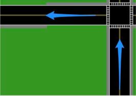 There is only partial access to sidewalks on the North and South sides of the road. For a user to stay on the sidewalk for the entire portion of the route, they’ll need to begin on the North sidewalk and then cross to the South sidewalk halfway along the step.
If the road is unsafe or illegal to cross without a crosswalk and it is unsafe/illegal for the user to walk on the grass in this area on both sides, then rate this as Unsafe/Illegal Walkway.
Case 4: One Side of the Road Loses Its Sidewalk
 In this example, the user is entering on the bottom right, turning left at the West facing arrow, and then turning right at the North facing arrow on the left side of the image.
There is initially a sidewalk available on the southern side of the road. However, that sidewalk does not continue all the way to the next street. Because there is a sidewalk that exists throughout the entire street that the user could be using, this is not considered an Unsafe/Illegal Walkway Error.
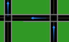
 Case 5: Most Convenient Route Does Not Have Safe Crossing
In this example, the user is entering on the bottom right, turning left at the West facing arrow, and then turning right at the North facing arrow on the left side of the image.
The first intersection has crosswalks available, allowing the user to either cross to the northern half of the road or continue along the southern half.
However, in this case, there is no crosswalk available at the second intersection to allow the user to cross to the North side if they are on the Southern side.
We do not consider this to be an Unsafe/Illegal Crossing as the user may already be on the correct side of the road.
 Case 6: No Sidewalk
In this example, the user turns left onto a road that has no sidewalk. The rating for a case like this will depend on road speed, locale laws, and locale expectations. If this is a high-speed road and there is no safe area alongside the road to walk or if locale laws/convention forbids it, this should be rated Illegal/Unsafe Walkway.
5. FAQ
When you have conflicting information, base your decision on the most recent information available. For example, if street-level imagery shows an intersection with a crosswalk but recent satellite imagery shows no crosswalk, you can reasonably conclude that the crosswalk has been removed at some point. As such, you will need to evaluate the road’s safety to cross without the presence of a crosswalk. If you are unable to determine the recency of satellite or street imagery, refer to other online sources and base your ratings on the most recent information available.
Rate against the most recent road geometry you can find. The time of day and the day of week are important when considering access restrictions. Some pedestrian walkways may also be effected by seasonal restrictions.
You only need to indicate the first MNE that you discover on the route. The MNE selected should be for the first MNE found in the route and, if multiple MNEs apply in a single location, your selection should reflect the most severe error.
This does not qualify as a MNE. When rating Pedestrian Routing, we presume that the start and end points of the Route Line are acceptable to the user and the Route Line is rated independently from the origin/destination pins.
Yes. If there is an existing ferry route that the user could use, then the route is allowed to begin on a ferry. Routes that begin on a ferry will usually not have an initial step indicating the route is beginning on a ferry (the advisory notice may still appear). When
28
trying to determine if the route is beginning on a ferry, look at where it connects to land. If the route is not connecting to land at a ferry terminal, it’s almost certainly not a ferry.
If a route appears to have a MNE, but an underground walkway is present within 50 meters of the route and would allow the user to continue walking along the route, this should not be considered a MNE. For example, if a crossing appears to be illegal or unsafe in satellite and street imagery, but a nearby underground walkway would allow the user to legally and safely cross the intersection, then this would not be considered a MNE. In these cases, you can assume that the route uses the underground walkway to safely follow the route.