Start by copy pasting the route into another map applications to get a quick overview of where there are deviations. Focus on investigating these deviations, especially if they are ranking high on the “potential error list”. But be aware of situations where the difference is just from a different preference of route, some map applications just seem to prefer certain type of roads etc. If you do not recognize what is an obvious preference difference, you can end up doing a lot of unnecessary investigation where there is no real issue.
Sometimes adding 1-2 extra stops can get around this issue and then compare like for like routes with less “normal” deviations.
Approach rating efficiently by evaluating the route and identifying the high-risk areas. Start by looking at these for an MNE. What are high risk areas?
Obviously, you should not rule out anything but spending time on these, instead of tracking the routing along a major road, especially rural ones, where perhaps two other map applications agree with the routing, is simply more effective way of evaluating the route.
Misalignments are considered MNEs when the misalignment is more than 50 meters from blue route line to the ’present day’ ground truth. It is very common for the blue route line to be misaligned along long stretches of the route. It is very important to scan thoroughly even the sections that follow major roads without turns. Often the misalignment is less than 50 meters, in which case it should be rated as a minor issue, but the misalignment distance should always be measured. If it is more than 50 meters, a comment and the coordinates are required. This is one type of misalignment. See the Guidelines section 4.1.1. for the definitions of the other types.
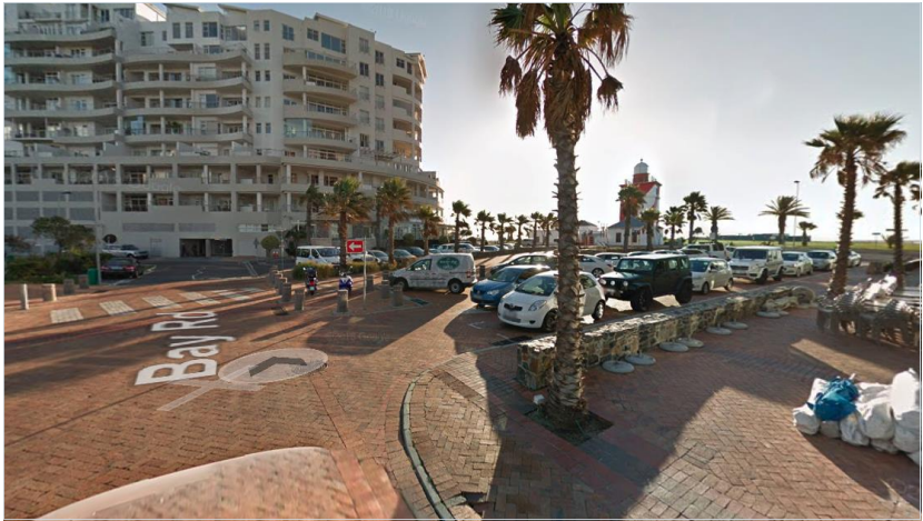
Whenever the route leads the driver into a street but against the traffic, we have an MNE- Against the Traffic issue. This type of routing mistake can be verified only with street level imagery. For this reason, an analyst should always check the points, where a driver is instructed to perform a maneuver or change direction, for restrictions.
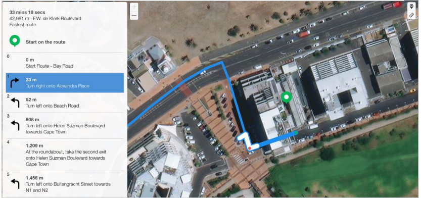
The user is navigated down Alexandra Place. This is a one-way street, verified using satellite and street level imagery. This route should be rated as MNE – Against Traffic.
We face a Turn Restriction issue when the routing instructs the driver to make a turn that is physically possible but isn’t allowed by signage or other restrictions. That’s why when the routing instructs the driver to make a turn it is essential to
look for the existence of restrictions (signs, painted arrows) in street imagery.
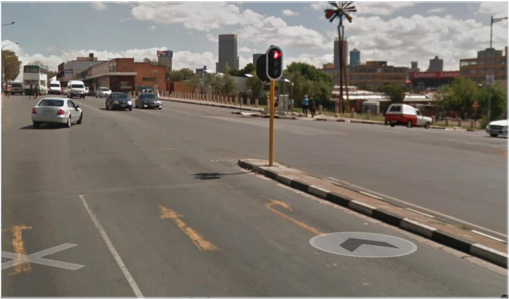
When there is a U-Turn in a route, the location needs to be checked to see if there is a problem with this manoeuvre. Often a U-turn appears in the beginning of the route. U-Turns can be prohibited with a specific sign or country road laws. It is also prohibited when there is 2 solid lines painted on the road.
The Road Traffic Act in South Africa has specific legislation making it illegal to make a U-turn on a highway.
https://www.wheels24.co.za/News/Peril-on-the-road-The-killer-U-turn- 20141231
Just because there is no sign indicating that a U-turn is illegal, does not mean that U-turns are permitted. Even when there are no signs clearly prohibiting a U-turn, you can expect to find it illegal on most roads at the following locations:
_ . , . , , . , , , , , .
The arrive alive website also states that a U-turn is illegal where there is a traffic light
https://www.arrivealive.mobi/the-u-turn-as-a-threat-to-road-safety
Take extra care verifying if a U-turn is legal by checking:
If after checking all the items you cannot say if the U-turn is legal or not, ask yourself if you would make the U-turn if you were driving. Would you feel unsafe? Would you be concerned the police would find the action wrong? If you answer Yes to any of these questions, rate it as an MNE.
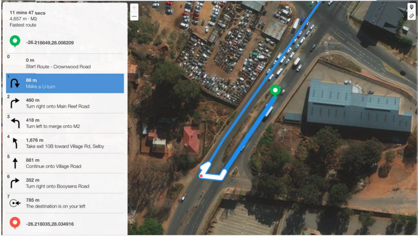
In this task the user is asked to perform a U-Turn at step 1. We can see below that the U-Turn is illegal as it is in close proximity to a curve in the road where approaching traffic from either direction cannot be seen. MNE – Illegal U-Turn
When the route instructs the driver to use a road that doesn’t exist in real world or perform a maneuver that is not possible due to physical barriers, we have an MNE – Physically Impossible issue. For instance, if the route shows that the car should pass over a pavement that divides two lanes, we have an MNE – Physically Impossible.
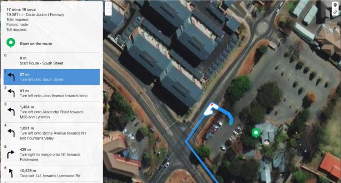
Initial step turning left onto South Street from the carpark is physically impossible. The entrance/exit to the carpark is located further down the road. This result should be rated Physically impossible as the route uses a road that do not exist in real life
Sometimes the route instructs the driver to use a street that doesn’t exist, or it is a street only for pedestrians, buses. In such a case besides the satellite or street imagery we have to check the step list and the given instructions. If a specific step informs the driver on time that he has to park the car, he knows that he has to walk for the rest of the route.
Some routes include a pedestrian part, which is indicated in the instructions, so the route is rated normally. You’ll need to check the steps to see if they mention Prepare to Park or any other instruction related to Walking. Mainly in the cases where route takes user to where cars are not allowed.
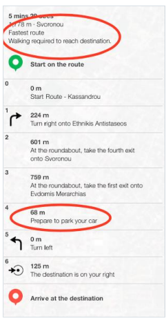 On step 5, we can see that cars are not allowed. But we need to look at the instructions that state twice that the route needs walking.
Sometimes Satellite and Standard layers are not aligned, and it might make it tricky to rate routes in those cases. Analyst is expected to always rate the route against real world, but needs to pay extra attention when odd misalignments, in some cases the whole route, is noticed. In those cases, use the Hybrid view and a comparison side by side of Standard and Satellite and other maps providers will make it clear if Satellite View is misaligned and the “fake” misalignment is not rated as an MNE.
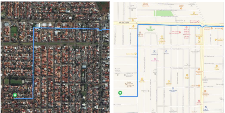
When we look at the satellite view, it looks that a misalignment over 50 meters is happening, but when we check on Hybrid and Standard views, we can see that it is an issue with the layers, not with the route itself
MNE | Comment |
Major Road Misalignment | On step N, -1.11111111, -2.22222222, route is missing a roundabout larger than 50m. It is considered a major misalignment and is rated as MNE. [link to resource]. On step N, -1.11111111, -2.22222222, route misses a slip lane/turn channel that measures more than 100m from its start (and/or blue line crosses it more than 50m from its starts). It is considered a major misalignment and is rated as MNE. [link to resource]. On step N, -1.11111111, -2.22222222, route is more than 50 meters misaligned with real world. Standard and Satellite views and other maps providers were checked and confirm the MNE. [link to resource]. |
Physically impossible | On step N, -1.11111111, -2.22222222, route takes user to a road that does not exist in real world. It is physically impossible. [link to resource]. On step N, -1.11111111, -2.22222222, road map has been updated and the maneuver is not possible anymore. Standard and Satellite views and other maps providers were checked and confirm the MNE. [link to resource]. On step N, -1.11111111, -2.22222222, route crosses a physical barrier, as seen on street imagery from December 2020. It is physically impossible. [link to resource]. |
Access restricted | On step N, -1.11111111, -2.22222222, user cannot access it, as it is a restricted area. The route is does not start there and it is not user’s destination, so it is marked as an MNE. [link to resource]. |
Cars not allowed | On step N, -1.11111111, -2.22222222, cars cannot access it, as it is a pedestrian area. The route is does not tells user to park the car and walk in this area, so it is marked as an MNE. [link to resource]. |
Against traffic | On step N, -1.11111111, -2.22222222, route takes user against traffic as seen on street imagery from December 2020, and traffic signs. [link to resource]. |
Illegal U-turn | On step N, -1.11111111, -2.22222222, route takes user to make an illegal U-turn. [Explain why U-turn is illegal]. [link to resource]. |
Turn restriction | On step N, -1.11111111, -2.22222222, route takes user to make a right/left turn that is not allowed as seen on street imagery from December 2020 and traffic signs. [link to resource]. On step N, -1.11111111, -2.22222222, route takes user to make a right/left turn that is not allowed as seen on street imagery from December 2020, continuous yellow line indicates the turn is illegal. [link to resource]. |
Other | On step N, -1.11111111, -2.22222222, [explain with details what is wrong with the route]. [link to resource]. |