This document contains important information and useful tips that will help you avoid making common mistakes when rating MNE Driving Routing tasks – Mexico.
This type of MNE occurs when the route uses roads that do not exist in real life, or requires the user to perform impossible driving maneuvers like trespassing physical barriers or navigating through POI’s or long term constructions.
In the example below, it may seem that the route is possible, however, if we use the satellite layer or streetview, we can verify that the route takes the user through a theme park (PortAventura World), where vehicle access is physically impossible.
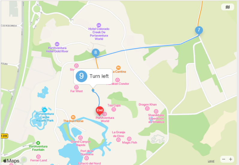
It can be confirmed with street imagery, that steps of the route (7, 8, and 9) take the user inside an amusement park with access restrictions to regular traffic:
This type of MNE occurs when the route uses a road that does not allow cars (ex. bus/motorcycle/bicycle/ pedestrian only roads).
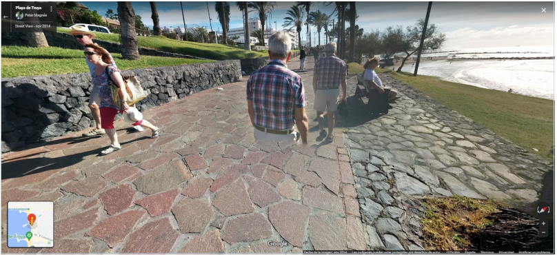
When we work with routing tasks, we have to pay attention to the beginning and the end of the route, specially Step 0, where MNEs are usually found.
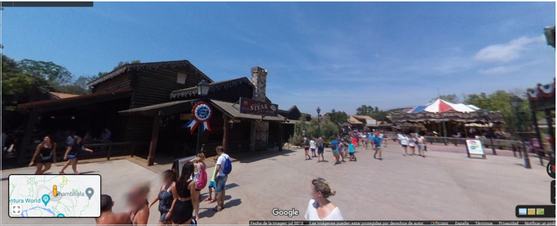
For example, in the following task, the start of the path appears to be correct by looking at the image (28.07006,-16.73251):
However, when using streetview, we can visualize that the road is not one for vehicles.
By researching the photos provided by the maps application, we can verify that it is in fact, a pedestrian street, where cars cannot access. This is a cars not allowed MNE.
This type of MNE occurs when the route asks you to take an illegal turn.
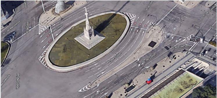
The following route indicates the user to turn left onto Plaza de Colón on step 9, which at simple sight, it might be possible:
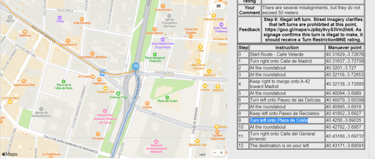
However, satellitery image shows that the detour to the left may be illegal (40.42782,-3.6957):
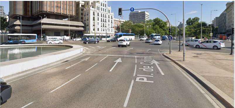
Street imagery, satellite views and other maps applications should always be used to investigate, and decide if it is possible to actually follow the indications as the route suggests, which in this case is not possible.
When using Streetview, it is possible to see that there is a signal at the traffic light and ground signals, that indicate that a left turn is not possible. For this Task we must use the rating: Turn Restriction.
When we work with routing tasks, we must pay special attention to intersections on urban roads. Most of the illegal turns, which we go undetected when evaluating routes, tend to be on those roads.
For example, in the following task, the route indicates the user to turn left on step 8 (40.40785,3.3645):
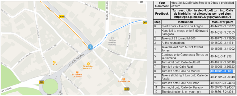
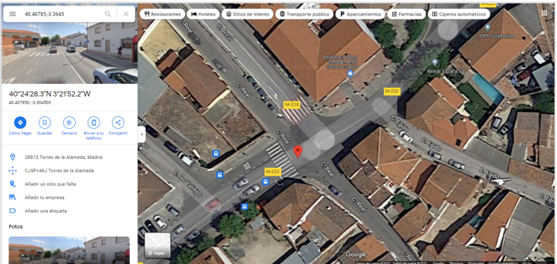
However, in the satellite image we can see a sign on the road that forces the user to turn right:
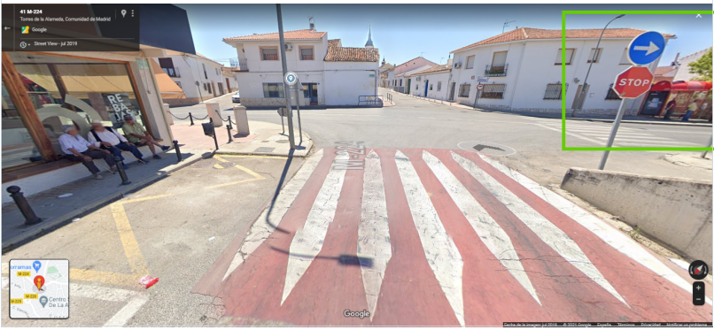
One last check using streetview confirms that the left turn is wrong. The road sign is clear:
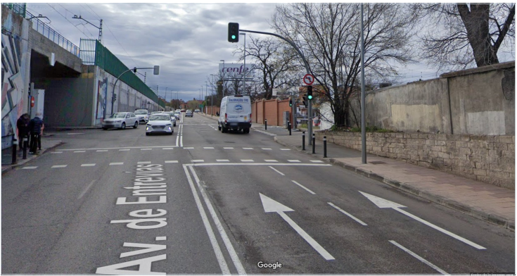
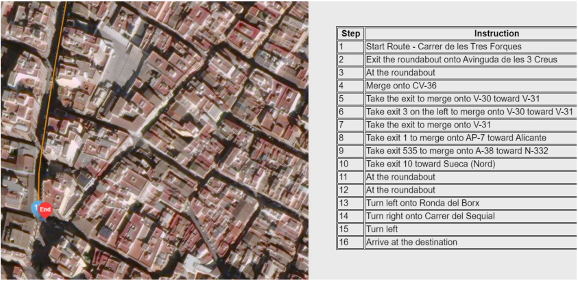
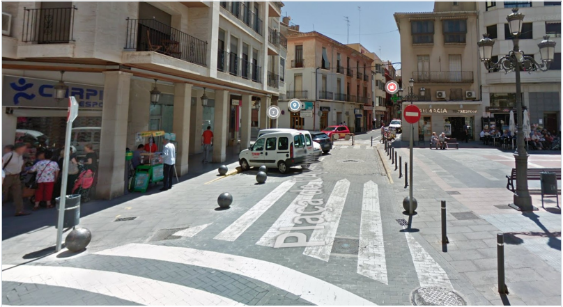
We can find another similar example in this task, where the route indicates the user to turn left on step 5 (40.38978,-3.67172):
When using Streetview, it is possible to see that there is a signal at the traffic light and ground signals, that indicate that a left turn is not possible. For this task we must use again the rating Turn Restriction.
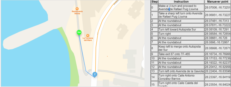
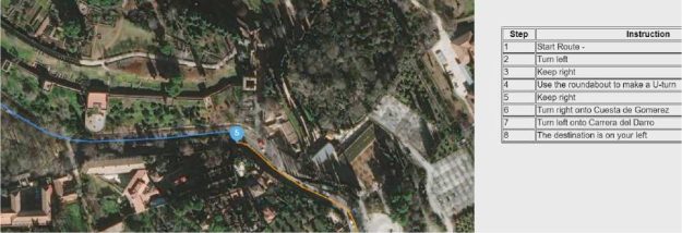
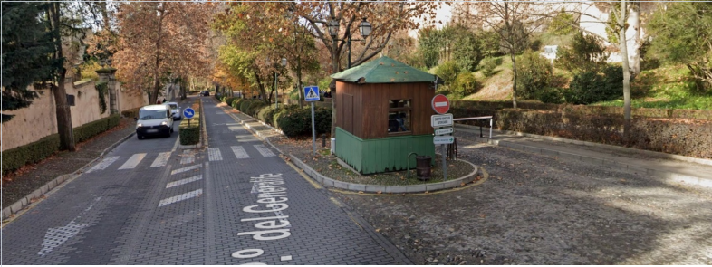
This type of MNE occurs when the route asks you to make an illegal U-Turn, including illegal U-Turns at the start of a route.
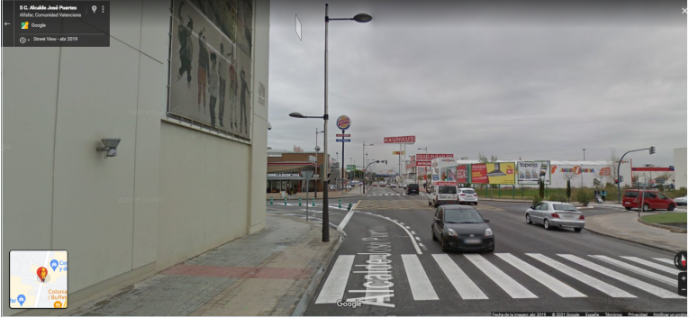
In this example, the route indicates the user to make a U-turn in step 21 (39.41517, -0.3813), which is unusual:
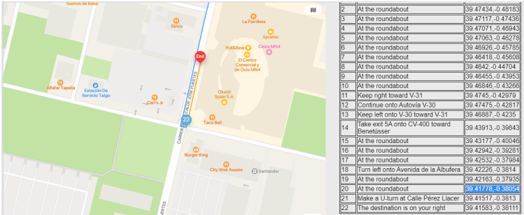
In this case, if we access streetview, we can clearly see that the U-turn is not possible.
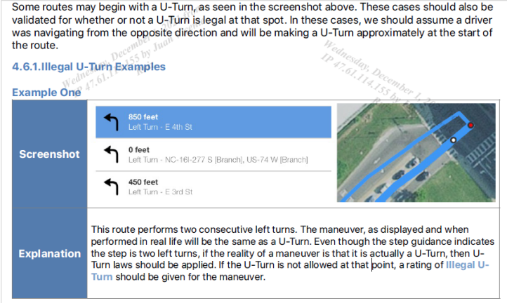
We can find a similar example in page 40 of the guidelines: “Example one” of 4.6.1 Illegal U- Turn Examples, see below:
This type of MNE occurs when the route navigates the wrong way down a road. Against Traffic is primarily used when we have evidence the user will believe that they are being routed the wrong way down a dual-carriageway or one-way road.
As we said previously, when we work with routing tasks, we have to pay special attention to the beginning and the end of the route, where MNEs are usually found. Against traffic is a common MNE in those steps.
In this example, the last step of the route indicates that we have to turn left at 39.2026,0.31065.
Using streetview we can see that this is a one-way street. So this is an Against Traffic MNE.
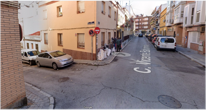
In this case the MNE is in the beginning of the route, where the first step indicates the user to turn left at 40.39923,-3.66257:
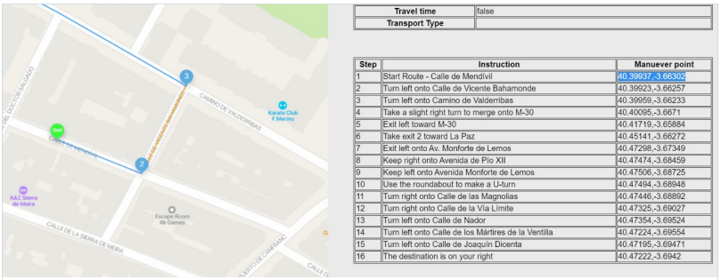
Again, using streetview we can see that this is a one-way street. So this is also an Against Traffic MNE.
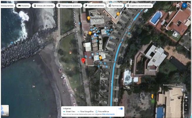
This type of MNE occurs when the route navigates through an area that limits road usage to only those with special access (private roads, parking lots, gated communities, military bases).
While we follow the route using satellite view and other maps applications, we have to pay attention if the route enters in some kind of private or restricted access area.
In this example the route indicates on step 4 to travel through a gated checkpoint into a restricted area only available to hotel guests (37.17436, -3.58532).
Using streetview we see the access to this restricted area:
When an MNE is found, always leave a comment that includes:
Examples of a good comments: MNE | Comment | |
Major Road Misalignment | On step N, -1.11111111, -2.22222222, route is missing a roundabout larger than 50m. It is considered a major misalignment and is rated as MNE. [link to resource]. On step N, -1.11111111, -2.22222222, route misses a slip lane/turn channel that measures more than 100m from its start (and/or blue line crosses it more than 50m from its starts). It is considered a major misalignment and is rated as MNE. [link to resource]. On step N, -1.11111111, -2.22222222, route is more than 50 meters misaligned with real world. Standard and Satellite views and other maps providers were checked and confirm the MNE. [link to resource]. | |
Physically impossible | On step N, -1.11111111, -2.22222222, route takes user to a road that does not exist in real world. It is physically impossible. [link to resource]. On step N, -1.11111111, -2.22222222, road map has been updated and the maneuver is not possible anymore. Standard and Satellite views and other maps providers were checked and confirm the MNE. [link to resource]. On step N, -1.11111111, -2.22222222, route crosses a physical barrier, as seen on street imagery from December 2020. It is physically impossible. [link to resource]. | |
Access j restricted | On step N, -1.11111111, -2.22222222, user cannot access it, as it is a restricted area. The route is does not start there and it is not user’s destination, so it is marked as an MNE. [link to resource]. | |
Cars not allowed | On step N, -1.11111111, -2.22222222, cars cannot access it, as it is a pedestrian area. The route is does not tells user to park the car and walk in this area, so it is marked as an MNE. [link to resource]. |
Against traffic | On step N, -1.11111111, -2.22222222, route takes user against traffic as seen on street imagery from December 2020, and traffic signs. [link to resource]. |
Illegal U-turn |
On step N, -1.11111111, -2.22222222, route takes user to make an illegal U-turn. [Explain why U-turn is illegal]. [link to resource]. |
Turn restriction | On step N, -1.11111111, -2.22222222, route takes user to make a right/left turn that is not allowed as seen on street imagery from December 2020 and traffic signs. [link to resource]. On step N, -1.11111111, -2.22222222, route takes user to make a right/left turn that is not allowed as seen on street imagery from December 2020, continuous yellow line indicates the turn is illegal. [link to resource]. |
Other | On step N, -1.11111111, -2.22222222, [explain with details what is wrong with the route]. [link to resource]. |
When a Non-MNE is found, leave a comment that includes: