The goal of this task is to determine if the provided route is reflective of the road’s true layout (ground truth) and if the route contains any errors.
Step 1: Scan the task to obtain basic information about the route.
Review the Query Information, including the time the route started. This can be important for any time restrictions that occur along the route. Also scan the top of the Step List for the ETA and any advisories or notices pertinent to the route. This will further help with time restrictions, access restrictions, etc.
Step 2: Start reviewing the route inch-by-inch.
.
The best way to catch errors in a route is to follow the route from start to finish using the satellite layer and regularly comparing it to multiple other sources, such as Google and Bing maps. As you are doing this, you can keep an eye out for things like the following:
•Road Availability – Does the blue line correctly fall over roads that exist and correctly follow their path?
•Road Types & Directionality – Does the road our route falls on appear to be usable by cars? Can you see road markings or other care proceeding in the same direction that our route goes?
•Differences between our Standard Map and Other Maps – These can sometimes be indicative of road changes that might not be
visible on our satellite layer.
• Signs of Construction – In some cases, you may run across signs of road construction. When you see long term or major road construction, you should check alternate sources to try and get an idea of the road’s current shape and if the construction is on-going. Minor road work should be assumed to not alter the road network.
• Other Oddities – Anytime something looks strange, investigate further!
To start reviewing the route:
1.Make sure the Try Rating map is on the Hybrid or Satellite view and that the map window is large enough to see the route as well as possible.
2.Copy and paste the route origin pin coordinates into another map provider in Satellite/Hybrid view and again, make sure the map window is large enough to see the route as well as possible. You can also use the Try Rating Map tool to drop a pin at the starting point of the route and paste those coordinates into another map provider.
3.Starting with Step 0 follow the route inch by inch.
4.The Step List can be used to control the Task Map:
a.Click on a single step in the Navigational Directions to highlight that route step in the Map View.
b.Double click on a step to zoom in on that step.
Step 3: Deep dive on step changes and suspicious locations
While doing the inch-by-inch review of the route, there are certain times that a closer look at the route should be done. One of the best ways to do this, when possible, is to look for recent street-level imagery/street view services with other map providers.
1.Step Changes: Zoom into street view at all step changes.
2.Any time something looks wrong, different, etc: If you cannot see something well on the satellite view, something looks different between the maps you are using, or if something looks weird/suspicious, always zoom into street view.
Step 4: Determine if errors qualify as MNE or non-MNE
Once an error is found by doing the inch-by-inch review, and deep diving, you
need to determine if it qualifies as a MNE or a non-MNE. The possible MNEs
include:
1.Major Road Misalignment – A misalignment is any section of the blue line that does not match the present-day ground-truth shape and position of the roads being used. Only misalignments that are likely to cause a navigational error should be rated as an MNE. We consider a misalignment to be a Major Road Misalignment when:
a.The misalignment is more than 50 meters from the blue route line to the present-day ground truth road.
b.A missing or non-existent roundabout/traffic circle that measures 50 meters or more in diameter from the edge of outer lane at the widest point.
c.A missing, misaligned, or non-existent turn channel is misaligned over the allowed length:
i.The turn channel is greater that 100 metes long prior to intersection or indicated turn channel.
ii.The turn channel is greater than 50 meters away from the closest point on the blue line.
2.Physically Impossible – Occurs when the route uses roads that do not exist in real like or require you to perform impossible driving maneuvers (physical barriers, long-term construction, etc.)
3.Access Restricted – Occurs when:
a.A route passes through a restricted access area or uses a road that the average driver would not be allowed to use.
i.route passes though a gated community that it does not start in or end in.
ii.route takes a shortcut through the parking area of a parking lot that it does not start in or end in.
b. A route uses a road with a time-of-day restriction during the restricted time of day.
Not Allowed – Occurs when a route uses a road that does not allowed – Occurs when a route uses a road that does not allow for the usage of a typical car. Things such as roads or pathways that are limited to buses, motorcycles, bicycles, and pedestrians. This includes at he beginning or end of a route UNLESS the step guidance has indicated the use of a pedestrian walkway to end the route.
5.Against Traffic – Occurs when a route navigates the wrong way down a street. The most common types of Against Traffic MNEs are: t a. Illegal turn onto a one-way road.
b.Two-way road reduces to one-way road.
c.Misalignment corresponds with driving the wrong direction on a road in such a way that a user may follow the misalignment.
6.Illegal U-Turn – Occurs when we instruct the user to make a U-turn where no U-turn is allowed, either by signage or local law.
7.Turn Restriction – Occurs when the route has asked you to make a turn that is physically possible but disallowed by signage or other restrictions. This may be a limitation by vehicle type (bus-only turn lanes), time of day or permanent turn restrictions.
8.Other – When you notice the route performing a maneuver that is illegal but does not fit into the other MNE categories.
Please refer to Section 4 of the Routing Guidelines for more information on Major Navigational Error Criteria and Section 3.2 Non-MNE Issues.
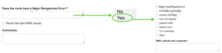
1.If an error is determined to qualify as an MNE, you must answer questions in the rating tool. First select “Yes” to the question “Does the route have a Major Navigational Error?” Then you also must select which type of MNE it is and include the Latitude and Longitude where the MNE occurs.
2.If an error is determined to be a non-MNE, check the “Route has Non- MNE Issues” box on the rating tool, leave a comment, and continue rating until the route is completed or an MNE is found.
Step 5: Leave comments
When any type of error is found, a comment is required. The comment should include the Step Number of the error, the location coordinates, the type of error found,^and a description of the error. Also include links to research used. For any long links, please use a URL shortener.
Step 6: Stop rating once an MNE is found.
Once an MNE is found, the rating questions should be answered, a comment should be left, and rating should stop at that point.
Common Mistake 1: POI – Other (Non-Transit) Example: Query: Edinburgh Airport User Location: 59.21630859375, 11.00830078125 Viewport Age: Fresh Test Locale: Norway Edinburgh Airport is an airport located in Scotland. According
Use this rating if the TryRating result is an address result (the rating should NOT be applied to POI and Business results) and there is strong evidence the address does
1.Introduction. This document contains important information and useful tips that will help you avoid making common mistakes when rating MNE Driving Routing tasks – Italy. 2.Turn Restriction Please pay attention