This document contains important information and useful tips that will help you avoid making common mistakes when rating MNE Driving Routing tasks – Italy.
Please pay attention at every turn to possible restrictions such as double solid lines, vertical traffic signage or due to vehicle type limitations. In most cases, discovering a turn restriction will require the use of street imagery.
Example 1
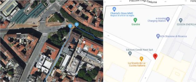
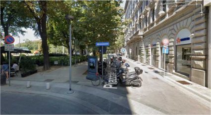
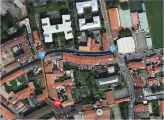
In this example, the route starts directing the user towards a parking area for motorcycles (coordinates 45.4674, 9.1775). This segment cannot be used as there is a vertical signal for mandatory turn left, which could be confirmed with Street view (see image below)
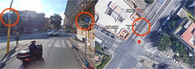
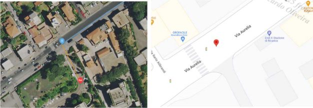
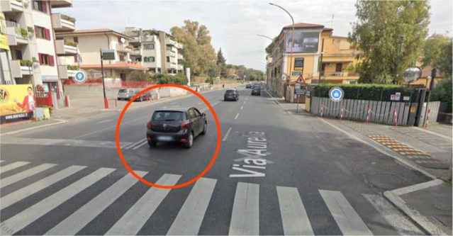
In this example, user is traveling along Via Salaria from north-east to south-west and instructed to make a left turn to Via Chiana (coordinates 41.923036,12.502309):
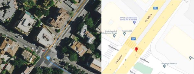
However, left turn is not allowed here as per horizontal and vertical signage visible in satellite and street imagery (see below):
In this case, route takes a left turn just before arriving at the destination (41.89642,12.4198). However, double solid line and painted arrows are visible in street imagery that indicate that left turn is not allowed here (see below).
According to law in Italy U-turns are prohibited in proximity of intersections, curves and speed bumps (Art. 154, comma 6). In terms of law there is no difference between intersections that have traffic lights are those that do not, and U-turn is forbidden in any case https://www.aci.it/i- servizi/normative/codice-della-strada.html.
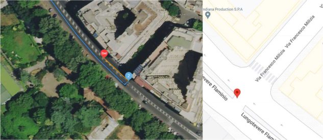
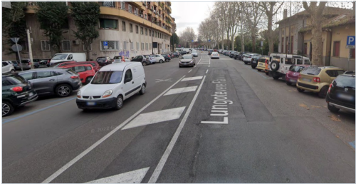
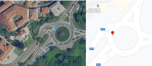
In this example, the route is taking a U-Turn on the intersection between Lungotevere Flaminio and Via Francesco Milizia, on 41.92503,12.46271. There is not any sign of U-Turn Forbidden, however this turn is not allowed under the Italian traffic law. Also, considering safety of a manoeuvre, in this case this is a busy street so a U-turn would be dangerous without a proper turn signal, etc. (GLs 4.7.1 ex. 2). In this case there is an MNE due to Illegal U-Turn.
As per Gls section 4.3. an Access Restriction MNE occurs when:
Routes whose blue route line begins or ends in a restricted access area or on a private road are assumed to have access to those roads and areas.
In Italy, areas of historical city centres are often restricted for traffic (so called ZTL – Zona a Traffico Limitato). However, as per Gls, if route begins or ends within a ZTL or resident only area we do not consider it Restricted Access MNE.
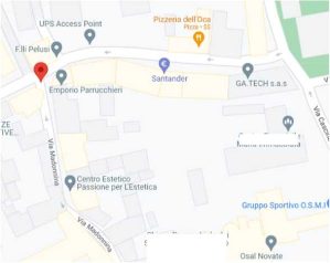
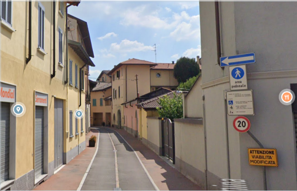
In this example, user is instructed to turn left to Via Madonnina (coordinates 45.5332,9.13999). Street imagery shows access restricted signage on the intersection (see below). However, restriction applies only to non-residents and since destination is just down the road we can assume that user has permission to access this area. It is not to be considered MNE.
Please note that temporary traffic deviations and restrictions due to short term road works or constructions shouldn’t be considered MNE and always remember to use the most recent imagery available.
See below.
A route has an Against Traffic error when it navigates the wrong way down a street. Against Traffic should only be used in cases where a user following the blue line would think they are being instructed to drive the wrong way down a road. You should use a combination of the way the route line has been visualized, the ground-truth road network, and context provided by the step list to determine if the route qualifies for an Against Traffic error.
In many cases, the blue route line may be drawn on the wrong side of a road on the satellite layer without being an MNE. This often occurs because of the difference between how the road looks in reality vs how the road has been visualized within our map. For roads that are visualized as undivided, the blue line is typically drawn directly down the middle of the road. In some cases, a road may be slightly misaligned and the blue line drawn down the center is drawn over the wrong direction of traffic in the satellite layer. In these cases, however, no user would think that they are being instructed to drive on the wrong side of the street.
Example 1
In this example, user is traveling westward toward the intersection and instead taking a turn channel to the right, blue line continues straight going against traffic direction (coordinates 45.512156, 12.237817). It might look like an MNE.
However, as per Gls section 4.1.3. example 4, we rate this example using Turn Channel rules. As per rules, only misalignment of more than 50 meters is considered an MNE. Because the center of the correct lane from the turn-channel is never more than 50 meters off from the blue line, this should be rated as having Non MNE Issues.
Example 2
Similarly to the example 1, here user is exiting the roundabout and instead of taking the correct exit they are instructed to take lane against traffic. In this case too we will apply Turn Channel rules and since the center of the correct lane from the turn-channel is never more than 50 meters off from the blue line, this should be rated as having Non MNE Issues.
This kind of misalignment is common and it is unlikely to cause confusion for the user.
In this example, the route is indicating a turn that is not possible in real life on 38.687700, 16.549670, as route is moving though physical barrier just before the very last segment of the route when user is guided into a pedestrian only area as can be confirmed with satellite imagery above and street imagery (see below) . This J is consid ered Physically Impossible.
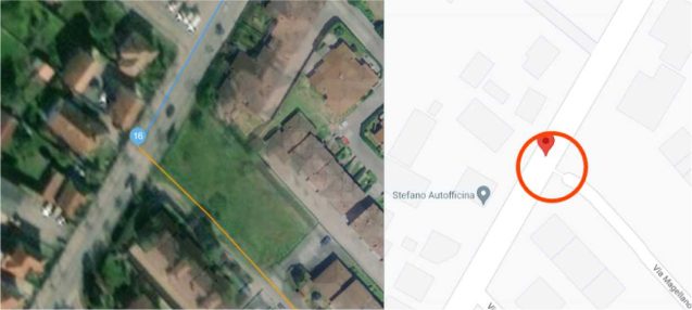
In this example, user is instructed to make a left turn onto Via Magellano. Satellite imagery shows that Via Magellano doesn’t seem fully connected to the main street.
Street imagery confirms that user cannot complete last suggestion and turn left into via Magellano because the access is blocked by a barrier – a gate that doesn’t seem to be in use.
When the route does have a Major Navigational Issue, it is required to indicate on which step the MNE was found.
See the table below, which contains examples for good comments.
MNE | Comment examples |
Major Road Misalignment | On step , -1.11111111, -2.22222222, route is missing a roundabout larger than 50m. It is considered a major misalignment and is rated as MNE. [link to resource]. On step , -1.11111111, -2.22222222, route misses a slip lane/turn channel that measures more than 100m from its start (and/or blue line crosses it more than 50m from its starts). It is considered a major misalignment and is rated as MNE. [link to resource]. On step , -1.11111111, -2.22222222, route is more than 50 meters misaligned with real world. Standard and Satellite views and other maps providers were checked and confirm the MNE. [link to resource]. |
Physically Impossible | On step , -1.11111111, -2.22222222, route takes user to a road that does not exist in real world. It is physically impossible. [link to resource]. On step , -1.11111111, -2.22222222, road network has been updated and the manoeuvre is not possible anymore. Standard and Satellite views and other maps providers were checked and confirm the MNE. [link to resource]. On step , -1.11111111, -2.22222222, route crosses a physical barrier, as seen on street imagery from December 2020. It is physically impossible. [link to resource]. |
Access restricted | On step , -1.11111111, -2.22222222, user cannot access it, as it is a restricted area. The route is does not start there and it is not user’s destination, so it is marked as an MNE. [link to resource] |
Cars not allowed | On step , -1.11111111, -2.22222222, cars cannot access it, as it is a pedestrian area. The route is does not tells user to park the car and walk in this area, so it is marked as an MNE. [link to resource]. |
Against traffic | On step , -1.11111111, -2.22222222, route takes user against traffic as seen on street imagery from December 2020, and traffic signs. [link to resource]. |
Illegal U-Turn | On step , -1.11111111, -2.22222222, route takes user to make an illegal U-turn. [Explain why U-turn is illegal]. [link to resource]. |
Turn Restriction | On step , -1.11111111, -2.22222222, route takes user to make a right/left turn that is not allowed as seen on street imagery from December 2020 and traffic signs. [link to resource]. On step , -1.11111111, -2.22222222, route takes user to make a right/left turn that is not allowed as seen on street imagery from December 2020. [link to resource]. |
Other | On step , -1.11111111, -2.22222222, [explain with details what is wrong with the route]. [link to resource]. |