Sometimes you can easily spot a problem area in a task route by requesting the same route in a different map application and quickly comparing the shapes of the routes. Investigate any obvious differences to determine whether they are caused by a Major Navigational Error in the TryRating route. If you find an MNE, you do not need to continue checking the remainder of the route.
Tips and Tricks
The basic goal of the Routing task is to check if the route returned by TryRating can be used in the real world, if the roads exist and can be used according to the given directions. You may come across cases when the road is not physically there, or there is an obstacle which makes it impossible for a car to perform the required maneuver. The two following sections deal with the two scenarios.
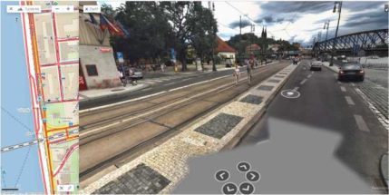
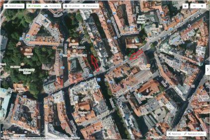
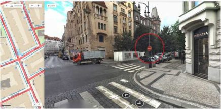
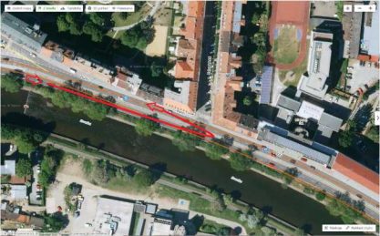
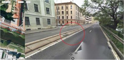
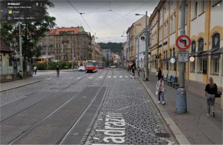
Sometimes there is a step in the route which is impossible to make in reality. You need to pay attention to the physical reality of roads, intersections etc., the street imagery or streetview is very helpful in this case. In the following example the user would be told to turn left from the street Rašínovo nábřeží onto the street Na Hrobci.
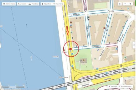
The standard map layer in this image does not show anything unusual, however, when we look at street imagery, we see a tram isle in the middle of the street which makes the turn impossible.
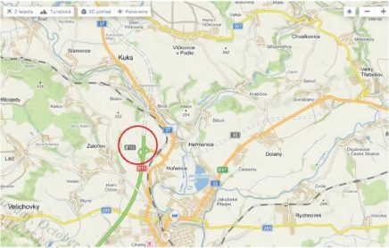 In some cases, the route navigates through a road which is not yet finished. It is necessary to check the physical state of road, there might be signs of construction works going on, or the road might not be visible on the map at all. In the following example the user would be told to keep going straight using the D11 motorway, but actually the motorway is not yet finished beyond the exit 113 (indicated by dashed line on the map).
Commented [Tk1]: Updated example: The part of motorway near exit 90 is finished so I inserted number and pictures of the next unfinished part of D11 as an example I
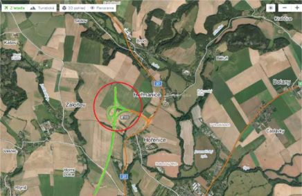
The satellite map layer is also useful in this case, the signs of construction works are visible to some extent.
In the case of unfinished roads, you can look for the official documentation of the Road and Motorway Directorate of the Czech Republic, or look at their official website (https://www.rsd.cz/wps/portal/) which includes current information on the ongoing construction works of roads and is very useful.
Sometimes the route might direct the user to make a turn onto a street where traffic is allowed only in the opposite direction. It happens especially in urban areas with high density of buildings and cars. This error is usually hard to spot using only the satellite map layer, it is necessary to use street imagery and look for any street signs indicating the driving direction. In the example below the user would be told to turn right from the street Široká onto the street Pařížská. This is in fact against traffic, but it´s impossible to tell from the satellite layer only.
When you look at the following street view image, you can see that there is a “against traffic” sign visible.
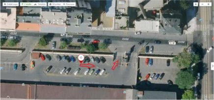
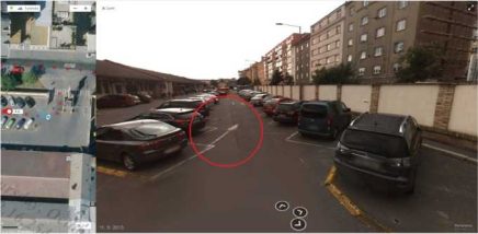
Another case of Against traffic error is when the user is told to drive through a parking lot in a direction which is not allowed. Through some parking lots you can drive in either direction, but in other parking lots there is only one allowed driving direction and it´s usually indicated by arrows on the road surface, by street signs or in some other way. In the following example the user would be told to exit the parking lot in the direction of the red arrows. However, when you look at both the satellite map layer image (above) and the street imagery (below), you can see that there are white arrows indicating the direction at the ground in the parking lot, and the route is actually telling the user to go in the opposite direction, which is against traffic.
U-turns are not always legal in the Czech Republic, always look for the following when verifying a U-turn:
In the following example the user is told to make a U-turn at an intersection of the streets Poříčí and Zahradnická.
When we look at street imagery (below), we see that the U-turn is illegal at this point as a white solid line in the middle of the street forbids the turn.
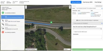
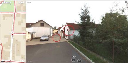
Some routes may begin with a U-Turn, as seen in the screenshot below. These cases should also be validated to confirm if a U-Turn is legal at that spot. In these cases, we should assume a driver was navigating from the opposite direction and will be making a U-Turn approximately at the start of the route. See GL 4.6 for more details.
As visible in Satellite View and also in Street Imagery, U-turn is not permitted as indicated by road surface sign.
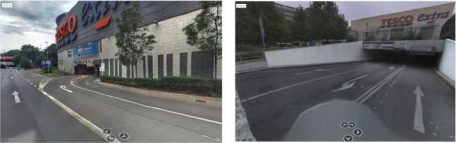
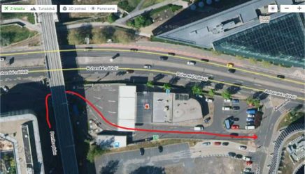
There are cases when the route requires the user to drive through a parking lot, but the route neither starts, nor ends inside the parking lot. Such a case would be classified as Access restricted MNE. In the example below the user is directed to turn right and drive through an underground parking area of a shopping mall, exit it on the other side of the mall and keep going.
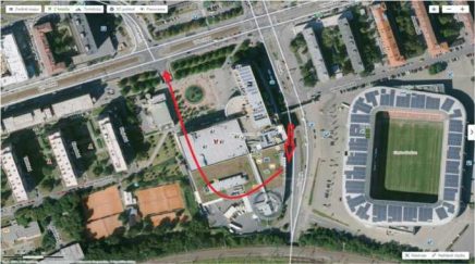
In the following StreetView images you can see the points where the route enters and exits the shopping mall parking lot.
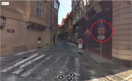
The Access restricted MNE does not apply to parking lots only, it can occur whenever the user is asked to drive through a street where there is an Access restricted sign at the beginning. This can often be the case in urban areas such as big cities. It is important to check whether the route ends in this particular street, or if it goes on to another street. In the following example the user is asked to enter a street with an Access restricted sign. It is the street Jilská in Prague.
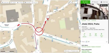
When you see this sign, you should check the end of the route. In the following picture you see the end of the route as the red pin. The route ends in the street Jilská shortly after its beginning. In this case it is not an MNE, because the route ends in the access restricted area and we can assume that the user has permission to enter this area. There is no other way of accessing this particular address. As per GL 4.3 Routes whose blue route line begins or ends in a restricted access area or on a private road are assumed to have access to those roads and areas
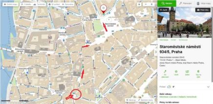
The following picture shows a different scenario. The user is asked to enter the same street, however, this time the route goes on to a different street and ends after several more turns. In this case it should be rated as MNE – Access restricted.
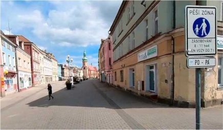
Another type of quite common Access restricted situation in city center is that the entry is only permitted during certain hours. In the following example, there is a pedestrian zone and only supplying cars can enter during weekdays from 8 to 11 am.
Another type of Access restricted MNE is unnecessary driving through the gas station. It’s the same logic as in the case of unnecessary driving through the parking lot – if the route does not start or end there, it should be marked as MNE. See the example below, the user is directed to drive through a gas station.
Another common error that appears in the routing tasks is a Cars not allowed MNE. It occurs when the route leads the user through a road or path that can only be used by busses, bicycles, motorcycles or pedestrians. You should always look for street signs and pay attention to the physical reality – there may be physical obstacles in the way or the road might be unsuitable for the use of cars in some other way (e.g. a pedestrian walkway only etc.).
In the following example there is a sign “Access restricted” visible on street view as well as a physical barrier at the beginning of the street. This street is for pedestrians only.
There are cases when the route asks you to take an illegal turn. Some cases may be tricky – the sign showing Turn restriction could be further away from the intersection than you would expect, just like this one:
User is asked to turn left but according to the sign, turning left is allowed only for public transport, TSK, IZS and bikes.
A good comment should include the ID of the step where the MNE was found, a short explanation of the MNE, and links to any sources with evidence supporting the rating. The following table includes examples of good comments.
MNE | Comment |
Physically impossible | MNE at step 1: highway at the point indicated is not finished yet, see http://tinyurl.com/xyz. MNE at step 6: the route requires the user to turn left, however, there is a tram isle in the middle of the street which makes the turn impossible, see http://tinyurl.com/xyz. |
Against traffic | MNE at step 3: user is supposed to exit the parking lot the other way around. Verified via street level imagery where directionality arrows are visible, see http://tinyurl.com/xyz. MNE at step 2: the route requires the user to take a turn right, however, this is against traffic, see the street level imagery http://tinyurl.com/xyz. |
Illegal U-turn | MNE at step 4: U-turn is illegal at this point as a white solid line forbids the turn – verified via street level imagery (http://tinyurl.com/xyz). MNE at step 3: U-turn is illegal at an intersection with traffic lights indicating the direction (http://tinyurl.com/xyz). |
Access restricted | MNE at step 7: user is instructed to drive through a parking lot, the route neither starts nor ends here, therefore as per GL ch. 4.3. this is MNE – Access restricted (http://tinyurl.com/xyz). |
Cars not allowed | MNE at step 9: Cars not allowed at this point – the path is only for pedestrians. It can be Physically impossible as well as there are visible barriers – verified via street level imagery and satellite view (http://tinyurl.com/xyz). |
Turn restriction | MNE at step 3: User isn’t allowed to turn to the left as this road is only for buses (http://tinyurl.com/xyz) |