The best way to spot errors on a route is to follow the route from start to finish using the Satellite or Hybrid layer, and regularly compare the route to alternate sources of map information. Most Major Navigational Errors (MNE) occur at step changes, in places where the vector and satellite layers do not match up, or in places where third-party mapping services suggest a significantly different route. High-risk areas should be checked using street photography where available.
In this document, we will cover some frequent errors we have encountered when reviewing routing tasks in the fr_FR market and provide examples to help illustrate
An Access Restriction MNE occurs when:
average driver would not be allowed to use.
on a private road are assumed to have access to those roads and areas.
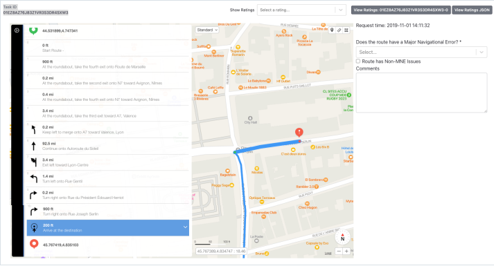
Common Mistake 1:
Majority of analysts rated this task as an MNE
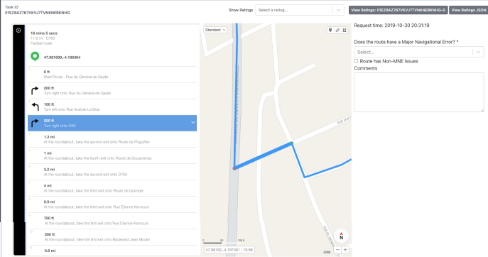
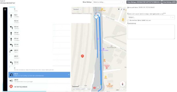
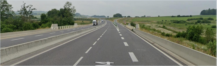
Step 10 : Lat/lng 45.767273,4.834444 – Blue route ends on a street with
Access Restricted so NOT an MNE (GL 4.3)
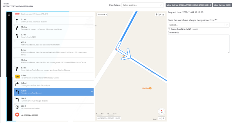
Common Mistake 2:
Majority of analysts rated this task as an MNE
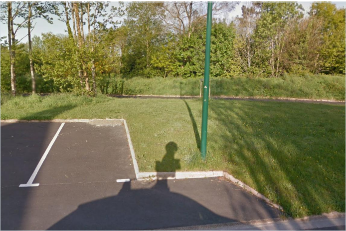
Step 12: Lat/lng 49.257761,4.031626 – blue route ends in a restricted area
(roadblocks) so NOT an MNE (GL 4.3)

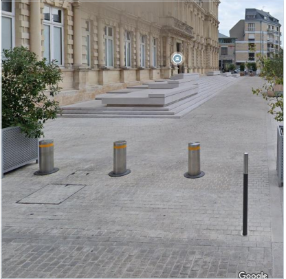
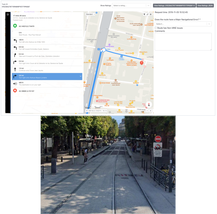
Access Restricted example:
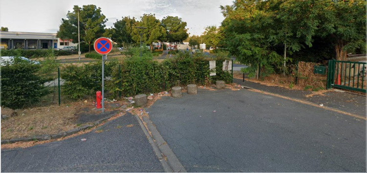
Step 18: Issue Lat/lng 46.675542,4.363441, access restricted for service vehicle only.

A Cars Not Allowed error occurs when the route uses a road that does not allow for the usage of a typical car. Common examples of these are roads or pathways that are limited to buses, motorcycles, bicycles and pedestrians. Unlike the Access Restriction MNE, a Cars Not Allowed MNE applies even for cases of Cars Not Allowed areas at the beginning or end of the route. The only exception for this is when step guidance has indicated the use of a pedestrian walkway to end the route.
Common Mistake 3:
Many Analysts did not rate MNE here. There is an MNE Step 6: Issue Lat/lng
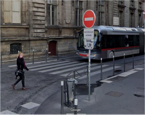
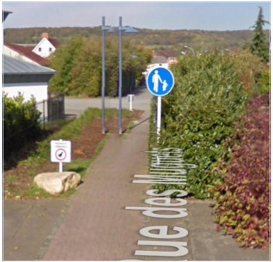
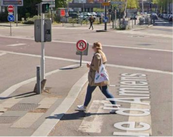
Cars Not Allowed example:
Issue Lat/lng 49.56984,5.908845: Pathway is limited to pedestrian
In some cases, the step list will include a direction for the user to park the car and walk the remainder of the distance. In that case, the route line may go over a pedestrian-only path or trail without being an MNE.
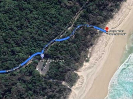
In this example, the blue route line enters a parking lot, and then continues onto a pedestrian path to arrive at the beach. If the step guidance correctly indicates a pedestrian pathway by either a step that says “Arrive End of Navigation” followed by additional steps, or a step that says “Prepare to park your car” followed by additional steps, then this part of the route should not be considered to have a Cars Not Allowed MNE.
The step guidance text is considered acceptable even if it is in a foreign language – use online translation tools if necessary.
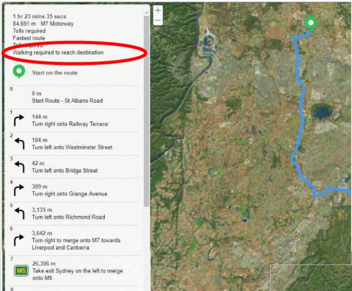
The step list will advise at the beginning if the route includes walking.
A route has an Against Traffic error when it navigates the wrong way down a street. Against Traffic should only be used in cases where a user following the blue line would think they are being instructed to drive the wrong way down a road. You should use a combination of the way the route line has been visualized, the ground-truth road network, and context provided by the step list to determine if the route qualifies for an Against Traffic error.
The three most common types of Against Traffic MNEs are:
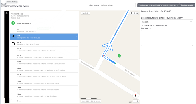
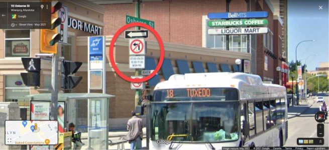
Common Mistake 4:
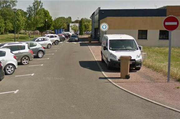
Many analysts did not rate MNE here. Step 1- Lat/lng 46.834771,-1.881231 route requires user to turn right into a street with no entry sign according to street view (against traffic)
Against Traffic example:
Issue Lat/lng 43.647428,1.369259: Against traffic as indicated by the painted arrow
A Physically Impossible MNE should be selected when the route uses roads that do not exist in real life or requires you to perform impossible driving
manoeuvres (ex. Manoeuvre ignores differences in overpasses/underpasses, physical barriers between the roads, navigates through impassable long-term construction).
Physically Impossible examples:
Step 14: Issue Lat/lng 47.208241,-1.542695, the place isn’t accessible to vehicles.
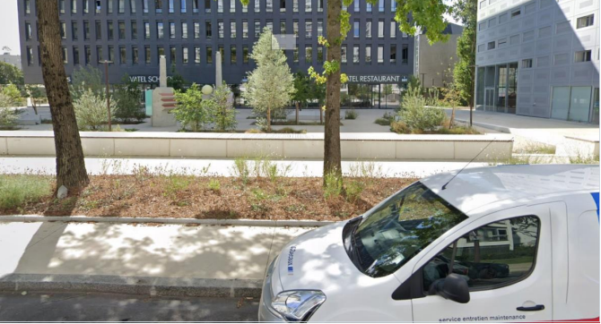
Step 3: Issue Lat/lng 47.981808,-4.187275. The blue route at this point is physically impossible since it is not a road. It is not a misalignment.
Issue Lat/lng 48.752463,2.455575, road is a dead end, there is a fence and concrete blocks:
A route has an Illegal U-Turn when we instruct the user to make a U-Turn where no U-Turn is allowed. Laws controlling U-Turns can vary widely by area. We expect that you may need to take some time to familiarize yourself with these before or while reviewing routes.
Illegal U-Turns examples:
Step 14 – Lat/lng 48.731088,2.446832 – Illegal U-turn with a continuous line on the ground that cannot be crossed.

Lat/lng 49.43873,1.107734. Illegal U-turn, there is a “No U-turn” sign:
Tips: Please always investigate when you found an MNE for maneuvers such as U Turns.
Check if a solid line is present and verify if there is not a misalignement at the turning point.
A route should be flagged as Turn Restriction if the route asks you to make a turn that is physically possible but is not allowed due to signage or other restrictions.
Example:
At this intersection, there is a time-based restriction on making left turns. Left turns are prohibited during high traffic periods, 07:00-09:00 and 15:30-17:30 Monday to Friday. To determine if a left turn at this intersection is allowed in our route, we will have to look at the timestamp in the rating tool.
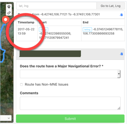
Using the information in the timestamp, we will have to find out what day of the week the timestamp corresponds to (this can be done quickly with a web search), and then estimate what time the user will arrive at this intersection to determine if this left turn is an MNE or not.
There is a misalignment with the turn channel but less than 100 meters at step 1 (pin 49.762588,4.647738), hence considered a non MNE issue.
Tip : Always use a tool to measure distances. Start measuring from the beginning of the turn channel and stop when the line become solid and make the turn illegal.
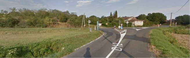
If you found intersections, it sometimes useful to verify if a roundabout has been created recently. In a following example, we can see a regular intersection on street imagery in 2008 (picture 1).
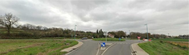
In 2022, the intersection has been replaced by a roundabout (picture 2).
When you discover an MNE, leave a comment that includes
If a route does not contain any MNEs you are not required to leave a comment, but it is still helpful to comment on any aspects of the route that required complex investigation.
Examples of good comments:
MNE | Comment |
Major Road Misalignment | On step N, -1.11111111, -2.22222222, route is missing a roundabout larger than 50m. It is considered a major misalignment and is rated as MNE. [link to resource]. On step N, -1.11111111, -2.22222222, route misses a slip lane/turn channel that measures more than 100m from its start (and/or blue line crosses it more than 50m from its starts). It is considered a major misalignment and is rated as MNE. [link to resource]. On step N, -1.11111111, -2.22222222, route is more than 50 meters misaligned with real world. Standard and Satellite views and other maps providers were checked and confirm the MNE. [link to resource]. |
Physically impossible | On step N, -1.11111111, -2.22222222, route takes user to a road that does not exist in real world. It is physically impossible. [link to resource]. On step N, -1.11111111, -2.22222222, road map has been updated and the manoeuvre is not possible anymore. Standard and Satellite views and other maps providers were checked and confirm the MNE. [link to resource]. On step N, -1.11111111, -2.22222222, route crosses a physical barrier, as seen on street imagery from December 2020. It is physically impossible. [link to resource]. |
Access restricted | On step N, -1.11111111, -2.22222222, user cannot access it, as it is a restricted area. The route is does not start there and it is not user’s destination, so it is marked as an MNE. [link to resource]. |
Cars not allowed | On step N, -1.11111111, -2.22222222, cars cannot access it, as it is a pedestrian area. The route is does not tells user to park the car and walk in this area, so it is marked as an MNE. [link to resource]. |
Against traffic | On step N, -1.11111111, -2.22222222, route takes user against traffic as seen on street imagery from December 2020, and traffic signs. [link to resource]. |
Illegal U-turn | On step N, -1.11111111, -2.22222222, route takes user to make an illegal U-turn. [Explain why U-turn is illegal]. [link to resource]. |
Turn restriction | On step N, -1.11111111, -2.22222222, route takes user to make a right/left turn that is not allowed as seen on street imagery from December 2020 and traffic signs. [link to resource]. On step N, -1.11111111, -2.22222222, route takes user to make a right/left turn that is not allowed as seen on street imagery from December 2020, continuous yellow line indicates the turn is illegal. [link to resource]. |
Other | On step N, -1.11111111, -2.22222222, [explain with details what is wrong with the route]. [link to resource]. |