Note: This learning document is based on information found in the Maps Search Evaluation Guidelines. When in doubt, always refer to the official guidelines.
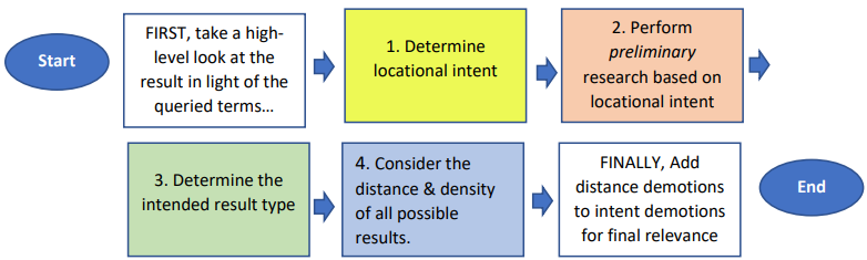
FIRST, take a high-level look at the result in light of the queried term(s).
Before considering distance, make sure the result matches the user query intent in some meaningful way as described in Search Guidelines section 5.2.
NOTE: When the user’s query/intent is unclear, you may need search the area of locational intent first in order to determine what the user is actually looking for. This is often the case with single location POIs and unusual place names.
STEP 1. Determine locational intent (2.3 Location Intent/chart)
The locational intent will be one of the following:
o when the viewport is stale,
o when the user is inside the fresh viewport,
o or when the user explicitly queries “nearby” or “near me” etc.
o General: in/near a named neighborhood, locality, region etc. For general location intent, a single match within could be navigational; while multiple would each be rated excellent. zAny outside of the named locality would be demoted based on distance/density.
o Specific: on/near a named street. As long as at least one matching result is on the named street all other results would be rated bad. If there is no match on the street; then other matching results are rated according to distance/density.
Obtain the coordinates of the fresh viewport/user’s position OR other target locality etc. as described in Step 1, and enter this information in your preferred map application as the starting point for your real-world search for the queried business/POI, category or address.
TIP: Some map applications have more than one search function. For example, one popular map application has a “Directions” and a “Nearby” function that produce different types of results. “Direction” searches usually produce a set of matching street addresses or POI + street addresses in some cases. “Nearby” searches usually produce POI names + street addresses. It is a good idea to familiarize yourself with the various search functions of your chosen map application to understand what type of results can be produced from each.
Depending on the intent type, the locational intent will be more or less important as described below.
o If there is only one clear business or POI match, a non-matching result would be demoted for “bad” for intent and distance is not critical.
o If the intent is a chain business, distance from locational intent is critical.
o If the intent is a category/type of business or POI, then distance from locational intent is critical.
o If there is only one clear address match, a non-matching result would be demoted for “bad” for intent and distance is not critical.
’
o If the intent is a partial address (for example a street name without a locality or a street number + common street name without a locality etc.), then distance from locational intent is critical.
o If the intent is a rail or bus station/stop, there are very specific rules with regard to demotions for distance. The major considerations for transit ratings per “5.16 Transit Intent” are:
Consider the density/number of possible results. “Density” most often comes into play for chain business and category queries; but it can also apply to partial address searches.
FINALLY, add distance demotions to any taken for intent to determine final relevance rating
General Key points regarding distance:
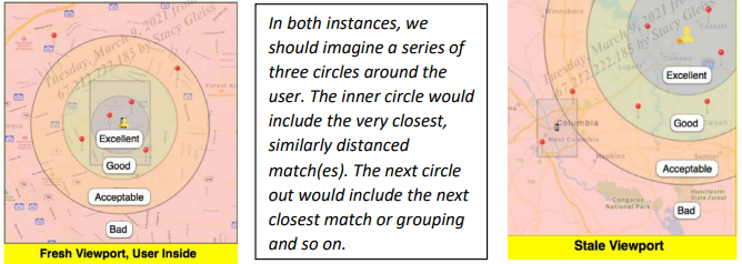
o When the viewport is the locational focus, distance is viewed as a fame that extends from the viewport shape

TIP: Take care not to be overly strict if one result is just slightly closer/further than another. Use common sense thinking about your experience as a user. For example, if a one result is just a bit further than another; but you as a user could imagine that not being a critical difference given the density of matching options, then rate both results similarly for distance.