This document will present common issues encountered by analysts in the Portuguese market and how to best address them for a correct rating.
Please find below the list of trends to help you avoid making similar mistakes in the future.
Before submitting your ratings, make sure to take enough time, do not rush, conduct proper research, and consult satellite images. If there is no street image available, look for satellite images to guide you!
Please note, this document was made in March 2022 and reviewed in September 2024. Guideline sections in this document refer to MNE Driving Routing Guidelines June 2023. Please follow the latest guidelines if there is any conflict between this document and the latest guidelines.
The tasks/answers in this document reflect information at the time they were made. It might not follow the latest real world information anymore.
However, you should still be able to learn concepts of how to rate Routing tasks.
1. Physically Impossible x Turn restriction x Cars not Allowed A route may be impossible to follow if it uses roads that do not exist in real life, or if it tells drivers to pass through permanent physical barriers.
If there is a physical barrier present, the MNE is not a turn restriction nor “cars not allowed” – the correct rating is Physically Impossible.
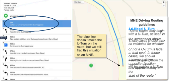
On Routing, you are reviewing the steps done by the blue line. However, there is an exception for this: when a U-turn is the first step on the list, but it’s not shown by the blue line. So, if there is a U-turn MNE in the beginning of the list of steps that is not represented by the blue line, you should flag the MNE. Example:
Please don’t rate it as an MNE before checking all your resources first.
A good amount of MNEs is located at the start and the finish of the routes. Please check if they are guiding the driver through actual ways, sometimes what looks like the entrance or exit of a parking lot, has physical barriers in the real world.

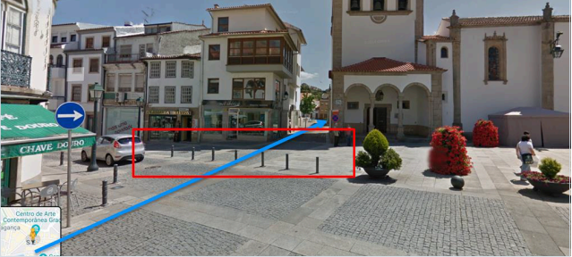
On the next example, the blue line clearly ends in the middle of a square, where only pedestrians are allowed:
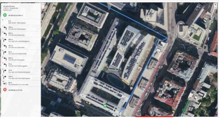
On the above example, step 1 was wrongly flagged as an MNE because it seems to be telling users to drive inside a shopping center. This case is only a minor misalignment: the blue line should be at Invalidentraße (red line).
When the route has a Major Issue, the analyst is required to indicate which step the MNE was found. Here are some examples of good comments:
Comment
MNE
On step N, -1.11111111,-2.22222222, route is missing a roundabout larger than 50m. It is considered a major misalignment and is rated as MNE. [link to resource].
Major Road Misalignment On step N, -1.11111111,-2.22222222, route misses a slip lane/turn channel that measures more than 100m from its start (and/or blue line crosses it more than 50m from its starts). It is considered a major misalignment and is rated as MNE. [link to resource].
MNE | Comment On step N, -1.11111111,-2.22222222, route is more than 50 meters misaligned with real world. Standard and Satellite views and other maps providers were checked and confirm the MNE. [link to resource]. On step N, -1.11111111,-2.22222222, route takes user to a road that does not exist in real world. It is physically impossible. [link to resource]. On step N, -1.11111111,-2.22222222, road map has been updated and the |
Physically impossible | maneuver is not possible anymore. Standard and Satellite views and other maps providers were checked and confirm the MNE. [link to resource]. On step N, -1.11111111,-2.22222222, route crosses a physical barrier, as seen on street imagery from December 2020. It is physically impossible. [link to resource]. |
Access restricted | On step N, -1.11111111,-2.22222222, user cannot access it, as it is a restricted area. The route is does not start there and it is not user’s destination, so it is marked as a MNE. [link to resource]. |
Against traffic | On step N, -1.11111111,-2.22222222, route takes user against traffic as seen on street imagery from December 2020, and traffic signs. [link to resource]. |
Illegal U-turn | On step N, -1.11111111,-2.22222222, route takes user to make an illegal U- turn. [Explain why U-turn is illegal]. [link to resource]. On step N, -1.11111111,-2.22222222, route takes user to make a right/left turn that is not allowed as seen on street imagery from December 2020 and traffic signs. [link to resource]. |
Turn restriction | On step N, -1.11111111,-2.22222222, route takes user to make a right/left turn that is not allowed as seen on street imagery from December 2020, continuous yellow line indicates the turn is illegal. [link to resource]. |
Other | On step N, -1.11111111,-2.22222222, [explain with details what is wrong with the route]. [link to resource]. |
When reviewing a route, start by checking the beginning and the end. This can save time in case there is an MNE at the end of the route.
If you immediately find anything that looks suspicious or strange along the course of a route while zoomed out, check there first, before starting to evaluate the route from the beginning.
Use the option to view history data on Google Earth. This can help to determine whether the task map shows an outdated satellite view.
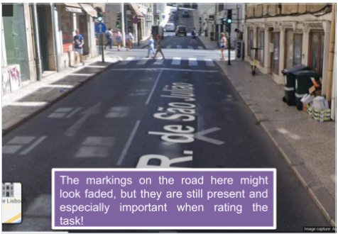
Be aware that sometimes signs on the ground might look faded, like in the image below and they can easily be missed. Make sure to look closely, so you do not miss important markings!
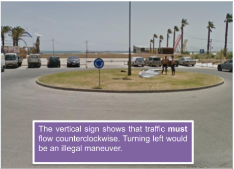
Pay attention to vertical signs on the road. A sign like the one below indicates that traffic should flow counterclockwise. For instance, turning left would be an illegal maneuver.
Example 1:
Task ID: 01EY0C8XYKM9HB37P15HBRSNRV-0
Comment: In this task many analysts rated the question “Does the route have a MNE” as “No” but the correct rating should be “Yes – Physically Impossible” as the blue line crosses a physical barrier in step 24 at coordinates 38.492958,-8.902183 as seen on the most recent street imagery on different map services. Please review section 4.2 Physically Impossible of Driving Routing Guidelines for more help.
Example 2 Task ID: 01EY0C8XPC7D8J24AZ96Y5MZJ4-0
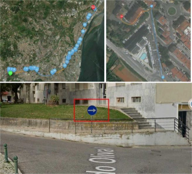
Comment: In this task many analysts rated the question “Does the route have a MNE” as “No” but the correct rating should be “Yes – Turn Restriction” as in step 41 coordinates 38.869878, -9.061787 there is a sign that says drivers should turn right and disallows left turns. Please review section 4.7 Turn Restriction of Driving Routing Guidelines for more help.
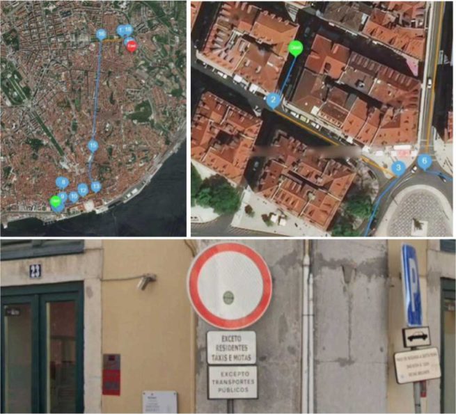
Comment: In this task many analysts rated the question “Does the route have a MNE” as “No” but the correct rating should be “Yes – Access Restricted” as in step 2 coordinates 38.70697, -9.144149 there is an access restriction sign with an exception for residents and certain vehicle types. Please review section 4.3 Access Restriction of Driving Routing Guidelines for more help.